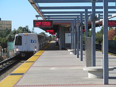
Directions to Fremont BART Station with public transportation
The following transit lines have routes that pass near Fremont BART Station
How to get to Fremont BART Station by bus?
Click on the bus route to see step by step directions with maps, line arrival times and updated time schedules.
How to get to Fremont BART Station by train?
Click on the train route to see step by step directions with maps, line arrival times and updated time schedules.
How to get to Fremont BART Station by BART?
Click on the BART route to see step by step directions with maps, line arrival times and updated time schedules.
Bus stops near Fremont BART Station
- Fremont BART, 2 min walk,
- Fremont BART (Line U Stop), 3 min walk,
Train stations near Fremont BART Station
- Fremont, 16 min walk,
Bart stations near Fremont BART Station
- Fremont, 58 min walk,
Bus lines to Fremont BART Station
- 200, Union City BART,
- 801, San Leandro BART,
- 217, Fremont BART,
- 99, Hayward BART,
- 216, Union City BART,
- 232, Newpark Mall,
- 251, Ohlone College Newark,
- AE-F, On Quarry Road @ Psychiatry Building,
- 215, Fremont BART,
- U, Fremont BART,
- 239, Milpitas Blvd. & Dixon Landing Road,
- 212, Fremont BART,
What are the closest stations to Fremont BART Station?
The closest stations to Fremont BART Station are:
- Fremont BART is 103 yards away, 2 min walk.
- Fremont BART (Line U Stop) is 163 yards away, 3 min walk.
- Fremont is 1300 yards away, 16 min walk.
Which bus lines stop near Fremont BART Station?
These bus lines stop near Fremont BART Station: 200, 212, 215, 217, 99.
Which train line stops near Fremont BART Station?
ACETRAIN
Which BART line stops near Fremont BART Station?
GREEN
What’s the nearest train station to Fremont BART Station?
The nearest train station to Fremont BART Station is Fremont. It’s a 16 min walk away.
What’s the nearest bus stop to Fremont BART Station?
The nearest bus stop to Fremont BART Station is Fremont BART. It’s a 2 min walk away.
What time is the first BART to Fremont BART Station?
The ORANGE is the first BART that goes to Fremont BART Station. It stops nearby at 4:56 AM.
What time is the last BART to Fremont BART Station?
The ORANGE is the last BART that goes to Fremont BART Station. It stops nearby at 1:32 AM.
What time is the first train to Fremont BART Station?
The ACETRAIN is the first train that goes to Fremont BART Station. It stops nearby at 5:45 AM.
What time is the last train to Fremont BART Station?
The CC is the last train that goes to Fremont BART Station. It stops nearby at 7:30 PM.
What time is the first bus to Fremont BART Station?
The 801 is the first bus that goes to Fremont BART Station. It stops nearby at 3:04 AM.
What time is the last bus to Fremont BART Station?
The 801 is the last bus that goes to Fremont BART Station. It stops nearby at 4:04 AM.
See Fremont BART Station on the map
Public Transportation to Fremont BART Station
Wondering how to get to Fremont BART Station, United States? Moovit helps you find the best way to get to Fremont BART Station with step-by-step directions from the nearest public transit station.
Moovit provides free maps and live directions to help you navigate through your city. View schedules, routes, timetables, and find out how long does it take to get to Fremont BART Station in real time.
Looking for the nearest stop or station to Fremont BART Station? Check out this list of stops closest to your destination: Fremont BART; Fremont BART (Line U Stop); Fremont.
Bus: 200, 212, 215, 217, 99, 801, 216.Train: ACETRAIN, CC.BART: GREEN, ORANGE.
Want to see if there’s another route that gets you there at an earlier time? Moovit helps you find alternative routes or times. Get directions from and directions to Fremont BART Station easily from the Moovit App or Website.
We make riding to Fremont BART Station easy, which is why over 1.5 million users, including users in Fremont, trust Moovit as the best app for public transit. You don’t need to download an individual bus app or train app, Moovit is your all-in-one transit app that helps you find the best bus time or train time available.
For information on prices of bus, BART and train, costs and ride fares to Fremont BART Station, please check the Moovit app.
Get to Fremont BART Station with public transit and pay for the ride in the Moovit app. In addition to all info you may need for your trip to Fremont BART Station, including live directions, real-time arrivals and fare prices, you can also buy public transit passes for your rides. No need for cash or paper tickets to get to Fremont BART Station - everything you need is accessible in the app with a click of the button.
Use the app to navigate to popular places including to the airport, hospital, stadium, grocery store, mall, coffee shop, school, college, and university.
Fremont BART Station Address: 2000 Bart Way (at Civic Center Dr) street in Fremont
Popular routes to Fremont BART Station
Popular routes from Fremont BART Station
Attractions near Fremont BART Station
LinkedIn East Bay Shuttle,VTA Express 181,Washington Hospital Heliport,Tule Pond,Washington Hospital,VTA Express @ Fremont Bart,Luxera,Fremont Surgery Center,ER Kaiser Fremont,Kaiser Permanente-Fremont-ER,Blue Rhino,Embarcadero Building,39400 Paseo Padre Parkway,Kaiser Permanente - Embarcadero Bldg.,Social Security Office,Fremont Bart 251 Levi Stadium,JKL,Fremont Main Library,Niles Canyon,RSM FremontHow to get to popular attractions in Fremont with public transit
Mountain View Caltrain Station,Napa Valley, Yountville,Concord BART Station, Concord,Kaiser Permanente Medical Center, Santa Clara,Trader Joe's, Oakland,Googleplex - 43,De Anza College, Cupertino,City of Rohnert Park, Rohnert Park,City of Pinole, Pinole,City of Morgan Hill, Morgan Hill,Nordstrom Valley Fair, San Jose,San Ramon, San Ramon,City of Pleasanton, Pleasanton,Microsoft SVC,ClubSport, Fremont,Vik’s Chaat Corner, Berkeley,Costco Wholesale,24 Hour Fitness, Richmond,City of Milpitas, Milpitas,Palo Alto Medical FoundationGet around San Francisco - San Jose, CA by public transit!
Traveling around San Francisco - San Jose, CA has never been so easy. See step by step directions as you travel to any attraction, street or major public transit station. View bus and train schedules, arrival times, service alerts and detailed routes on a map, so you know exactly how to get to anywhere in San Francisco - San Jose, CA.
When traveling to any destination around San Francisco - San Jose, CA use Moovit's Live Directions with Get Off Notifications to know exactly where and how far to walk, how long to wait for your line, and how many stops are left. Moovit will alert you when it's time to get off — no need to constantly re-check whether yours is the next stop.
Wondering how to use public transit in San Francisco - San Jose, CA or how to pay for public transit in San Francisco - San Jose, CA? Moovit public transit app can help you navigate your way with public transit easily, and at minimum cost. It includes public transit fees, ticket prices, and costs. Looking for a map of San Francisco - San Jose, CA public transit lines? Moovit public transit app shows all public transit maps in San Francisco - San Jose, CA with all Bus, Train, BART, Light Rail, Ferry and Cable Car routes and stops on an interactive map.
San Francisco - San Jose, CA has 6 transit type(s), including: Bus, Train, BART, Light Rail, Ferry and Cable Car, operated by several transit agencies, including BART, Bay Area Rapid Transit, Muni Metro, Caltrain, VTA, Capitol Corridor, Sonoma Marin Area Rail Transit, MUNI, SF Cable Car, AC Transit, Dumbarton Express, Golden Gate Transit, County Connection, SamTrans, SamTrans / City of Menlo Park