Baildon Path stop - Sunday schedule
| Line | Direction | Time |
|---|---|---|
| 16A | Pudsey Bus Station | 05:33 |
| 16A | Pudsey Bus Station | 05:33 |
| 16 | Pudsey Bus Station | 06:02 |
| 16 | Pudsey Bus Station | 06:02 |
| 56 | Moor Grange | 06:10 |
| 56 | Moor Grange | 06:10 |
| 16A | Pudsey Bus Station | 06:27 |
| 16A | Pudsey Bus Station | 06:27 |
| 56 | Moor Grange | 06:40 |
| 56 | Moor Grange | 06:40 |
| 16 | Pudsey Bus Station | 06:55 |
| 16 | Pudsey Bus Station | 06:55 |
| 56 | Moor Grange | 07:10 |
| 56 | Moor Grange | 07:10 |
| 16A | Pudsey Bus Station | 07:22 |
| 16A | Pudsey Bus Station | 07:22 |
| 56 | Moor Grange | 07:34 |
| 56 | Moor Grange | 07:34 |
| 16 | Pudsey Bus Station | 07:47 |
| 16 | Pudsey Bus Station | 07:47 |
| 56 | Moor Grange | 08:00 |
| 56 | Moor Grange | 08:00 |
| 16A | Pudsey Bus Station | 08:17 |
| 16A | Pudsey Bus Station | 08:17 |
| 56 | Moor Grange | 08:33 |
Directions to Baildon Path stop (Leeds) with public transport
The following transport lines have routes that pass near Baildon Path
 Bus: 16, 16A, 50, 56, 40.
- Train: NORTHERN.
How to get to Baildon Path stop by bus?
Click on the bus route to see step by step directions with maps, line arrival times and updated time schedules.
How to get to Baildon Path stop by train?
Click on the train route to see step by step directions with maps, line arrival times and updated time schedules.
Bus stops near Baildon Path stop in Leeds
- Baildon Path, 1 min walk,
- Hebden Approach, 2 min walk,
- Coal Road, 6 min walk,
- Grimes Dike, 6 min walk,
Bus lines to Baildon Path stop in Leeds
- 16, Whinmoor Shop Ctr,
- 16A, Pudsey Bus Station,
- 56, Whinmoor Shop Ctr,
- 40, Seacroft Bus Stn,
- 7, Leeds Bus Station,
- 9C, White Rose Centre Stand A,
- 11, Cross Gates Ctr A,
- 11A, Cross Gates,
- 840, Thornton-Le-Dale,
- 843, Leeds Bus Station,
- 875, Rawcliffe Manor Ln,
- 9, White Rose Centre Stand A,
What are the nearest stations to Baildon Path?
The nearest stations to Baildon Path are:
- Baildon Path stop is 29 meters away, 1 min walk.
- Hebden Approach stop is 131 meters away, 2 min walk.
- Coal Road stop is 418 meters away, 6 min walk.
- Grimes Dike stop is 428 meters away, 6 min walk.
Which bus lines stop near Baildon Path?
These bus lines stop near Baildon Path: 16, 16A, 50, 56.
Which train line stops near Baildon Path?
NORTHERN (Selby)
What’s the nearest bus station to Baildon Path in Leeds?
The nearest bus station to Baildon Path in Leeds is Baildon Path. It’s a 1 min walk away.
What time is the first bus to Baildon Path in Leeds?
The 16A is the first bus that goes to Baildon Path in Leeds. It stops nearby at 05:32.
What time is the last bus to Baildon Path in Leeds?
The 56 is the last bus that goes to Baildon Path in Leeds. It stops nearby at 23:53.
Baildon Path station
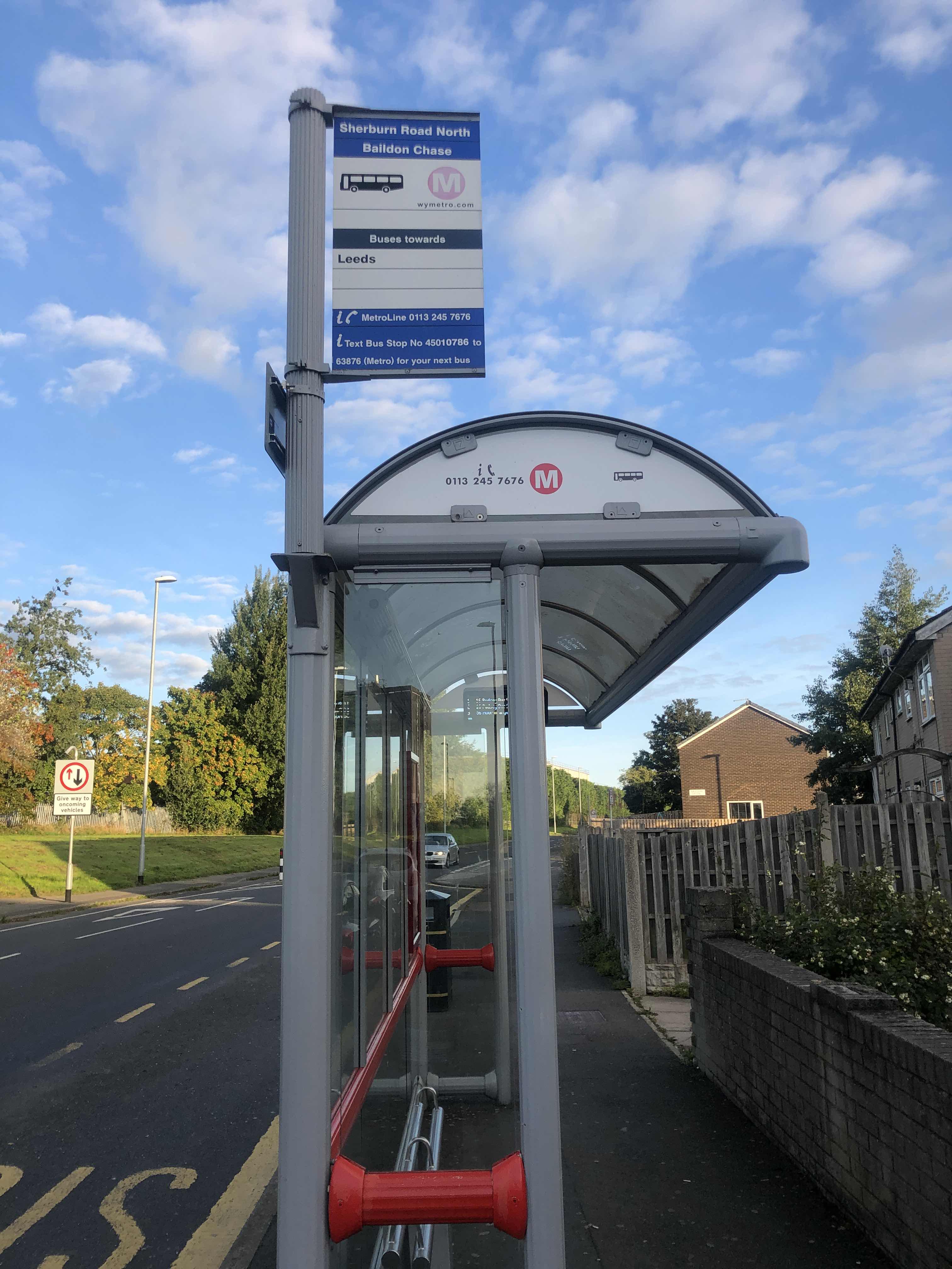 Taken by Rumbidzai N.
See Baildon Path stop, Leeds, on the map
Public transport to Baildon Path stop (ID: 45010786) in Leeds
Looking for directions to Baildon Path in Leeds, United Kingdom?
Download the Moovit App to find the current schedule and step-by-step directions for Bus or Train routes that pass through Baildon Path.
Looking for the nearest stops closest to Baildon Path ? Check out this list of closest stops to your destination: Baildon Path; Hebden Approach; Coal Road; Grimes Dike.
Bus: 16, 16A, 50, 56, 40, 7, 9C, 11, 11A, 840, 843, 875, 9.Train: NORTHERN.
We make riding on public transit to Baildon Path easy, which is why over 1.7 billion users, including users in Leeds trust Moovit as the best app for public transit.
Use the app to navigate to popular places including to the airport, hospital, stadium, grocery store, mall, coffee shop, school, college, and university.
Baildon Path stop’s code is 45010786
The first line to this stop is 16A, at 05:33, and the last line is 56 at 22:28.
Baildon Green, Leeds, England, United Kingdom
This stop serves First Leeds’s lines
- Baildon Path,
- Hebden Approach,
- Coal Road,
- Grimes Dike
Bus stops near Baildon Path stop
- Arundel Gate/Ag123,
- Orchard Lane/West Street,
- Wymersley Road,
- York Hospital,
- Doncaster,
- Mountain Mill Lane,
- The Common/Station Road,
- Bachelor Gardens,
- Victoria A,
- Worrall Road/Langsett Avenue,
- Herries Road/Norwood Avenue,
- Castle Hill Hospital,
- Mayo Avenue Morrisons,
- Clifton Gate,
- Russell Farm,
- Langdale Avenue,
- Jaunty Avenue/Jaunty Lane,
- Imphal Barracks,
- Commercial Street/Cg2,
- John Leggott College
Popular public transport stations in Leeds
Get around Leeds by public transport!
Travelling around Leeds has never been so easy. See step by step directions as you travel to any attraction, street or major public transport station. View bus and train timetables, arrival times, service alerts and detailed routes on a map, so you know exactly how to get to anywhere in Leeds.
When travelling to any destination around Leeds use Moovit's Live Directions with Get Off Notifications to know exactly where and how far to walk, how long to wait for your line , and how many stops are left. Moovit will alert you when it’s time to get off — no need to constantly re-check whether yours is the next stop.
Wondering how to use public transport in Leeds or how to pay for public transport in Leeds? Moovit public transport app can help you navigate your way with public transport easily, and at minimum cost. It includes public transport fees, ticket prices, and costs. Looking for a map of Leeds public transport lines? Moovit public transport app shows all public transport maps in Leeds with all Bus, Train and Light rail routes and stops on an interactive map.
Yorkshire has 3 transport type(s), including: Bus, Train and Light rail, operated by several transport agencies, including First Leeds, First South Yorkshire, First York, Arriva Yorkshire, Stagecoach Yorkshire, National Rail, First Bradford, First Halifax, Calder Valley & Huddersfield, East Yorkshire, The Keighley Bus Company, South Yorkshire Future Tram, The Harrogate Bus Company, TM Travel, Coastliner and Stevenson's Travel