Directions to Cannock Chase Hospital (Cannock West) with public transport
The following transport lines have routes that pass near Cannock Chase Hospital
 Bus: 60, 63, 70, 74, 875.
- Train: WEST MIDLANDS RAILWAY.
How to get to Cannock Chase Hospital by bus?
Click on the bus route to see step by step directions with maps, line arrival times and updated time schedules.
Bus stops near Cannock Chase Hospital in Cannock West
- Pye Green Road, 4 min walk,
- Bus Station, 5 min walk,
Bus lines to Cannock Chase Hospital in Cannock West
- 1, Norton Lane,
- 26, Cannock Bus Station,
- 62, Sankey's Corner,
- 63, Uttoxeter Bus Station,
- 74, Oak Avenue,
- 100, Griffin Catholic College,
- 60, Cannock Bus Station,
- X51, Old Square,
- 23, Cannock Bus Station,
- 875, Cope Street,
- 67, Cannock South - St. Peter's,
- 70, St. Peter's - Cannock South,
- 71, Essington - Cannock South,
- 3, Brownhills - Cannock South,
- 25, Cannock South,
- 817, Penkridge South East - Hednesford North,
What are the nearest stations to Cannock Chase Hospital?
The nearest stations to Cannock Chase Hospital are:
- Pye Green Road is 251 meters away, 4 min walk.
- Bus Station is 318 meters away, 5 min walk.
Which bus lines stop near Cannock Chase Hospital?
These bus lines stop near Cannock Chase Hospital: 60, 63, 70, 74, 875, X51.
Which train line stops near Cannock Chase Hospital?
WEST MIDLANDS RAILWAY (Rugeley Trent Valley)
What’s the nearest bus station to Cannock Chase Hospital in Cannock West?
The nearest bus station to Cannock Chase Hospital in Cannock West is Pye Green Road. It’s a 4 min walk away.
What time is the first bus to Cannock Chase Hospital in Cannock West?
The 60 is the first bus that goes to Cannock Chase Hospital in Cannock West. It stops nearby at 05:05.
What time is the last bus to Cannock Chase Hospital in Cannock West?
The 60 is the last bus that goes to Cannock Chase Hospital in Cannock West. It stops nearby at 00:04.
See Cannock Chase Hospital, Cannock West, on the map
Public Transit to Cannock Chase Hospital in Cannock West
Wondering how to get to Cannock Chase Hospital in Cannock West? Moovit helps you find the best way to get to Cannock Chase Hospital with step-by-step directions from the nearest public transit station.
Moovit provides free maps and live directions to help you navigate through your city. View schedules, routes, timetables, and find out how long does it take to get to Cannock Chase Hospital in real time.
Looking for the nearest stop or station to Cannock Chase Hospital? Check out this list of stops closest to your destination: Pye Green Road; Bus Station.
Bus: 60, 63, 70, 74, 875, X51, 1, 26, 62, 67, 71, 23, 3, 25, 817.Train: WEST MIDLANDS RAILWAY.
Want to see if there’s another route that gets you there at an earlier time? Moovit helps you find alternative routes or times. Get directions from and directions to Cannock Chase Hospital easily from the Moovit App or Website.
We make riding to Cannock Chase Hospital easy, which is why over 1.5 million users, including users in Cannock West, trust Moovit as the best app for public transit. You don’t need to download an individual bus app or train app, Moovit is your all-in-one transit app that helps you find the best bus time or train time available.
For information on prices of bus and train, costs and ride fares to Cannock Chase Hospital, please check the Moovit app.
Use the app to navigate to popular places including to the airport, hospital, stadium, grocery store, mall, coffee shop, school, college, and university.
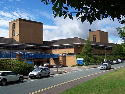
Cannock Chase Hospital Address: Brunswick Road street in Cannock West
Cannock Chase Hospital is a community hospital in Cannock Chase, Staffordshire. It is managed by Royal Wolverhampton NHS Trust.Wiki
Popular routes to Cannock Chase Hospital, Cannock West
- Ws11 5xy,
- Cannock Chase Hospital, Cannock,
- Cannock Chase Hospital - Car Park A,
- Cannock Chase District Council,
- Beecroft Clinic,
- CANNOCK JOBCENTRE,
- Holy Smoke Bar & Grill,
- A34,
- The Co-Operative Funeralcare,
- Clubbercise Brownhills & Cannock with Carrie,
- Preston Plumbing & Heating,
- Job Centre,
- Cannock Town Centre Bus Station,
- Cannock Bus Station,
- Cannock Chase Leisure Centre,
- Vape World,
- Cannock Cemetery,
- Maymies Night Club,
- Taxi Rank,
- Cannock Shopping Centre
Places Near Cannock Chase Hospital (Cannock West)
- Birmingham And Midland Eye Centre, Soho & Jewellery Quarter,
- Heritage Building (Queen Elizabeth Hospital), Edgbaston,
- Stratford Road, Sparkhill,
- Moseley, Moseley,
- Birmingham Dental Hospital, Edgbaston,
- Fort Shopping Centre, Birmingham, Pype Hayes,
- The Merry Hill Centre, Brierley Hill,
- Tally Ho Police Training, Birmingham, Edgbaston,
- IKEA Wednesbury, Oldbury,
- Bickerstaff Endoscopy Unit (PRH), Apley Castle,
- Travelodge Birmingham Airport Hotel Birmingham, Bickenhill,
- Lilleshall Hall National Sports Centre, Telford,
- Queen Elizabeth Hospital (Stop QC), Birmingham, Edgbaston,
- Bournville Staff Shop (Cadbury World), Bournville & Cotteridge,
- One Stop Shopping Centre, Perry Barr,
- Sandwell General Hospital, West Bromwich Central,
- Birmingham Heartlands Hospital, Heartlands,
- Royal Orthopaedic Hospital, Northfield,
- Crown Wharf Retail Park, St. Matthew's,
- Wolstanton Retail Park, Wolstanton
How to get to popular places in West Midlands with public transport
Get around Cannock West by public transport!
Travelling around Cannock West has never been so easy. See step by step directions as you travel to any attraction, street or major public transport station. View bus and train timetables, arrival times, service alerts and detailed routes on a map, so you know exactly how to get to anywhere in Cannock West.
When travelling to any destination around Cannock West use Moovit's Live Directions with Get Off Notifications to know exactly where and how far to walk, how long to wait for your line , and how many stops are left. Moovit will alert you when it’s time to get off — no need to constantly re-check whether yours is the next stop.
Wondering how to use public transport in Cannock West or how to pay for public transport in Cannock West? Moovit public transport app can help you navigate your way with public transport easily, and at minimum cost. It includes public transport fees, ticket prices, and costs. Looking for a map of Cannock West public transport lines? Moovit public transport app shows all public transport maps in Cannock West with all Bus, Train and Light rail routes and stops on an interactive map.
West Midlands has 3 transport type(s), including: Bus, Train and Light rail, operated by several transport agencies, including National Express West Midlands, National Express Coventry, National Express, Diamond Bus, Arriva Midlands, Stagecoach Midlands, West Midlands Metro, Stagecoach West, Stagecoach South Wales, First Potteries, First Worcestershire, LandFlight, trentbarton, D & G Bus and Flexibus