Chartists Way stop - Tuesday schedule
| Line | Direction | Time |
|---|---|---|
| 47 | Leeds Corn Exchange | 06:48 |
| 201 | Market Place H5 | 06:49 |
| 213 | Batley Bus Station | 07:26 |
| 201 | Market Place H5 | 07:39 |
| 47 | Leeds Corn Exchange | 07:56 |
| 201 | Market Place H5 | 08:09 |
| 213 | Dewsbury Bus Stn | 08:26 |
| 201 | Market Place H5 | 08:42 |
| 47 | Leeds Corn Exchange | 08:54 |
| 201 | Market Place H5 | 09:12 |
| 213 | Dewsbury Bus Stn | 09:36 |
| 201 | Market Place H5 | 09:42 |
| 47 | Leeds Corn Exchange | 09:56 |
| 201 | Market Place H5 | 10:12 |
| 213 | Dewsbury Bus Stn | 10:36 |
| 201 | Market Place H5 | 10:42 |
| 47 | Leeds Corn Exchange | 10:58 |
| 201 | Market Place H5 | 11:12 |
| 213 | Dewsbury Bus Stn | 11:36 |
| 201 | Market Place H5 | 11:42 |
| 47 | Leeds Corn Exchange | 11:56 |
| 201 | Market Place H5 | 12:12 |
| 213 | Dewsbury Bus Stn | 12:36 |
| 201 | Market Place H5 | 12:42 |
| 47 | Leeds Corn Exchange | 12:55 |
Directions to Chartists Way stop (Morley) with public transport
The following transport lines have routes that pass near Chartists Way
 Bus: 200, 201, 205, 425, 51.
- Train: NORTHERN.
How to get to Chartists Way stop by bus?
Click on the bus route to see step by step directions with maps, line arrival times and updated time schedules.
How to get to Chartists Way stop by train?
Click on the train route to see step by step directions with maps, line arrival times and updated time schedules.
Bus stops near Chartists Way stop in Morley
- Chartists Way, 1 min walk,
- Weavers Close, 2 min walk,
- Queensway, 6 min walk,
Bus lines to Chartists Way stop in Morley
- 47, Leeds - Morley,
- 52, Morley - Leeds,
- 200, Heckmondwike - Leeds,
- 201, Leeds - Heckmondwike,
- 213, Heckmondwike,
- 65, Morley Town Hall,
- 205, Dewsbury Bus Station Stand 9,
- 425, Interchange,
- 51, Victoria D,
- 47A, Leeds Corn Exchange,
What are the nearest stations to Chartists Way?
The nearest stations to Chartists Way are:
- Chartists Way stop is 12 meters away, 1 min walk.
- Weavers Close stop is 121 meters away, 2 min walk.
- Queensway stop is 431 meters away, 6 min walk.
Which bus lines stop near Chartists Way?
These bus lines stop near Chartists Way: 200, 201, 205, 425, 51, 65.
Which train line stops near Chartists Way?
NORTHERN (Bradford Interchange)
What’s the nearest bus station to Chartists Way in Morley?
The nearest bus station to Chartists Way in Morley is Chartists Way. It’s a 1 min walk away.
What time is the first bus to Chartists Way in Morley?
The 52 is the first bus that goes to Chartists Way in Morley. It stops nearby at 05:02.
What time is the last bus to Chartists Way in Morley?
The 51 is the last bus that goes to Chartists Way in Morley. It stops nearby at 00:03.
Chartists Way station
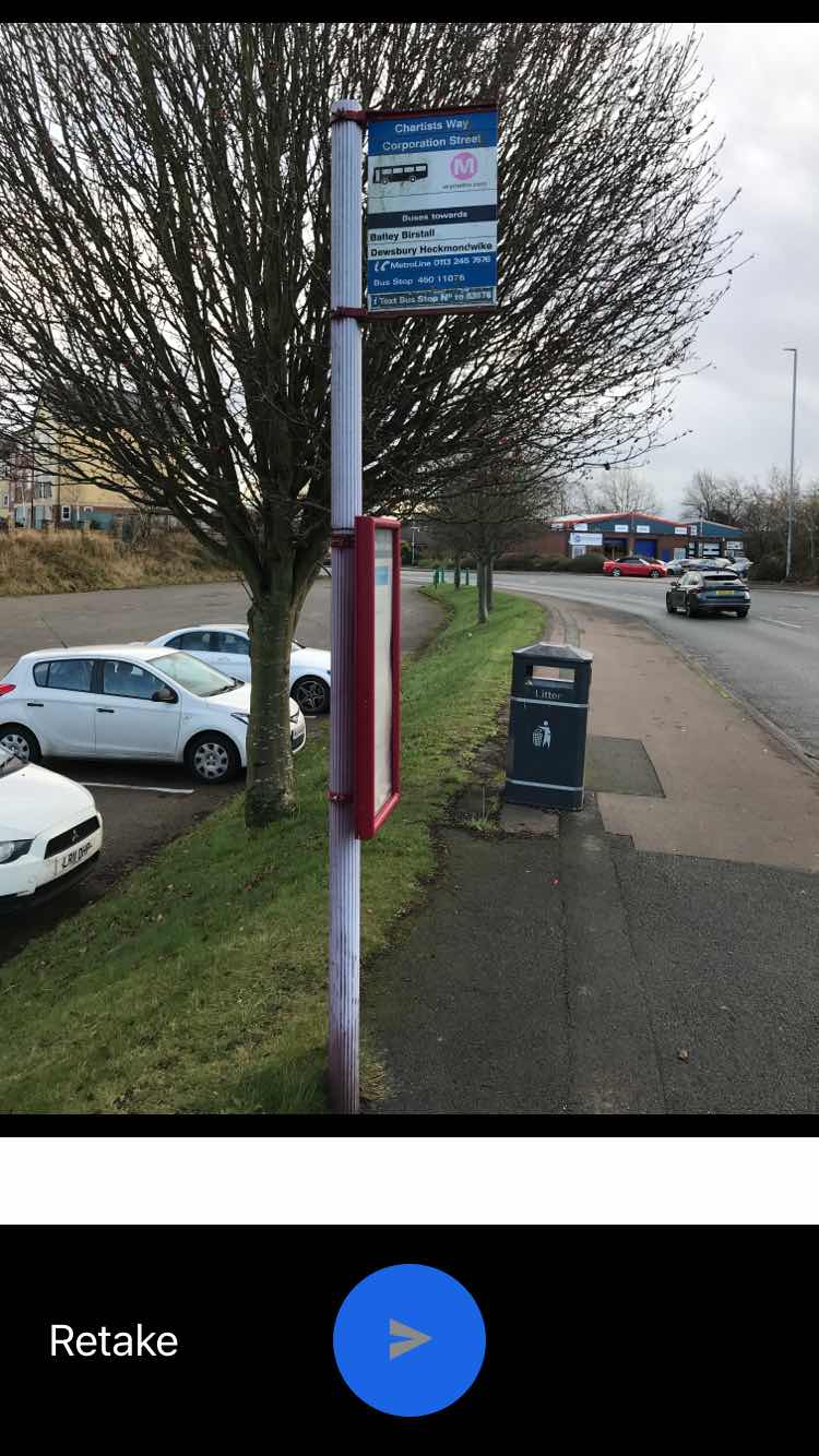 Taken by Luke J.
See Chartists Way stop, Morley, on the map
Public transport to Chartists Way stop (ID: 45011076) in Morley
Looking for directions to Chartists Way in Morley, United Kingdom?
Download the Moovit App to find the current schedule and step-by-step directions for Bus or Train routes that pass through Chartists Way.
Looking for the nearest stops closest to Chartists Way ? Check out this list of closest stops to your destination: Chartists Way; Weavers Close; Queensway.
Bus: 200, 201, 205, 425, 51, 65, 47, 52, 213, 47A.Train: NORTHERN.
We make riding on public transit to Chartists Way easy, which is why over 1.7 billion users, including users in Morley trust Moovit as the best app for public transit.
Use the app to navigate to popular places including to the airport, hospital, stadium, grocery store, mall, coffee shop, school, college, and university.
Chartists Way stop’s code is 45011076
The first line to this stop is 47, at 06:48, and the last line is 201 at 23:57.
This stop serves East Yorkshire, Arriva Yorkshire and First Leeds’s lines
- Chartists Way,
- Weavers Close,
- Queensway
Bus stops near Chartists Way stop
- Stalybridge,
- Wesley Road,
- Bents Road/Ecclesall Road South,
- Commercial Street/Cg2,
- Flat Street/Fitzalan Square,
- Elland Hospital,
- Charter Row/Moorhead Mh5,
- Penistone Road/Burnell Road,
- The Springs B,
- Peasholme Green,
- War Memorial Hospital,
- Arriva Bus Depot,
- Marston Business Park,
- Beacon Hill Rd Southowram Bank,
- Prince Of Wales Road/Motehall Road,
- Lovell Park,
- Main Street/Salt Box Lane,
- Shipley,
- Park Street/Market Place,
- Lound Side/Market Place
Popular public transport stations in Morley
Get around Morley by public transport!
Travelling around Morley has never been so easy. See step by step directions as you travel to any attraction, street or major public transport station. View bus and train timetables, arrival times, service alerts and detailed routes on a map, so you know exactly how to get to anywhere in Morley.
When travelling to any destination around Morley use Moovit's Live Directions with Get Off Notifications to know exactly where and how far to walk, how long to wait for your line , and how many stops are left. Moovit will alert you when it’s time to get off — no need to constantly re-check whether yours is the next stop.
Wondering how to use public transport in Morley or how to pay for public transport in Morley? Moovit public transport app can help you navigate your way with public transport easily, and at minimum cost. It includes public transport fees, ticket prices, and costs. Looking for a map of Morley public transport lines? Moovit public transport app shows all public transport maps in Morley with all Bus, Train and Light rail routes and stops on an interactive map.
Yorkshire has 3 transport type(s), including: Bus, Train and Light rail, operated by several transport agencies, including First Leeds, First South Yorkshire, First York, Arriva Yorkshire, Stagecoach Yorkshire, National Rail, First Bradford, First Halifax, Calder Valley & Huddersfield, East Yorkshire, The Keighley Bus Company, South Yorkshire Future Tram, The Harrogate Bus Company, TM Travel, Coastliner and Stevenson's Travel