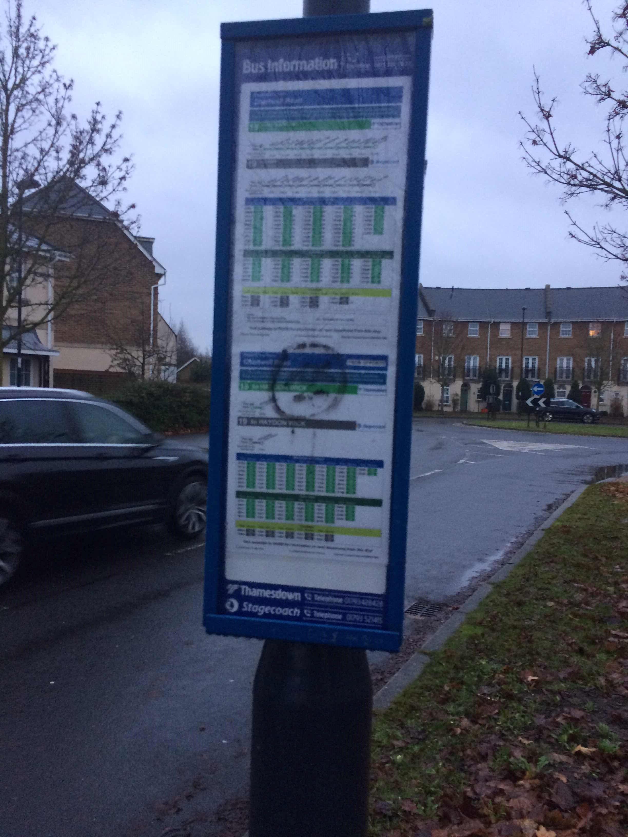
Chartwell Road stop - Sunday schedule
| Line | Direction | Time |
|---|---|---|
| 15 | Swindon | 08:49 |
| 15 | Swindon | 09:49 |
| 11 | Taw Hill | 10:17 |
| 15 | Swindon | 10:49 |
| 11 | Taw Hill | 11:17 |
| 15 | Swindon | 11:49 |
| 11 | Taw Hill | 12:17 |
| 15 | Swindon | 12:49 |
| 11 | Taw Hill | 13:17 |
| 15 | Swindon | 13:49 |
| 11 | Taw Hill | 14:17 |
| 15 | Swindon | 14:49 |
| 11 | Taw Hill | 15:17 |
| 15 | Swindon | 15:49 |
| 11 | Taw Hill | 16:17 |
| 15 | Swindon | 16:49 |
| 11 | Taw Hill | 17:17 |
| 11 | Oakhurst | 17:47 |
| 11 | Taw Hill | 18:17 |
| 11 | Taw Hill | 18:47 |
| 11 | Taw Hill | 19:39 |
| 11 | Taw Hill | 20:34 |
Directions to Chartwell Road stop (St. Andrews) with public transport
The following transport lines have routes that pass near Chartwell Road
How to get to Chartwell Road stop by bus?
Click on the bus route to see step by step directions with maps, line arrival times and updated time schedules.
Bus stops near Chartwell Road stop in St. Andrews
- Chartwell Road, 1 min walk,
- Fenton Avenue, 4 min walk,
- Orbital Shopping Park, 10 min walk,
- Blunsdon Abbey, 11 min walk,
- Piernik Close, 11 min walk,
Bus lines to Chartwell Road stop in St. Andrews
- C3, Cirencester College Grounds,
- 11, Wichelstowe,
- 12, Orbital Shopping Pk,
- 57, Tadpole Garden Village Tadpole Cross,
- 153, Oakhurst,
- 15, Swindon,
- C2, Link Leisure Centre Link Centre,
- 5, Swindon,
- C10, Lydiard Millicent Forge Fields,
- 10, Haydon Wick Orbital Shopping Park,
- C53, Royal Wootton Bassett Swallows Mead,
- 16, Orbital Shopping Pk,
What are the nearest stations to Chartwell Road?
The nearest stations to Chartwell Road are:
- Chartwell Road is 3 meters away, 1 min walk.
- Fenton Avenue is 236 meters away, 4 min walk.
- Orbital Shopping Park is 716 meters away, 10 min walk.
- Blunsdon Abbey is 797 meters away, 11 min walk.
- Piernik Close is 825 meters away, 11 min walk.
Which bus lines stop near Chartwell Road?
These bus lines stop near Chartwell Road: 10, 15, 5.
What’s the nearest bus station to Chartwell Road in St. Andrews?
The nearest bus station to Chartwell Road in St. Andrews is Chartwell Road. It’s a 1 min walk away.
What time is the first bus to Chartwell Road in St. Andrews?
The 5 is the first bus that goes to Chartwell Road in St. Andrews. It stops nearby at 06:08.
What time is the last bus to Chartwell Road in St. Andrews?
The 5 is the last bus that goes to Chartwell Road in St. Andrews. It stops nearby at 23:25.
Chartwell Road station
 Taken by Anonymous
See Chartwell Road stop, St. Andrews, on the map
Public transport to Chartwell Road stop (ID: swimdjp) in St. Andrews
Looking for directions to Chartwell Road in St. Andrews, United Kingdom?
Download the Moovit App to find the current schedule and step-by-step directions for Bus routes that pass through Chartwell Road.
Looking for the nearest stops closest to Chartwell Road ? Check out this list of closest stops to your destination: Chartwell Road; Fenton Avenue; Orbital Shopping Park; Blunsdon Abbey; Piernik Close.
Bus: 10, 15, 5, C3, 11, 12, 57, 153, C2, C10, C53, 16.
We make riding on public transit to Chartwell Road easy, which is why over 1.5 million users, including users in St. Andrews trust Moovit as the best app for public transit.
Use the app to navigate to popular places including to the airport, hospital, stadium, grocery store, mall, coffee shop, school, college, and university.
Chartwell Road stop’s code is swimdjp
The first line to this stop is 15, at 08:49, and the last line is 11 at 20:34.
Eastbury Way, Blunsdon St. Andrew Civil Parish, England, United Kingdom
This stop serves Swindon's Bus Company and Stagecoach West’s lines
Bus stops near Chartwell Road stop
Popular public transport stations in St. Andrews
Get around St. Andrews by public transport!
Travelling around St. Andrews has never been so easy. See step by step directions as you travel to any attraction, street or major public transport station. View bus and train timetables, arrival times, service alerts and detailed routes on a map, so you know exactly how to get to anywhere in St. Andrews.
When travelling to any destination around St. Andrews use Moovit's Live Directions with Get Off Notifications to know exactly where and how far to walk, how long to wait for your line , and how many stops are left. Moovit will alert you when it’s time to get off — no need to constantly re-check whether yours is the next stop.
Wondering how to use public transport in St. Andrews or how to pay for public transport in St. Andrews? Moovit public transport app can help you navigate your way with public transport easily, and at minimum cost. It includes public transport fees, ticket prices, and costs. Looking for a map of St. Andrews public transport lines? Moovit public transport app shows all public transport maps in St. Andrews with all Bus, Train and Ferry routes and stops on an interactive map.
South West has 3 transport type(s), including: Bus, Train and Ferry, operated by several transport agencies, including National Rail, Stagecoach South, Padstow Harbour Commissioners, Royal Buses, Yeos Contracts, Bennetts, MD Coaches, Newport Bus, First Bristol, Bath & the West, First Kernow, St Mawes Ferry, First Wessex, Dorset & South Somerset, Isles of Scilly Steamship Co, Stagecoach South West and Stagecoach West