Chislehurst Station stop - Saturday schedule
| Line | Direction | Time |
|---|---|---|
| SL3 | Thamesmead | 05:09 |
| SL3 | Thamesmead | 05:24 |
| 269 | Bexleyheath, Shopping Centre | 05:34 |
| SL3 | Thamesmead | 05:39 |
| SL3 | Thamesmead | 05:54 |
| 269 | Bexleyheath, Shopping Centre | 05:54 |
| 162 | Eltham Station | 05:56 |
| 162 | Eltham Station | 05:56 |
| SL3 | Thamesmead | 06:09 |
| 269 | Bexleyheath, Shopping Centre | 06:14 |
| SL3 | Thamesmead | 06:24 |
| 162 | Eltham Station | 06:26 |
| 162 | Eltham Station | 06:26 |
| 269 | Bexleyheath, Shopping Centre | 06:33 |
| SL3 | Thamesmead | 06:39 |
| 269 | Bexleyheath, Shopping Centre | 06:49 |
| R7 | Chislehurst | 06:50 |
| SL3 | Thamesmead | 06:54 |
| 162 | Eltham Station | 06:56 |
| 162 | Eltham Station | 06:56 |
| 269 | Bexleyheath, Shopping Centre | 07:04 |
| SL3 | Thamesmead | 07:09 |
| 269 | Bexleyheath, Shopping Centre | 07:19 |
| R7 | Chislehurst | 07:20 |
| SL3 | Thamesmead | 07:24 |
Directions to Chislehurst Station (London) with public transport
The following transport lines have routes that pass near Chislehurst Station
How to get to Chislehurst Station by bus?
Click on the bus route to see step by step directions with maps, line arrival times and updated time schedules.
How to get to Chislehurst Station by train?
Click on the train route to see step by step directions with maps, line arrival times and updated time schedules.
Bus stations near Chislehurst Station in London
- Chislehurst, 2 min walk,
- Susan Wood (E), 5 min walk,
Bus lines to Chislehurst Station in London
- SOUTHEASTERN, Grove Park,
- SOUTHEASTERN, Bus Replacement: Orpington,
- R7, Chislehurst,
- 162, Eltham Station,
- 269, Bromley North,
What are the nearest stations to Chislehurst Station?
The nearest stations to Chislehurst Station are:
- Chislehurst is 101 meters away, 2 min walk.
- Susan Wood (E) is 361 meters away, 5 min walk.
Which bus lines stop near Chislehurst Station?
These bus lines stop near Chislehurst Station: 162, 269, SL3.
Which train line stops near Chislehurst Station?
SOUTHEASTERN
What’s the nearest bus stop to Chislehurst Station in London?
The nearest bus stop to Chislehurst Station in London is Chislehurst. It’s a 2 min walk away.
What time is the first train to Chislehurst Station in London?
The SOUTHEASTERN is the first train that goes to Chislehurst Station in London. It stops nearby at 07:15.
What time is the last train to Chislehurst Station in London?
The SOUTHEASTERN is the last train that goes to Chislehurst Station in London. It stops nearby at 01:23.
What time is the first bus to Chislehurst Station in London?
The 269 is the first bus that goes to Chislehurst Station in London. It stops nearby at 05:31.
What time is the last bus to Chislehurst Station in London?
The 269 is the last bus that goes to Chislehurst Station in London. It stops nearby at 01:05.
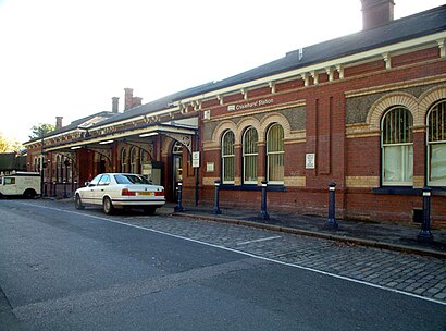
See Chislehurst Station, London, on the map
Public transport to Chislehurst Station stop (ID: A) in London
Looking for directions to Chislehurst Station in London, United Kingdom?
Download the Moovit App to find the current schedule and step-by-step directions for Bus or Train routes that pass through Chislehurst Station.
Looking for the nearest stops closest to Chislehurst Station ? Check out this list of closest stops to your destination: Chislehurst; Susan Wood (E).
Bus: 162, 269, SL3, SOUTHEASTERN, SOUTHEASTERN, R7.Train: SOUTHEASTERN.
We make riding on public transit to Chislehurst Station easy, which is why over 1.5 million users, including users in London trust Moovit as the best app for public transit.
Use the app to navigate to popular places including to the airport, hospital, stadium, grocery store, mall, coffee shop, school, college, and university.
Chislehurst Station stop’s code is A
The first line to this stop is SL3, at 05:09, and the last line is 162 at 00:51.
This stop serves London Buses’s lines
Popular public transport stations in London
Stepney Green,St Peter's Hospital, Chertsey South,Berkhamsted,Hounslow West,Crematorium, Easthampstead Park,Enfield Lock Station,Shepherd's Bush Market,Bond Street,Brentford,Tessa Jowell Health Centre,Rangers Gate, Windsor Great Park,Gipsy Hill,Amazon Lcy3, Dartford,East Ham,Dover Priory,Barons Court,Slade Green,Mascalls Academy Grounds, Paddock Wood,Victoria Station,East Croydon Tram StopGet around London by public transport!
Travelling around London has never been so easy. See step by step directions as you travel to any attraction, street or major public transport station. View bus and train timetables, arrival times, service alerts and detailed routes on a map, so you know exactly how to get to anywhere in London.
When travelling to any destination around London use Moovit's Live Directions with Get Off Notifications to know exactly where and how far to walk, how long to wait for your line , and how many stops are left. Moovit will alert you when it’s time to get off — no need to constantly re-check whether yours is the next stop.
Wondering how to use public transport in London or how to pay for public transport in London? Moovit public transport app can help you navigate your way with public transport easily, and at minimum cost. It includes public transport fees, ticket prices, and costs. Looking for a map of London public transport lines? Moovit public transport app shows all public transport maps in London with all Bus, Train, Tube, Tramlink, River Bus and DLR routes and stops on an interactive map.
London has 6 transport type(s), including: Bus, Train, Tube, Tramlink, River Bus and DLR, operated by several transport agencies, including London Underground, London Buses, Transport for London, London Tramlink, National Rail, Bluestar, Berry's Coaches, Oxford Bus Company, Stagecoach West, Community First Wessex, Cresta Coaches, D & P Boat Hire, First Portsmouth, Fareham & Gosport, FYTbus, IFS Cloud Cable Car