Exchange Quay stop - Monday schedule
| Line | Direction | Time |
|---|---|---|
| 53 | Cheetham Hill | 04:56 |
| 53 | Cheetham Hill | 05:50 |
| 53 | Cheetham Hill | 06:05 |
| 53 | Cheetham Hill | 06:35 |
| 53 | Cheetham Hill | 07:00 |
| 79 | Stretford | 07:08 |
| 53 | Cheetham Hill | 07:32 |
| 79 | Stretford | 08:02 |
| 53 | Cheetham Hill | 08:08 |
| 53 | Cheetham Hill | 08:38 |
| 53 | Cheetham Hill | 09:11 |
| 79 | Stretford | 09:14 |
| 53 | Cheetham Hill | 09:42 |
| 53 | Cheetham Hill | 10:12 |
| 79 | Stretford | 10:14 |
| 53 | Cheetham Hill | 10:42 |
| 53 | Cheetham Hill | 11:12 |
| 79 | Stretford | 11:14 |
| 53 | Cheetham Hill | 11:42 |
| 53 | Cheetham Hill | 12:12 |
| 79 | Stretford | 12:14 |
| 53 | Cheetham Hill | 12:42 |
| 53 | Cheetham Hill | 13:12 |
| 79 | Stretford | 13:14 |
| 53 | Cheetham Hill | 13:41 |
See Exchange Quay, Salford, on the map
Directions to Exchange Quay (Salford) with public transport
The following transport lines have routes that pass near Exchange Quay
 Bus:
Bus: - Train:
- Light rail:
How to get to Exchange Quay by bus?
Click on the bus route to see step by step directions with maps, line arrival times and updated time schedules.
How to get to Exchange Quay by train?
Click on the train route to see step by step directions with maps, line arrival times and updated time schedules.
How to get to Exchange Quay by light rail?
Click on the light rail route to see step by step directions with maps, line arrival times and updated time schedules.
Bus stations near Exchange Quay in Salford
- Clippers Quay,2 min walk,
- White City,3 min walk,
- Trafford Road,8 min walk,
- Matt Busby Way,10 min walk,
Light Rail stations near Exchange Quay in Salford
- Exchange Quay (Manchester Metrolink),2 min walk,
- Wharfside (Manchester Metrolink),7 min walk,
Bus lines to Exchange Quay in Salford
- 53,Cheetham Hill,
- 79,Pendleton,
- 745,Roe Green,
- 263,Altrincham,
- 255,Partington,
- 256,Flixton,
- X50,Worsley,
- 250,Piccadilly Gardens,
What are the nearest stations to Exchange Quay?
The nearest stations to Exchange Quay are:
- Clippers Quay is 111 meters away, 2 min walk.
- Exchange Quay (Manchester Metrolink) is 129 meters away, 2 min walk.
- White City is 192 meters away, 3 min walk.
- Trafford Road is 499 meters away, 8 min walk.
- Wharfside (Manchester Metrolink) is 499 meters away, 7 min walk.
- Matt Busby Way is 691 meters away, 10 min walk.
Which bus lines stop near Exchange Quay?
These bus lines stop near Exchange Quay: 53, X50.
Which train line stops near Exchange Quay?
NORTHERN
Which light rail line stops near Exchange Quay?
BLUE LINE
What’s the nearest light rail station to Exchange Quay in Salford?
The nearest light rail station to Exchange Quay in Salford is Exchange Quay (Manchester Metrolink). It’s a 2 min walk away.
What’s the nearest bus stop to Exchange Quay in Salford?
The nearest bus stop to Exchange Quay in Salford is Clippers Quay. It’s a 2 min walk away.
What time is the first light rail to Exchange Quay in Salford?
The RED LINE is the first light rail that goes to Exchange Quay in Salford. It stops nearby at 05:24.
What time is the last light rail to Exchange Quay in Salford?
The RED LINE is the last light rail that goes to Exchange Quay in Salford. It stops nearby at 00:37.
What time is the first bus to Exchange Quay in Salford?
The 53 is the first bus that goes to Exchange Quay in Salford. It stops nearby at 04:54.
What time is the last bus to Exchange Quay in Salford?
The 256 is the last bus that goes to Exchange Quay in Salford. It stops nearby at 00:47.
How much is the train fare to Exchange Quay?
The train fare to Exchange Quay costs about £3.40.
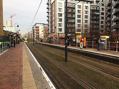
Exchange Quay station
 Taken by Anonymous
See Exchange Quay, Salford, on the map
Public transport to Exchange Quay stop (ID: MANGMJTM) in Salford
Looking for directions to Exchange Quay in Salford, United Kingdom?
Download the Moovit App to find the current schedule and step-by-step directions for Light rail, Bus or Train routes that pass through Exchange Quay.
Looking for the nearest stops closest to Exchange Quay ? Check out this list of closest stops to your destination: Clippers Quay; Exchange Quay (Manchester Metrolink); White City; Trafford Road; Wharfside (Manchester Metrolink); Matt Busby Way.
Bus:Train:Light rail:
We make riding on public transit to Exchange Quay easy, which is why over 1.5 million users, including users in Salford trust Moovit as the best app for public transit.
Use the app to navigate to popular places including to the airport, hospital, stadium, grocery store, mall, coffee shop, school, college, and university.
Exchange Quay stop’s code is MANGMJTM
The first line to this stop is 53, at 04:56, and the last line is 53 at 22:55.
Exchange Quay, Salford, England, United Kingdom
This stop serves Bee Network and Bee Network’s lines
Light Rail stations near Exchange Quay
Exchange Quay (Manchester Metrolink),Wharfside (Manchester Metrolink)Popular public transport stations in Salford
Birkenhead North,Manchester Airport (Manchester Metrolink),Millfield High School,Heaton Park Metrolink (Stop D),Oxford Road Station (Stop A),Mottram Junction (Stop A),St Peter's Square (Manchester Metrolink),Devonshire Street,Seymour Road,Market Street,Platts Lane,Whitley Crescent,Hooton,Burscough Bridge,Fairfield General Hospital (Stop B),Zetland Street,Range High School,Imperial War Museum (Manchester Metrolink),Backford Cross Roundabout,Mossfield RoadGet around Salford by public transport!
Travelling around Salford has never been so easy. See step by step directions as you travel to any attraction, street or major public transport station. View bus and train timetables, arrival times, service alerts and detailed routes on a map, so you know exactly how to get to anywhere in Salford.
When travelling to any destination around Salford use Moovit's Live Directions with Get Off Notifications to know exactly where and how far to walk, how long to wait for your line , and how many stops are left. Moovit will alert you when it’s time to get off — no need to constantly re-check whether yours is the next stop.
Wondering how to use public transport in Salford or how to pay for public transport in Salford? Moovit public transport app can help you navigate your way with public transport easily, and at minimum cost. It includes public transport fees, ticket prices, and costs. Looking for a map of Salford public transport lines? Moovit public transport app shows all public transport maps in Salford with all light rail, bus or train routes and stops on an interactive map.
Salford has 3 transport type(s), including: light rail, bus or train, operated by several transport agencies, including Stagecoach Manchester, Arriva North West, Diamond Bus North West, Stagecoach Merseyside and South Lancashire, Stagecoach Cumbria and North Lancashire, First Greater Manchester, First Halifax, National Express, Warrington's Own Buses, First Potteries, Rosso, Blackpool Transport, Blackpool Transport, The Blackburn Bus Company and The Burnley Bus Company