Farsley Library stop - Sunday schedule
| Line | Direction | Time |
|---|---|---|
| 16A | Pudsey Bus Station | 06:43 |
| 16 | Pudsey Bus Station | 07:14 |
| 16A | Pudsey Bus Station | 07:38 |
| 16 | Pudsey Bus Station | 08:08 |
| 16A | Pudsey Bus Station | 08:34 |
| 16 | Pudsey Bus Station | 09:00 |
| 16A | Pudsey Bus Station | 09:30 |
| 16 | Pudsey Bus Station | 09:58 |
| 16A | Pudsey Bus Station | 10:28 |
| 16 | Pudsey Bus Station | 10:58 |
| 16A | Pudsey Bus Station | 11:27 |
| 16 | Pudsey Bus Station | 11:56 |
| 16A | Pudsey Bus Station | 12:25 |
| 16 | Pudsey Bus Station | 12:50 |
| 16A | Pudsey Bus Station | 13:18 |
| 16 | Pudsey Bus Station | 13:44 |
| 16A | Pudsey Bus Station | 14:10 |
| 16 | Pudsey Bus Station | 14:38 |
| 16A | Pudsey Bus Station | 15:02 |
| 16 | Pudsey Bus Station | 15:28 |
| 16A | Pudsey Bus Station | 15:53 |
| 16 | Pudsey Bus Station | 16:20 |
| 16A | Pudsey Bus Station | 16:43 |
| 16 | Pudsey Bus Station | 17:13 |
| 16A | Pudsey Bus Station | 17:39 |
Directions to Farsley Library stop (Leeds) with public transport
The following transport lines have routes that pass near Farsley Library
 Bus: 16, 16A, 508, 72, 9C.
- Train: NORTHERN.
How to get to Farsley Library stop by bus?
Click on the bus route to see step by step directions with maps, line arrival times and updated time schedules.
How to get to Farsley Library stop by train?
Click on the train route to see step by step directions with maps, line arrival times and updated time schedules.
Bus stops near Farsley Library stop in Leeds
- Farsley Library, 1 min walk,
- St John's Church, 3 min walk,
- New Street, 7 min walk,
Bus lines to Farsley Library stop in Leeds
- 9C, Station Road Troy Road,
- 16, Whinmoor Shop Ctr,
- 16A, Pudsey Bus Station,
- 80, Old Farnley,
- 9, Ring Road Lower Wortley,
- 72, Eastgate E3,
What are the nearest stations to Farsley Library?
The nearest stations to Farsley Library are:
- Farsley Library stop is 63 meters away, 1 min walk.
- St John's Church stop is 180 meters away, 3 min walk.
- New Street stop is 523 meters away, 7 min walk.
Which bus lines stop near Farsley Library?
These bus lines stop near Farsley Library: 16, 16A, 508, 72.
Which train line stops near Farsley Library?
NORTHERN (Leeds)
What’s the nearest bus station to Farsley Library in Leeds?
The nearest bus station to Farsley Library in Leeds is Farsley Library. It’s a 1 min walk away.
What time is the first bus to Farsley Library in Leeds?
The 72 is the first bus that goes to Farsley Library in Leeds. It stops nearby at 03:20.
What time is the last bus to Farsley Library in Leeds?
The 72 is the last bus that goes to Farsley Library in Leeds. It stops nearby at 02:28.
Farsley Library station
 Taken by Andy L.
See Farsley Library stop, Leeds, on the map
Public transport to Farsley Library stop (ID: 45012381) in Leeds
Looking for directions to Farsley Library in Leeds, United Kingdom?
Download the Moovit App to find the current schedule and step-by-step directions for Bus or Train routes that pass through Farsley Library.
Looking for the nearest stops closest to Farsley Library ? Check out this list of closest stops to your destination: Farsley Library; St John's Church; New Street.
Bus: 16, 16A, 508, 72, 9C, 80, 9.Train: NORTHERN.
We make riding on public transit to Farsley Library easy, which is why over 1.7 billion users, including users in Leeds trust Moovit as the best app for public transit.
Use the app to navigate to popular places including to the airport, hospital, stadium, grocery store, mall, coffee shop, school, college, and university.
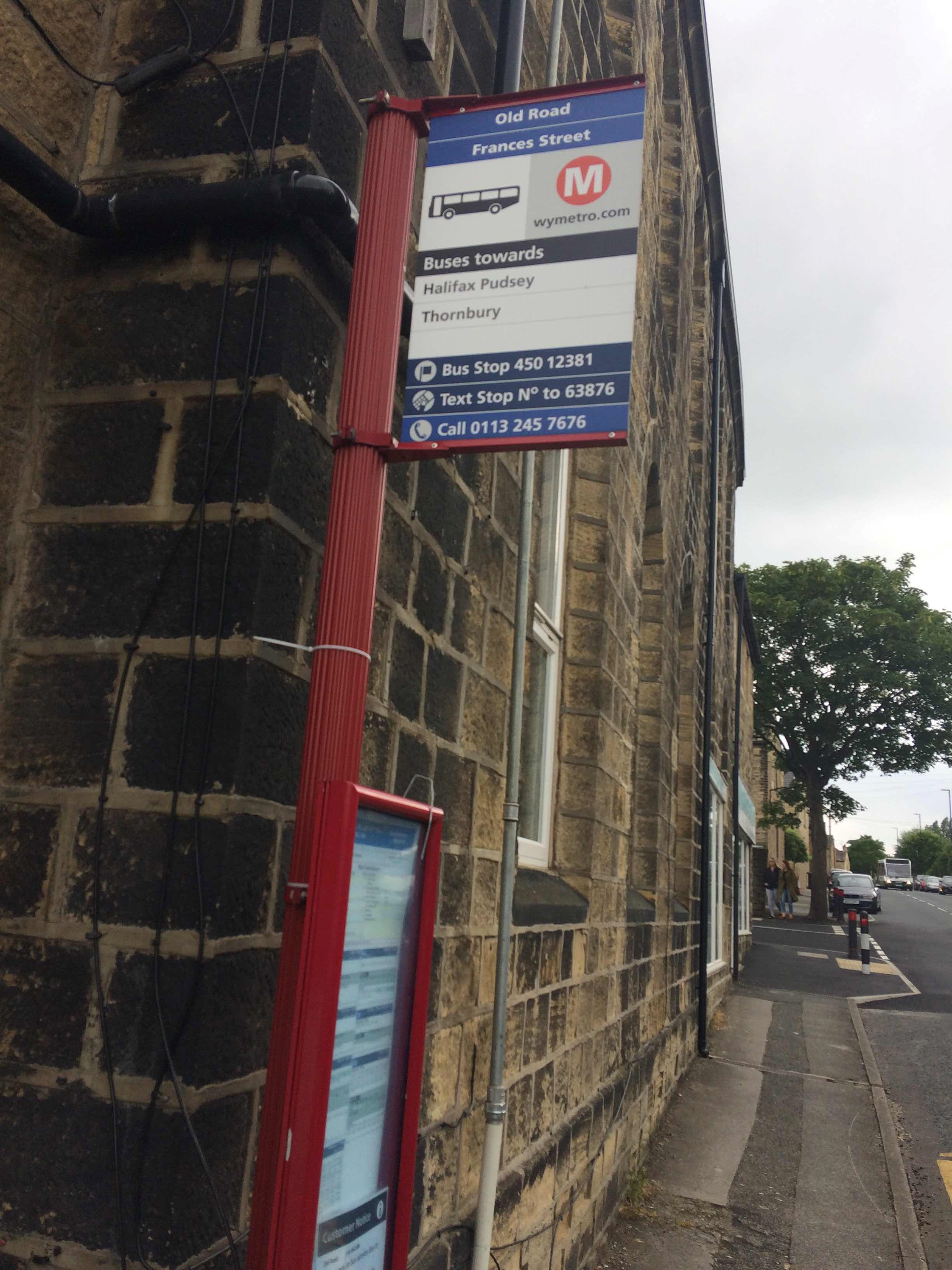
Farsley Library stop’s code is 45012381
The first line to this stop is 16A, at 06:43, and the last line is 16A at 23:37.
Old Road, Leeds, England, United Kingdom
This stop serves Squarepeg and First Leeds’s lines
Popular routes from Farsley Library stop, Leeds
- Farsley Library,
- St John's Church,
- New Street
Bus stops near Farsley Library stop
- Seacroft Hospital,
- Arundel Gate/Ag9,
- Campus East Interchange,
- Southbank C,
- Huddersfield Road Bretton Country Park,
- Beverley Road Tesco,
- Clare Hill,
- Roundhay Road Tesco,
- Walkley Road/Walkley Bank Road,
- Salt Box Lane/Greno Crescent,
- West Square Stop V,
- Derbyshire Lane/Cliffefield Road,
- Longley Lane/Longley Hall Road,
- Ash Hill Road/Ash Hill Academy,
- Asda,
- St George's Square S2,
- Castleford College,
- Low Moor,
- Harehills Avenue,
- Mirfield
Popular public transport stations in Leeds
Get around Leeds by public transport!
Travelling around Leeds has never been so easy. See step by step directions as you travel to any attraction, street or major public transport station. View bus and train timetables, arrival times, service alerts and detailed routes on a map, so you know exactly how to get to anywhere in Leeds.
When travelling to any destination around Leeds use Moovit's Live Directions with Get Off Notifications to know exactly where and how far to walk, how long to wait for your line , and how many stops are left. Moovit will alert you when it’s time to get off — no need to constantly re-check whether yours is the next stop.
Wondering how to use public transport in Leeds or how to pay for public transport in Leeds? Moovit public transport app can help you navigate your way with public transport easily, and at minimum cost. It includes public transport fees, ticket prices, and costs. Looking for a map of Leeds public transport lines? Moovit public transport app shows all public transport maps in Leeds with all Bus, Train and Light rail routes and stops on an interactive map.
Yorkshire has 3 transport type(s), including: Bus, Train and Light rail, operated by several transport agencies, including First Leeds, First South Yorkshire, First York, Arriva Yorkshire, Stagecoach Yorkshire, National Rail, First Bradford, First Halifax, Calder Valley & Huddersfield, East Yorkshire, The Keighley Bus Company, South Yorkshire Future Tram, The Harrogate Bus Company, TM Travel, Coastliner and Stevenson's Travel