Fifty Steps stop - Sunday schedule
| Line | Direction | Time |
|---|---|---|
| 383 | Marsden Dirker | 06:28 |
| 383 | Marsden Dirker | 06:28 |
| 383 | Marsden Dirker | 07:28 |
| 383 | Marsden Dirker | 07:28 |
| 383 | Marsden Dirker | 08:28 |
| 383 | Marsden Dirker | 08:28 |
| 184 | Oldham Bus Station | 08:39 |
| 383 | Marsden Dirker | 09:28 |
| 383 | Marsden Dirker | 09:28 |
| 303 | Scapegoat Hill | 09:46 |
| 383 | Marsden Dirker | 10:29 |
| 383 | Marsden Dirker | 10:29 |
| 382 | Wilberlee | 10:36 |
| 382 | Wilberlee | 10:36 |
| 184 | Oldham Bus Station | 10:39 |
| 303 | Scapegoat Hill | 10:46 |
| 383 | Marsden Dirker | 11:29 |
| 383 | Marsden Dirker | 11:29 |
| 396 | Wilberlee | 11:45 |
| 383 | Marsden Dirker | 12:29 |
| 383 | Marsden Dirker | 12:29 |
| 382 | Wilberlee | 12:36 |
| 382 | Wilberlee | 12:36 |
| 184 | Oldham Bus Station | 12:39 |
| 303 | Scapegoat Hill | 12:46 |
Directions to Fifty Steps stop (Huddersfield) with public transport
The following transport lines have routes that pass near Fifty Steps
 Bus: 303, 383, 184, 304, 382.
- Train: NORTHERN.
How to get to Fifty Steps stop by bus?
Click on the bus route to see step by step directions with maps, line arrival times and updated time schedules.
How to get to Fifty Steps stop by train?
Click on the train route to see step by step directions with maps, line arrival times and updated time schedules.
Bus stops near Fifty Steps stop in Huddersfield
- Fifty Steps, 1 min walk,
- Park Road, 6 min walk,
- Lowergate, 18 min walk,
Bus lines to Fifty Steps stop in Huddersfield
- 184, Bus Station,
- 303, Scapegoat Hill,
- 304, Huddersfield Busstn,
- 382, Huddersfield Busstn,
- 383, Marsden Dirker,
- 394, Tudor Street,
- 395, Tudor Street,
- 396, Huddersfield Busstn,
- 328, Bradley Alandale Rd,
- 393, Stand O Huddersfield Bus Station,
- 387, Huddersfield Busstn,
- 356, Longwood,
What are the nearest stations to Fifty Steps?
The nearest stations to Fifty Steps are:
- Fifty Steps stop is 35 meters away, 1 min walk.
- Park Road stop is 450 meters away, 6 min walk.
- Lowergate stop is 1404 meters away, 18 min walk.
Which bus lines stop near Fifty Steps?
These bus lines stop near Fifty Steps: 303, 383.
Which train line stops near Fifty Steps?
NORTHERN (Lockwood)
What’s the nearest bus station to Fifty Steps in Huddersfield?
The nearest bus station to Fifty Steps in Huddersfield is Fifty Steps. It’s a 1 min walk away.
What time is the first bus to Fifty Steps in Huddersfield?
The 383 is the first bus that goes to Fifty Steps in Huddersfield. It stops nearby at 06:27.
What time is the last bus to Fifty Steps in Huddersfield?
The 383 is the last bus that goes to Fifty Steps in Huddersfield. It stops nearby at 23:24.
Fifty Steps station
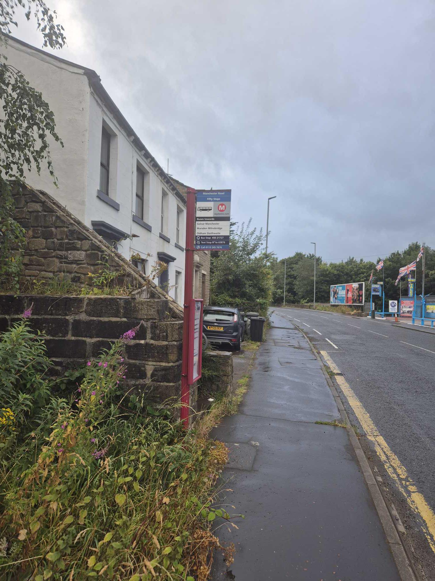 Taken by Anonymous
See Fifty Steps stop, Huddersfield, on the map
Public transport to Fifty Steps stop (ID: 45021727) in Huddersfield
Looking for directions to Fifty Steps in Huddersfield, United Kingdom?
Download the Moovit App to find the current schedule and step-by-step directions for Bus or Train routes that pass through Fifty Steps.
Looking for the nearest stops closest to Fifty Steps ? Check out this list of closest stops to your destination: Fifty Steps; Park Road; Lowergate.
Bus: 303, 383, 184, 304, 382, 328, 393, 387, 356, 356.Train: NORTHERN.
We make riding on public transit to Fifty Steps easy, which is why over 1.7 billion users, including users in Huddersfield trust Moovit as the best app for public transit.
Use the app to navigate to popular places including to the airport, hospital, stadium, grocery store, mall, coffee shop, school, college, and university.
Fifty Steps stop’s code is 45021727
The first line to this stop is 383, at 06:28, and the last line is 383 at 23:23.
This stop serves First Halifax, Calder Valley & Huddersfield, Team Pennine, Stotts Coaches and Bee Network’s lines
- Fifty Steps,
- Park Road,
- Lowergate
Bus stops near Fifty Steps stop
- Paternoster Row/Ss2,
- Anlaby Tranby Lane,
- Laund Road,
- Kitson Hill Cresent,
- Bridge Gate,
- Howard Street/Doncaster Gate,
- Woolley Colliery Road/Bluebell Road,
- Beverley Lairgate,
- Headrow A,
- East Bawtry Road/Wickersley Road,
- Dick Lane Junction,
- Station C,
- Highgreave/High Greave Avenue,
- Harehills Avenue,
- Retford,
- Holgate Avenue/Holgate Crescent,
- Arundel Gate/Ag9,
- Bradford Forster Square,
- Rawson Square H,
- Castle Hill Hospital
Popular public transport stations in Huddersfield
Get around Huddersfield by public transport!
Travelling around Huddersfield has never been so easy. See step by step directions as you travel to any attraction, street or major public transport station. View bus and train timetables, arrival times, service alerts and detailed routes on a map, so you know exactly how to get to anywhere in Huddersfield.
When travelling to any destination around Huddersfield use Moovit's Live Directions with Get Off Notifications to know exactly where and how far to walk, how long to wait for your line , and how many stops are left. Moovit will alert you when it’s time to get off — no need to constantly re-check whether yours is the next stop.
Wondering how to use public transport in Huddersfield or how to pay for public transport in Huddersfield? Moovit public transport app can help you navigate your way with public transport easily, and at minimum cost. It includes public transport fees, ticket prices, and costs. Looking for a map of Huddersfield public transport lines? Moovit public transport app shows all public transport maps in Huddersfield with all Bus, Train and Light rail routes and stops on an interactive map.
Yorkshire has 3 transport type(s), including: Bus, Train and Light rail, operated by several transport agencies, including First Leeds, First South Yorkshire, First York, Arriva Yorkshire, Stagecoach Yorkshire, National Rail, First Bradford, First Halifax, Calder Valley & Huddersfield, East Yorkshire, The Keighley Bus Company, South Yorkshire Future Tram, The Harrogate Bus Company, TM Travel, Coastliner and Stevenson's Travel