Frederick Rd stop - Saturday schedule
| Line | Direction | Time |
|---|---|---|
| 907 | Gracechurch Centre | 06:11 |
| 907 | Gracechurch Centre | 06:11 |
| 5 | Gracechurch Centre | 06:18 |
| 5 | Gracechurch Centre | 06:18 |
| 907 | Gracechurch Centre | 06:42 |
| 907 | Gracechurch Centre | 06:42 |
| 5 | Gracechurch Centre | 06:51 |
| 5 | Gracechurch Centre | 06:51 |
| 907 | Gracechurch Centre | 07:21 |
| 907 | Gracechurch Centre | 07:21 |
| 5 | Gracechurch Centre | 07:21 |
| 5 | Gracechurch Centre | 07:21 |
| 5 | Gracechurch Centre | 07:51 |
| 5 | Gracechurch Centre | 07:51 |
| 907 | Gracechurch Centre | 07:53 |
| 907 | Gracechurch Centre | 07:53 |
| 77 | Asda Superstore | 08:07 |
| 77 | Asda Superstore | 08:07 |
| 5 | Gracechurch Centre | 08:13 |
| 5 | Gracechurch Centre | 08:13 |
| 907 | Gracechurch Centre | 08:23 |
| 907 | Gracechurch Centre | 08:23 |
| 66 | Gracechurch Centre | 08:30 |
| 66 | Gracechurch Centre | 08:30 |
| 5 | Gracechurch Centre | 08:33 |
Directions to Frederick Rd stop (Sutton Vesey) with public transport
The following transport lines have routes that pass near Frederick Rd
 Bus: 5, 907, 66, 77, 77B.
- Train: WEST MIDLANDS RAILWAY.
How to get to Frederick Rd stop by bus?
Click on the bus route to see step by step directions with maps, line arrival times and updated time schedules.
How to get to Frederick Rd stop by train?
Click on the train route to see step by step directions with maps, line arrival times and updated time schedules.
Bus stops near Frederick Rd stop in Sutton Vesey
- Buckingham Mews, 5 min walk,
- Ashdene Close, 10 min walk,
- Horse & Jockey, 12 min walk,
Bus lines to Frederick Rd stop in Sutton Vesey
- 5, West Bromwich Central - Sutton Trinity,
- 66, Ladywood - Sutton Trinity,
- 77, Sutton Trinity - St. Matthew's,
- 77B, Sutton Vesey - Sutton Walmley & Minworth,
- 77S, Sutton Reddicap - Streetly,
- 907, Sutton Trinity - Ladywood,
- 77A, Walsall Bus Station,
- X3, Stowe - Ladywood,
- X4, Sutton Reddicap - Ladywood,
- X5, Sutton Roughley - Ladywood,
- 76, Sutton Trinity - Castle,
- 110, Ladywood - Castle,
What are the nearest stations to Frederick Rd?
The nearest stations to Frederick Rd are:
- Buckingham Mews is 390 meters away, 5 min walk.
- Ashdene Close is 754 meters away, 10 min walk.
- Horse & Jockey is 872 meters away, 12 min walk.
Which bus lines stop near Frederick Rd?
These bus lines stop near Frederick Rd: 5, 907.
Which train line stops near Frederick Rd?
WEST MIDLANDS RAILWAY (Four Oaks)
What’s the nearest bus station to Frederick Rd in Sutton Vesey?
The nearest bus station to Frederick Rd in Sutton Vesey is Buckingham Mews. It’s a 5 min walk away.
What time is the first bus to Frederick Rd in Sutton Vesey?
The X4 is the first bus that goes to Frederick Rd in Sutton Vesey. It stops nearby at 04:37.
What time is the last bus to Frederick Rd in Sutton Vesey?
The X4 is the last bus that goes to Frederick Rd in Sutton Vesey. It stops nearby at 01:27.
Frederick Rd station
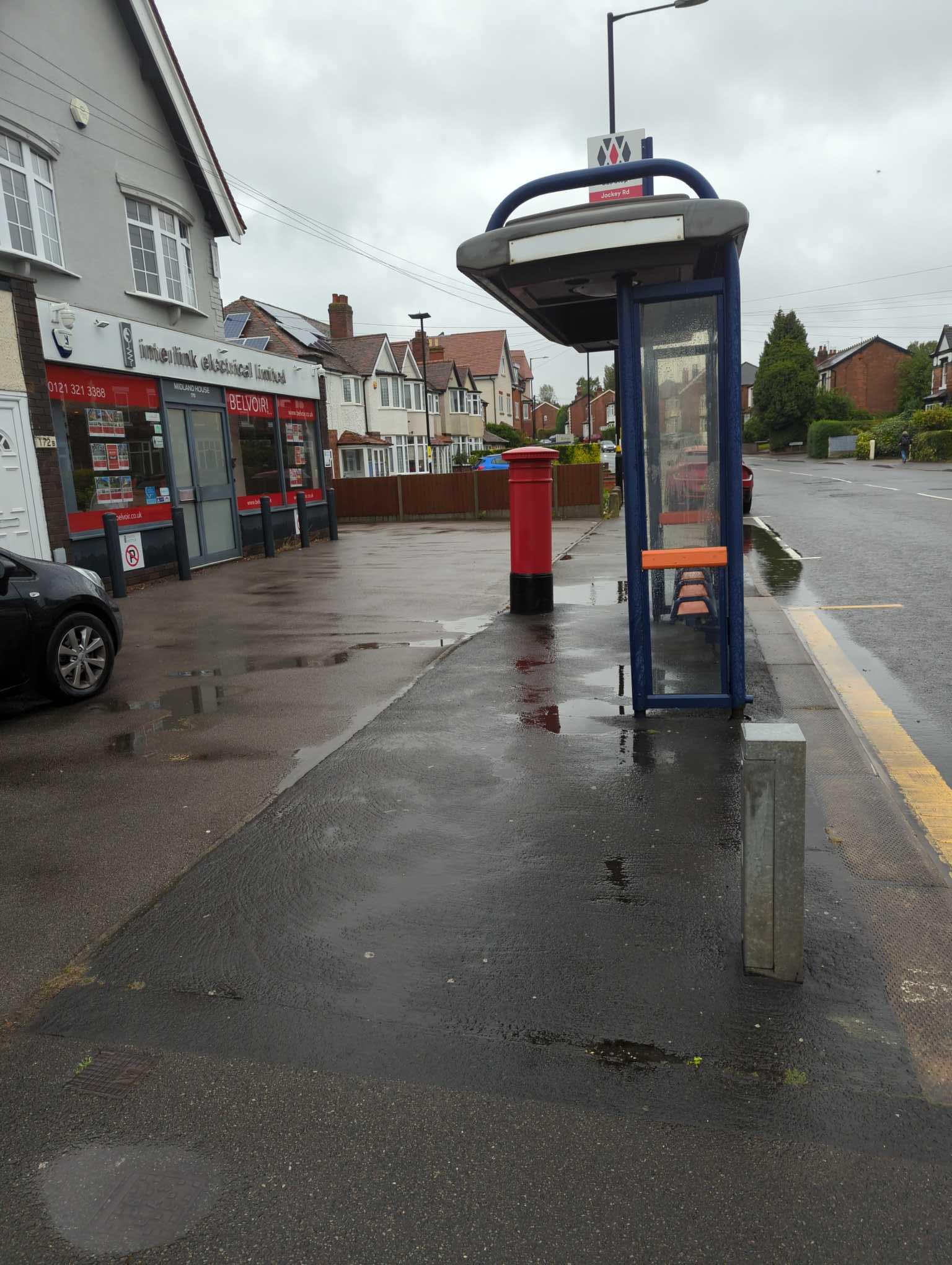 Taken by Perryn B.
See Frederick Rd stop, Sutton Vesey, on the map
Public transport to Frederick Rd stop (ID: nwmgtjgm) in Sutton Vesey
Looking for directions to Frederick Rd in Sutton Vesey, United Kingdom?
Download the Moovit App to find the current schedule and step-by-step directions for Bus, Train or Light rail routes that pass through Frederick Rd.
Looking for the nearest stops closest to Frederick Rd ? Check out this list of closest stops to your destination: Buckingham Mews; Ashdene Close; Horse & Jockey.
Bus: 5, 907, 66, 77, 77B, 77S, 77A, X3, X4, X5, 76, 110.Train: WEST MIDLANDS RAILWAY.
We make riding on public transit to Frederick Rd easy, which is why over 1.5 million users, including users in Sutton Vesey trust Moovit as the best app for public transit.
Use the app to navigate to popular places including to the airport, hospital, stadium, grocery store, mall, coffee shop, school, college, and university.
Frederick Rd stop’s code is nwmgtjgm
The first line to this stop is 907, at 06:11, and the last line is 907 at 00:01.
170 Jockey Road, Birmingham, England, United Kingdom
This stop serves National Express West Midlands’s lines
- Buckingham Mews,
- Ashdene Close,
- Horse & Jockey
Bus stops near Frederick Rd stop
- Old Birmingham Road,
- Smethwick Rolfe Street,
- Vicarage Street,
- Naird Roundabout,
- Hampton-In-Arden,
- Westfield Rd,
- Swan Shopping Centre,
- Stechford,
- Poplar Rd,
- Lyndon Rd,
- Bescot Stadium,
- Third Avenue,
- Prologis Park,
- Bennetts Road,
- St Johns Church,
- Jaguar Land Rover,
- Warwick Technology Park,
- Hall Green,
- Sandwell & Dudley Station,
- Nicholas Chamberlaine School
Popular public transport stations in Sutton Vesey
Get around Sutton Vesey by public transport!
Travelling around Sutton Vesey has never been so easy. See step by step directions as you travel to any attraction, street or major public transport station. View bus and train timetables, arrival times, service alerts and detailed routes on a map, so you know exactly how to get to anywhere in Sutton Vesey.
When travelling to any destination around Sutton Vesey use Moovit's Live Directions with Get Off Notifications to know exactly where and how far to walk, how long to wait for your line , and how many stops are left. Moovit will alert you when it’s time to get off — no need to constantly re-check whether yours is the next stop.
Wondering how to use public transport in Sutton Vesey or how to pay for public transport in Sutton Vesey? Moovit public transport app can help you navigate your way with public transport easily, and at minimum cost. It includes public transport fees, ticket prices, and costs. Looking for a map of Sutton Vesey public transport lines? Moovit public transport app shows all public transport maps in Sutton Vesey with all Bus, Train and Light rail routes and stops on an interactive map.
West Midlands has 3 transport type(s), including: Bus, Train and Light rail, operated by several transport agencies, including National Express West Midlands, National Express Coventry, National Express, Diamond Bus, Arriva Midlands, Stagecoach Midlands, West Midlands Metro, Stagecoach West, Stagecoach South Wales, First Potteries, First Worcestershire, LandFlight, trentbarton, D & G Bus and Flexibus