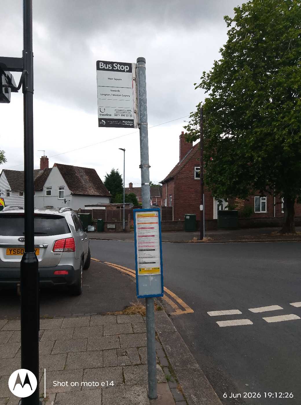
Meir Square stop - Saturday schedule
| Line | Direction | Time |
|---|---|---|
| 37 | Lymedale | 04:52 |
| 37 | Lymedale | 04:52 |
| 6 | Hanley (City Cent) | 06:42 |
| 6 | Hanley (City Cent) | 06:42 |
| 37 | Longton, the Strand [C] | 07:01 |
| 37 | Longton, the Strand [C] | 07:01 |
| 6 | Hanley (City Cent) | 07:12 |
| 6 | Hanley (City Cent) | 07:12 |
| 1A | Church Street | 07:42 |
| 6 | Hanley (City Cent) | 07:52 |
| 6 | Hanley (City Cent) | 07:52 |
| 1 | Kents Lane | 08:12 |
| 6 | Coalville | 08:13 |
| 6 | Coalville | 08:13 |
| 6 | Parkhall | 08:33 |
| 6 | Parkhall | 08:33 |
| 1A | Church Street | 08:42 |
| 6 | Hanley (City Cent) | 08:54 |
| 6 | Hanley (City Cent) | 08:54 |
| 6 | Coalville | 09:03 |
| 6 | Coalville | 09:03 |
| 6 | Hanley (City Cent) | 09:08 |
| 6 | Hanley (City Cent) | 09:08 |
| 1 | Kents Lane | 09:12 |
| 6 | Parkhall | 09:36 |
Directions to Meir Square stop (Meir North) with public transport
The following transport lines have routes that pass near Meir Square
 Bus: 6, 6A, 6C, 36, 37.
- Train: EAST MIDLANDS RAILWAY.
How to get to Meir Square stop by bus?
Click on the bus route to see step by step directions with maps, line arrival times and updated time schedules.
How to get to Meir Square stop by train?
Click on the train route to see step by step directions with maps, line arrival times and updated time schedules.
Bus stops near Meir Square stop in Meir North
- North Walk, 2 min walk,
- Brownfield Road, 4 min walk,
- Co-Op, 9 min walk,
- Broadway, 11 min walk,
Bus lines to Meir Square stop in Meir North
- 6, Longton - Hanley,
- 6C, Hanley - Longton,
- 36, Longton - Talke & Butt Lane,
- 37, Newcastle under Lyme - Longton,
- 1, Cheddar Drive,
- 1A, Church Street,
- PC8, Meir, Coop,
- 6A, Blythe Bridge,
- 36A, Meir Park, Tesco,
What are the nearest stations to Meir Square?
The nearest stations to Meir Square are:
- North Walk stop is 119 meters away, 2 min walk.
- Brownfield Road stop is 301 meters away, 4 min walk.
- Co-Op stop is 644 meters away, 9 min walk.
- Broadway stop is 807 meters away, 11 min walk.
Which bus lines stop near Meir Square?
These bus lines stop near Meir Square: 6, 6A.
Which train line stops near Meir Square?
EAST MIDLANDS RAILWAY (Derby)
What’s the nearest bus station to Meir Square in Meir North?
The nearest bus station to Meir Square in Meir North is North Walk. It’s a 2 min walk away.
What time is the first bus to Meir Square in Meir North?
The 37 is the first bus that goes to Meir Square in Meir North. It stops nearby at 04:48.
What time is the last bus to Meir Square in Meir North?
The 36 is the last bus that goes to Meir Square in Meir North. It stops nearby at 23:23.
Meir Square station
 Taken by Anonymous
See Meir Square stop, Meir North, on the map
Public transport to Meir Square stop (ID: stoadpwd) in Meir North
Looking for directions to Meir Square in Meir North, United Kingdom?
Download the Moovit App to find the current schedule and step-by-step directions for Bus or Train routes that pass through Meir Square.
Looking for the nearest stops closest to Meir Square ? Check out this list of closest stops to your destination: North Walk; Brownfield Road; Co-Op; Broadway.
Bus: 6, 6A, 6C, 36, 37, 1, 1A, PC8, 36A.Train: EAST MIDLANDS RAILWAY.
We make riding on public transit to Meir Square easy, which is why over 1.7 billion users, including users in Meir North trust Moovit as the best app for public transit.
Use the app to navigate to popular places including to the airport, hospital, stadium, grocery store, mall, coffee shop, school, college, and university.
Meir Square stop’s code is stoadpwd
The first line to this stop is 37, at 04:52, and the last line is 36 at 23:24.
The Square, Stoke-On-Trent, England, United Kingdom
This stop serves D & G Bus and First Potteries’s lines
- North Walk,
- Brownfield Road,
- Co-Op,
- Broadway
Bus stops near Meir Square stop
- Fallings Park,
- Bristol Road,
- Rowheath Road,
- Ryecroft Cemetery,
- Ludlow Touring Park,
- Portobello Bridge,
- Steelpark Road,
- Thorns Primary School,
- Winchester,
- Sparkhill Pool,
- Wylde Green,
- Beggars Bush,
- New Invention Square,
- Long Lartin Prison,
- Witton Lane,
- Little Park Street,
- Oxford,
- Water Orton Lane,
- Sky Blue Connexion,
- Widney Manor
Popular public transport stations in Meir North
Get around Meir North by public transport!
Travelling around Meir North has never been so easy. See step by step directions as you travel to any attraction, street or major public transport station. View bus and train timetables, arrival times, service alerts and detailed routes on a map, so you know exactly how to get to anywhere in Meir North.
When travelling to any destination around Meir North use Moovit's Live Directions with Get Off Notifications to know exactly where and how far to walk, how long to wait for your line , and how many stops are left. Moovit will alert you when it’s time to get off — no need to constantly re-check whether yours is the next stop.
Wondering how to use public transport in Meir North or how to pay for public transport in Meir North? Moovit public transport app can help you navigate your way with public transport easily, and at minimum cost. It includes public transport fees, ticket prices, and costs. Looking for a map of Meir North public transport lines? Moovit public transport app shows all public transport maps in Meir North with all Bus, Train and Light rail routes and stops on an interactive map.
West Midlands has 3 transport type(s), including: Bus, Train and Light rail, operated by several transport agencies, including National Express West Midlands, National Express Coventry, National Express, Diamond Bus, Arriva Midlands, Stagecoach Midlands, West Midlands Metro, Stagecoach West, Stagecoach South Wales, First Potteries, First Worcestershire, LandFlight, trentbarton, D & G Bus and Flexibus