Notcutts stop - Saturday schedule
| Line | Direction | Time |
|---|---|---|
| A8 | Solihull Town Centre | 07:30 |
| A8 | Solihull Town Centre | 08:32 |
| X20 | Natwest Bank Stratford-Upon-Avon | 09:19 |
| A8 | Solihull Town Centre | 09:32 |
| A8 | Solihull Town Centre | 10:03 |
| A8 | Solihull Town Centre | 10:35 |
| A8 | Solihull Town Centre | 11:05 |
| X20 | Natwest Bank Stratford-Upon-Avon | 11:34 |
| A8 | Solihull Town Centre | 11:35 |
| A8 | Solihull Town Centre | 12:05 |
| A8 | Solihull Town Centre | 12:35 |
| A8 | Solihull Town Centre | 13:05 |
| A8 | Solihull Town Centre | 13:35 |
| X20 | Natwest Bank Stratford-Upon-Avon | 13:54 |
| A8 | Solihull Town Centre | 14:05 |
| A8 | Solihull Town Centre | 14:35 |
| A8 | Solihull Town Centre | 15:05 |
| A8 | Solihull Town Centre | 15:35 |
| A8 | Solihull Town Centre | 16:05 |
| X20 | Natwest Bank Stratford-Upon-Avon | 16:14 |
| A8 | Solihull Town Centre | 16:35 |
| A8 | Solihull Town Centre | 17:20 |
| A8 | Solihull Town Centre | 18:19 |
| X20 | Natwest Bank Stratford-Upon-Avon | 18:29 |
| A8 | Solihull Town Centre | 19:16 |
Directions to Notcutts stop (Blythe) with public transport
The following transport lines have routes that pass near Notcutts
 Bus: 5, X20, A7, A8, 519.
- Train: WEST MIDLANDS RAILWAY, CHILTERN RAILWAYS.
How to get to Notcutts stop by bus?
Click on the bus route to see step by step directions with maps, line arrival times and updated time schedules.
How to get to Notcutts stop by train?
Click on the train route to see step by step directions with maps, line arrival times and updated time schedules.
Bus stops near Notcutts stop in Blythe
- Notcutts, 1 min walk,
- Hawbridge Close, 4 min walk,
- The Plough, 8 min walk,
- Monkspath Hall Rd, 12 min walk,
Train stations near Notcutts station in Blythe
- Shirley, 42 min walk,
- Solihull, 48 min walk,
Bus lines to Notcutts stop in Blythe
- A7, St. Alphege,
- X20, Stratford-On-Avon - St. Alphege,
- 5, Moor St Station,
- A8, Solihull Town Centre,
- 519, Reservoir Hotel,
- 519, Redditch Bus Station,
What are the nearest stations to Notcutts?
The nearest stations to Notcutts are:
- Notcutts is 30 meters away, 1 min walk.
- Hawbridge Close is 273 meters away, 4 min walk.
- The Plough is 585 meters away, 8 min walk.
- Monkspath Hall Rd is 884 meters away, 12 min walk.
- Shirley is 3231 meters away, 42 min walk.
- Solihull is 3713 meters away, 48 min walk.
Which bus lines stop near Notcutts?
These bus lines stop near Notcutts: 5, X20.
Which train line stops near Notcutts?
WEST MIDLANDS RAILWAY (Dorridge)
What’s the nearest bus station to Notcutts in Blythe?
The nearest bus station to Notcutts in Blythe is Notcutts. It’s a 1 min walk away.
What time is the first train to Notcutts in Blythe?
The CHILTERN RAILWAYS is the first train that goes to Notcutts in Blythe. It stops nearby at 05:23.
What time is the last train to Notcutts in Blythe?
The CHILTERN RAILWAYS is the last train that goes to Notcutts in Blythe. It stops nearby at 00:45.
What time is the first bus to Notcutts in Blythe?
The A8 is the first bus that goes to Notcutts in Blythe. It stops nearby at 06:40.
What time is the last bus to Notcutts in Blythe?
The 5 is the last bus that goes to Notcutts in Blythe. It stops nearby at 23:38.
Notcutts station
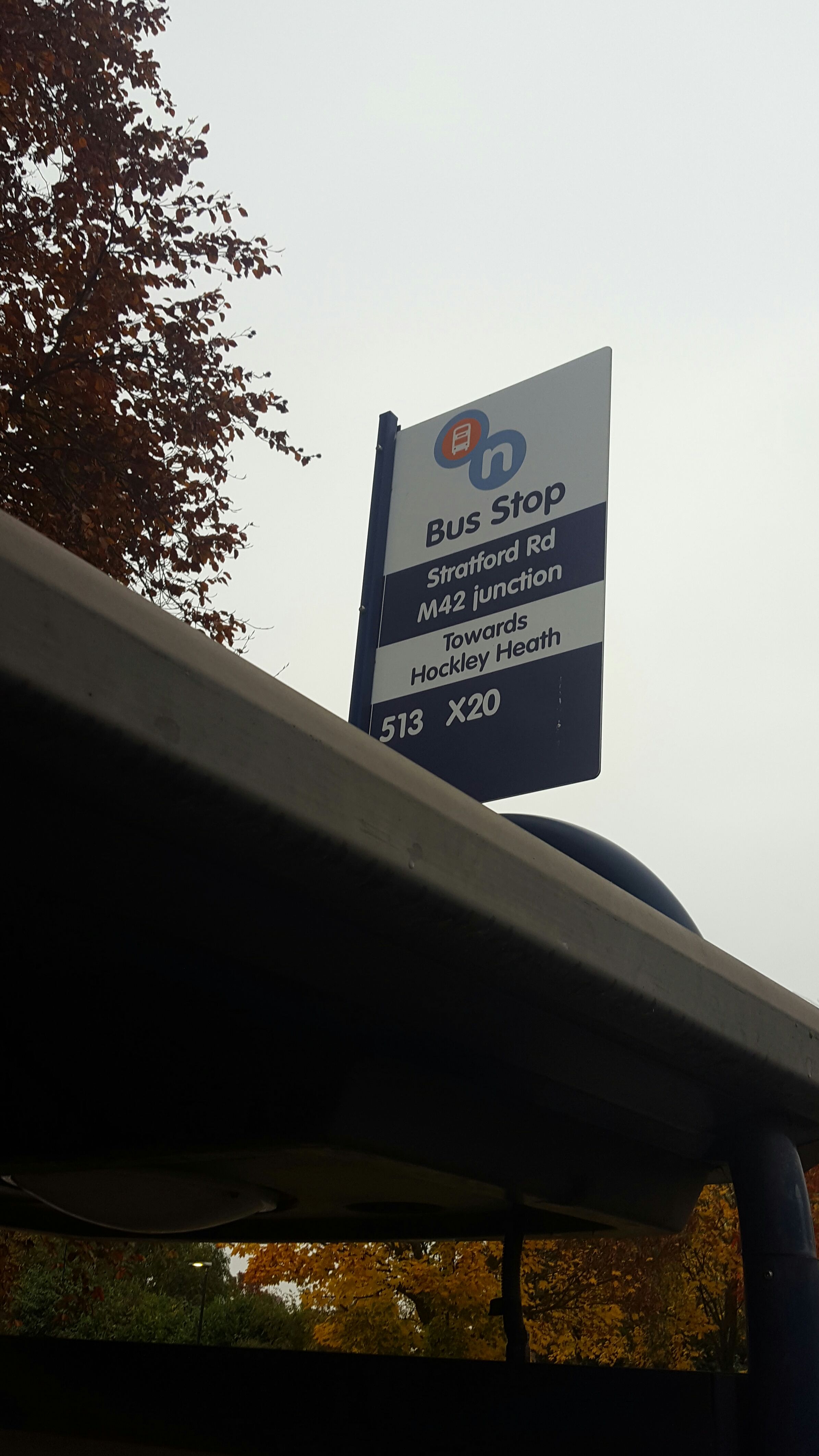 Taken by Francisco C.
See Notcutts stop, Blythe, on the map
Public transport to Notcutts stop (ID: nwmadmdt) in Blythe
Looking for directions to Notcutts in Blythe, United Kingdom?
Download the Moovit App to find the current schedule and step-by-step directions for Bus or Train routes that pass through Notcutts.
Looking for the nearest stops closest to Notcutts ? Check out this list of closest stops to your destination: Notcutts; Hawbridge Close; The Plough; Monkspath Hall Rd; Shirley; Solihull.
Bus: 5, X20, A7, A8, 519, 519.Train: WEST MIDLANDS RAILWAY, CHILTERN RAILWAYS.
We make riding on public transit to Notcutts easy, which is why over 1.5 million users, including users in Blythe trust Moovit as the best app for public transit.
Use the app to navigate to popular places including to the airport, hospital, stadium, grocery store, mall, coffee shop, school, college, and university.
Notcutts stop’s code is nwmadmdt
The first line to this stop is A8, at 07:30, and the last line is A8 at 21:16.
This stop serves Stagecoach Midlands and LandFlight’s lines
- Notcutts,
- Hawbridge Close,
- The Plough,
- Monkspath Hall Rd
Bus stops near Notcutts stop
- War Lane,
- Vicarage Street,
- Spread Eagle Ph,
- Union Rd,
- Amazon Warehouse,
- Peterbrook Road,
- Rail Station Bridge,
- Stourbridge Town,
- Boundary Drive,
- Upper Church Lane,
- Deans Rd,
- Queen Elizabeth Hospital,
- Jaguar Land Rover,
- Feldon Lane,
- Myton School,
- Long Lartin Prison,
- Sainsburys,
- Claverdon,
- Chester Rd,
- Paget High School
Popular public transport stations in Blythe
Get around Blythe by public transport!
Travelling around Blythe has never been so easy. See step by step directions as you travel to any attraction, street or major public transport station. View bus and train timetables, arrival times, service alerts and detailed routes on a map, so you know exactly how to get to anywhere in Blythe.
When travelling to any destination around Blythe use Moovit's Live Directions with Get Off Notifications to know exactly where and how far to walk, how long to wait for your line , and how many stops are left. Moovit will alert you when it’s time to get off — no need to constantly re-check whether yours is the next stop.
Wondering how to use public transport in Blythe or how to pay for public transport in Blythe? Moovit public transport app can help you navigate your way with public transport easily, and at minimum cost. It includes public transport fees, ticket prices, and costs. Looking for a map of Blythe public transport lines? Moovit public transport app shows all public transport maps in Blythe with all Bus, Train and Light rail routes and stops on an interactive map.
West Midlands has 3 transport type(s), including: Bus, Train and Light rail, operated by several transport agencies, including National Express West Midlands, National Express Coventry, National Express, Diamond Bus, Arriva Midlands, Stagecoach Midlands, West Midlands Metro, Stagecoach West, Stagecoach South Wales, First Potteries, First Worcestershire, LandFlight, trentbarton, D & G Bus and Flexibus