Nutter Lane stop - Monday schedule
| Line | Direction | Time |
|---|---|---|
| 283 | Dbs Temp Stop 3 | 06:23 |
| 283 | Dbs Temp Stop 3 | 07:10 |
| 283 | Dbs Temp Stop 3 | 07:40 |
| 283 | Dbs Temp Stop 3 | 08:10 |
| 283 | Dbs Temp Stop 3 | 08:40 |
| 283 | Dbs Temp Stop 3 | 09:11 |
| 283 | Dbs Temp Stop 3 | 09:41 |
| 283 | Dbs Temp Stop 3 | 10:11 |
| 283 | Dbs Temp Stop 3 | 10:41 |
| 283 | Dbs Temp Stop 3 | 11:11 |
| 283 | Dbs Temp Stop 3 | 11:41 |
| 283 | Dbs Temp Stop 3 | 12:11 |
| 283 | Dbs Temp Stop 3 | 12:41 |
| 283 | Dbs Temp Stop 3 | 13:12 |
| 283 | Dbs Temp Stop 3 | 13:42 |
| 283 | Dbs Temp Stop 3 | 14:12 |
| 283 | Dbs Temp Stop 3 | 14:41 |
| 283 | Dbs Temp Stop 3 | 15:25 |
| 283 | Dbs Temp Stop 3 | 15:55 |
| 283 | Dbs Temp Stop 3 | 16:25 |
| 283 | Dbs Temp Stop 3 | 16:56 |
| 283 | Dbs Temp Stop 3 | 17:25 |
| 283 | Dbs Temp Stop 3 | 17:55 |
| 283 | Dbs Temp Stop 3 | 18:25 |
| 283A | Dbs Temp Stop 3 | 18:51 |
Directions to Nutter Lane stop (Heckmondwike) with public transport
The following transport lines have routes that pass near Nutter Lane
 Bus: 253, 283, 254, 255, 263.
How to get to Nutter Lane stop by bus?
Click on the bus route to see step by step directions with maps, line arrival times and updated time schedules.
Bus stops near Nutter Lane stop in Heckmondwike
- Pit Lane, 2 min walk,
- Monk Ings Avenue, 5 min walk,
Bus lines to Nutter Lane stop in Heckmondwike
- 253, Greenside T1,
- 254, Bus Station,
- 255, Bus Stn,
- 263, Stand 17 Dewsbury Bus Station,
- 283, Heckmondwike - Bradford,
- 283A, Bradford - Heckmondwike,
What are the nearest stations to Nutter Lane?
The nearest stations to Nutter Lane are:
- Pit Lane stop is 104 meters away, 2 min walk.
- Monk Ings Avenue stop is 312 meters away, 5 min walk.
Which bus lines stop near Nutter Lane?
These bus lines stop near Nutter Lane: 253, 283.
What’s the nearest bus station to Nutter Lane in Heckmondwike?
The nearest bus station to Nutter Lane in Heckmondwike is Pit Lane. It’s a 2 min walk away.
What time is the first bus to Nutter Lane in Heckmondwike?
The 254 is the first bus that goes to Nutter Lane in Heckmondwike. It stops nearby at 04:49.
What time is the last bus to Nutter Lane in Heckmondwike?
The 254 is the last bus that goes to Nutter Lane in Heckmondwike. It stops nearby at 23:30.
Nutter Lane station
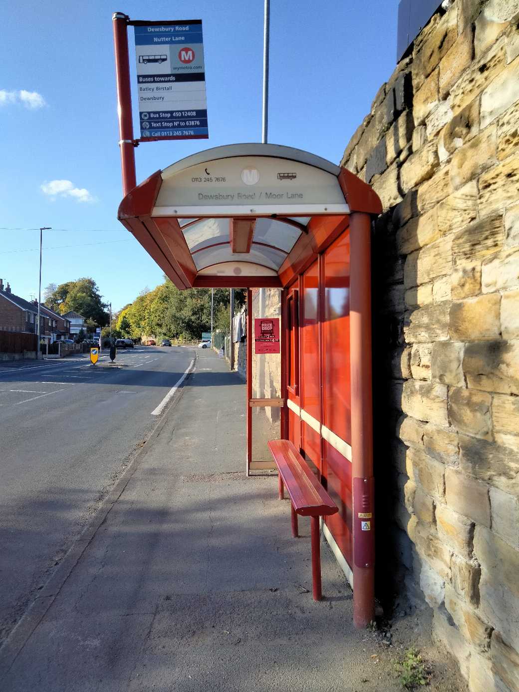 Taken by Anonymous
See Nutter Lane stop, Heckmondwike, on the map
Public transport to Nutter Lane stop (ID: 45012408) in Heckmondwike
Looking for directions to Nutter Lane in Heckmondwike, United Kingdom?
Download the Moovit App to find the current schedule and step-by-step directions for Bus routes that pass through Nutter Lane.
Looking for the nearest stops closest to Nutter Lane ? Check out this list of closest stops to your destination: Pit Lane; Monk Ings Avenue.
Bus: 253, 283, 254, 255, 263, 283A.
We make riding on public transit to Nutter Lane easy, which is why over 1.7 billion users, including users in Heckmondwike trust Moovit as the best app for public transit.
Use the app to navigate to popular places including to the airport, hospital, stadium, grocery store, mall, coffee shop, school, college, and university.
Nutter Lane stop’s code is 45012408
The first line to this stop is 283, at 06:23, and the last line is 283A at 22:51.
Selene Close, England, United Kingdom
This stop serves Arriva Yorkshire’s lines
- Pit Lane,
- Monk Ings Avenue
Bus stops near Nutter Lane stop
- King Lane,
- Hessle Barrow Lane,
- St. Helena Caravan Park,
- Red Hall Lane,
- Cultural B,
- Rookwood Avenue,
- St John's School,
- Arundel Gate/Charles Street Cs3,
- Calderdale Royal - Women & Childrens Unit,
- Northgate,
- Highgreave/High Greave Avenue,
- Barber Wood Road/Thundercliffe Road,
- Castleford College,
- Cottingley Drive Cottingley Fold,
- Sheffield,
- Meadowhall Road/Meadowhall Way,
- Wesley Road,
- Moor Lane Car Park,
- Howard Street/Doncaster Gate,
- Waterthorpe Greenway/Peaks Mount
Popular public transport stations in Heckmondwike
Get around Heckmondwike by public transport!
Travelling around Heckmondwike has never been so easy. See step by step directions as you travel to any attraction, street or major public transport station. View bus and train timetables, arrival times, service alerts and detailed routes on a map, so you know exactly how to get to anywhere in Heckmondwike.
When travelling to any destination around Heckmondwike use Moovit's Live Directions with Get Off Notifications to know exactly where and how far to walk, how long to wait for your line , and how many stops are left. Moovit will alert you when it’s time to get off — no need to constantly re-check whether yours is the next stop.
Wondering how to use public transport in Heckmondwike or how to pay for public transport in Heckmondwike? Moovit public transport app can help you navigate your way with public transport easily, and at minimum cost. It includes public transport fees, ticket prices, and costs. Looking for a map of Heckmondwike public transport lines? Moovit public transport app shows all public transport maps in Heckmondwike with all Bus, Train and Light rail routes and stops on an interactive map.
Yorkshire has 3 transport type(s), including: Bus, Train and Light rail, operated by several transport agencies, including First Leeds, First South Yorkshire, First York, Arriva Yorkshire, Stagecoach Yorkshire, National Rail, First Bradford, First Halifax, Calder Valley & Huddersfield, East Yorkshire, The Keighley Bus Company, South Yorkshire Future Tram, The Harrogate Bus Company, TM Travel, Coastliner and Stevenson's Travel