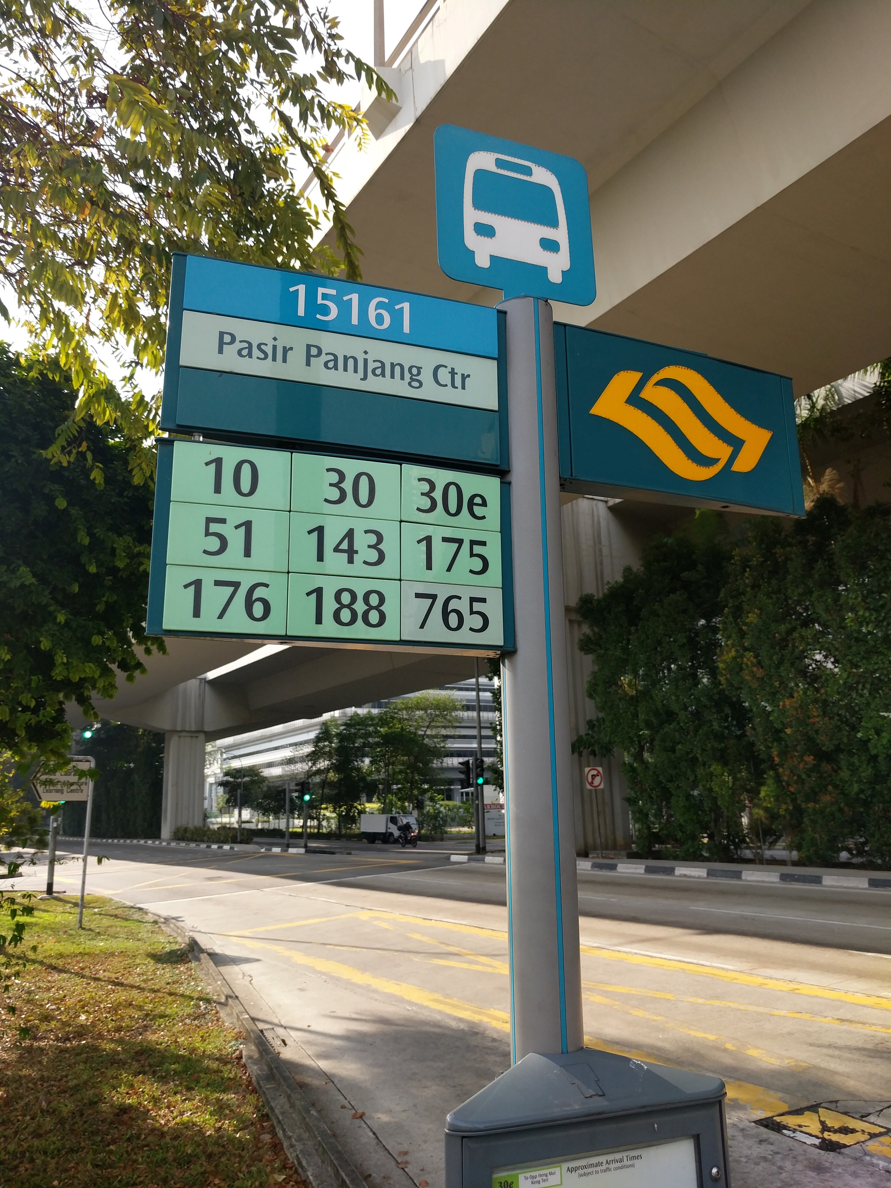
Pasir Panjang Rd - Opp Harbourside Bldg 2 (15161) stop - Thursday schedule
| Line | Direction | Time |
|---|---|---|
| 30 | Boon Lay Int | 05:40 |
| 30 | Boon Lay Int | 05:49 |
| 176 | Bt Panjang Int | 05:57 |
| 176 | Bt Panjang Int | 06:06 |
| 30 | Boon Lay Int | 06:08 |
| 188 | Choa Chu Kang Int | 06:10 |
| 176 | Bt Panjang Int | 06:16 |
| 143 | Jurong East Int | 06:19 |
| 30 | Boon Lay Int | 06:20 |
| 188 | Choa Chu Kang Int | 06:22 |
| 176 | Bt Panjang Int | 06:25 |
| 143 | Jurong East Int | 06:30 |
| 10 | Kent Ridge Ter | 06:31 |
| 30 | Boon Lay Int | 06:32 |
| 188 | Choa Chu Kang Int | 06:35 |
| 176 | Bt Panjang Int | 06:35 |
| 51 | Jurong East Int | 06:38 |
| 10 | Kent Ridge Ter | 06:40 |
| 143 | Jurong East Int | 06:41 |
| 30 | Boon Lay Int | 06:44 |
| 176 | Bt Panjang Int | 06:44 |
| 188 | Choa Chu Kang Int | 06:47 |
| 51 | Jurong East Int | 06:49 |
| 10 | Kent Ridge Ter | 06:49 |
| 143 | Jurong East Int | 06:52 |
Directions to Pasir Panjang Rd - Opp Harbourside Bldg 2 (15161) stop (Southwest) with public transport
The following transport lines have routes that pass near Pasir Panjang Rd - Opp Harbourside Bldg 2 (15161)
How to get to Pasir Panjang Rd - Opp Harbourside Bldg 2 (15161) stop by bus?
Click on the bus route to see step by step directions with maps, line arrival times and updated time schedules.
How to get to Pasir Panjang Rd - Opp Harbourside Bldg 2 (15161) stop by metro?
Click on the metro route to see step by step directions with maps, line arrival times and updated time schedules.
Bus stops near Pasir Panjang Rd - Opp Harbourside Bldg 2 (15161) stop in Southwest
- Pasir Panjang Rd - Harbourside Bldg 2 (15169), 2 min walk,
- Pasir Panjang Rd - Mapletree Business City (15159), 3 min walk,
- Pasir Panjang Rd - Labrador Pk Stn (15141), 7 min walk,
- Atp B Loading Bay, 8 min walk,
- Alexandra Rd - Alexandra Retail Ctr (15041), 9 min walk,
- Alexandra Rd - Opp Alexandra Retail Ctr (15049), 10 min walk,
Metro stations near Pasir Panjang Rd - Opp Harbourside Bldg 2 (15161) station in Southwest
- Pasir Panjang (CC26), 8 min walk,
- Queenstown (EW19), 42 min walk,
Bus lines to Pasir Panjang Rd - Opp Harbourside Bldg 2 (15161) stop in Southwest
- 10, Tampines Int ↔ Kent Ridge Ter,
- 30, Bedok Int ↔ Boon Lay Int,
- 51, Hougang Ctrl Int ↔ Jurong East Int,
- 143, Toa Payoh Int ↔ Jurong East Int,
- 175, Clementi Int ↔ Lor 1 Geylang Ter,
- 176, Bt Panjang Int ↔ Bt Merah Int,
- 188, Choa Chu Kang Int ↔ HarbourFront Int,
- CM 1, Choa Chu Kang Cres (Blk 681) → Alexandra Rd (Geneco),
- 30E, [AM Peak]: Pasir Panjang Rd (Opp Heng Mui Keng Terrace) [PM Peak]: Bedok Int,
- 188E, Choa Chu Kang Int → HarbourFront Int,
- PARK HOTEL ALEXANDRA SHUTTLE, Park Hotel Alexandra (Via One-North),
- TM 3, Jln Bt Merah (Blk 119),
- YM 1, Pasir Panjang Rd (Mapletree Business City),
- 573, Pasir Panjang Rd (Befpsa Bldg),
- ATP SHUTTLE, [PM] Queenstown MRT,
- 57, Bishan Int ↔ Bt Merah Int,
- 61, Bt Batok Int ↔ Eunos Int,
- 93, HarbourFront Int ↔ Eunos Int,
- 97, Jurong East Int ↔ Marina Ctr Ter,
- 100, Serangoon Int ↔ Ghim Moh Ter,
What are the nearest stations to Pasir Panjang Rd - Opp Harbourside Bldg 2 (15161)?
The nearest stations to Pasir Panjang Rd - Opp Harbourside Bldg 2 (15161) are:
- Pasir Panjang Rd - Harbourside Bldg 2 (15169) is 120 meters away, 2 min walk.
- Pasir Panjang Rd - Mapletree Business City (15159) is 204 meters away, 3 min walk.
- Pasir Panjang Rd - Labrador Pk Stn (15141) is 489 meters away, 7 min walk.
- Atp B Loading Bay is 562 meters away, 8 min walk.
- Pasir Panjang (CC26) is 589 meters away, 8 min walk.
- Alexandra Rd - Alexandra Retail Ctr (15041) is 676 meters away, 9 min walk.
- Alexandra Rd - Opp Alexandra Retail Ctr (15049) is 749 meters away, 10 min walk.
- Queenstown (EW19) is 3251 meters away, 42 min walk.
Which bus lines stop near Pasir Panjang Rd - Opp Harbourside Bldg 2 (15161)?
These bus lines stop near Pasir Panjang Rd - Opp Harbourside Bldg 2 (15161): 10, 176, 30, 51.
Which metro line stops near Pasir Panjang Rd - Opp Harbourside Bldg 2 (15161)?
CIRCLE LINE (to ⑨ Harbourfront)
What’s the nearest metro station to Pasir Panjang Rd - Opp Harbourside Bldg 2 (15161) in Southwest?
The nearest metro station to Pasir Panjang Rd - Opp Harbourside Bldg 2 (15161) in Southwest is Pasir Panjang (CC26). It’s a 8 min walk away.
What’s the nearest bus station to Pasir Panjang Rd - Opp Harbourside Bldg 2 (15161) in Southwest?
The nearest bus station to Pasir Panjang Rd - Opp Harbourside Bldg 2 (15161) in Southwest is Pasir Panjang Rd - Harbourside Bldg 2 (15169). It’s a 2 min walk away.
What time is the first metro to Pasir Panjang Rd - Opp Harbourside Bldg 2 (15161) in Southwest?
The CIRCLE LINE is the first metro that goes to Pasir Panjang Rd - Opp Harbourside Bldg 2 (15161) in Southwest. It stops nearby at 05:55.
What time is the last metro to Pasir Panjang Rd - Opp Harbourside Bldg 2 (15161) in Southwest?
The EAST WEST LINE is the last metro that goes to Pasir Panjang Rd - Opp Harbourside Bldg 2 (15161) in Southwest. It stops nearby at 00:14.
What time is the first bus to Pasir Panjang Rd - Opp Harbourside Bldg 2 (15161) in Southwest?
The 143 is the first bus that goes to Pasir Panjang Rd - Opp Harbourside Bldg 2 (15161) in Southwest. It stops nearby at 05:31.
What time is the last bus to Pasir Panjang Rd - Opp Harbourside Bldg 2 (15161) in Southwest?
The 30 is the last bus that goes to Pasir Panjang Rd - Opp Harbourside Bldg 2 (15161) in Southwest. It stops nearby at 01:07.
Pasir Panjang Rd - Opp Harbourside Bldg 2 (15161) station
 Taken by Amila S.
See Pasir Panjang Rd - Opp Harbourside Bldg 2 (15161) stop, Southwest, on the map
Public transport to Pasir Panjang Rd - Opp Harbourside Bldg 2 (15161) stop (ID: 15161) in Southwest
Looking for directions to Pasir Panjang Rd - Opp Harbourside Bldg 2 (15161) in Southwest, Singapore?
Download the Moovit App to find the current schedule and step-by-step directions for Bus or Metro routes that pass through Pasir Panjang Rd - Opp Harbourside Bldg 2 (15161).
Looking for the nearest stops closest to Pasir Panjang Rd - Opp Harbourside Bldg 2 (15161) ? Check out this list of closest stops to your destination: Pasir Panjang Rd - Harbourside Bldg 2 (15169); Pasir Panjang Rd - Mapletree Business City (15159); Pasir Panjang Rd - Labrador Pk Stn (15141); Atp B Loading Bay; Pasir Panjang (CC26); Alexandra Rd - Alexandra Retail Ctr (15041); Alexandra Rd - Opp Alexandra Retail Ctr (15049); Queenstown (EW19).
Bus: 10, 176, 30, 51, 143, 175, PARK HOTEL ALEXANDRA SHUTTLE, TM 3, YM 1, 573, ATP SHUTTLE.Metro: CIRCLE LINE, EAST WEST LINE.
We make riding on public transit to Pasir Panjang Rd - Opp Harbourside Bldg 2 (15161) easy, which is why over 1.5 million users, including users in Southwest trust Moovit as the best app for public transit.
Use the app to navigate to popular places including to the airport, hospital, stadium, grocery store, mall, coffee shop, school, college, and university.
Pasir Panjang Rd - Opp Harbourside Bldg 2 (15161) stop’s code is 15161
The first line to this stop is 30, at 05:40, and the last line is 51 at 00:47.
This stop serves SMRT, SBS Transit and Tower Transit’s lines
Bus stops near Pasir Panjang Rd - Opp Harbourside Bldg 2 (15161) stop
Metro stations near Pasir Panjang Rd - Opp Harbourside Bldg 2 (15161) station
Popular public transport stations in Southwest
Get around Southwest by public transport!
Travelling around Southwest has never been so easy. See step by step directions as you travel to any attraction, street or major public transport station. View bus and train timetables, arrival times, service alerts and detailed routes on a map, so you know exactly how to get to anywhere in Southwest.
When travelling to any destination around Southwest use Moovit's Live Directions with Get Off Notifications to know exactly where and how far to walk, how long to wait for your line , and how many stops are left. Moovit will alert you when it’s time to get off — no need to constantly re-check whether yours is the next stop.
Wondering how to use public transport in Southwest or how to pay for public transport in Southwest? Moovit public transport app can help you navigate your way with public transport easily, and at minimum cost. It includes public transport fees, ticket prices, and costs. Looking for a map of Southwest public transport lines? Moovit public transport app shows all public transport maps in Southwest with all Bus, Train, Metro, MRT & LRT, Ferry and Cable Car routes and stops on an interactive map.
Singapore has 6 transport type(s), including: Bus, Train, Metro, MRT & LRT, Ferry and Cable Car, operated by several transport agencies, including SMRT, SBS Transit, Tower Transit, Go-Ahead Singapore, Premium Bus, City Direct Bus, Changi Airport, Sentosa Development Corporation, Cross Border Bus, Singapore Cable Car Network, NUS Shuttle (ComfortDelGro), NTU Shuttle (ComfortDelGro), JTC Corp, Shuttle Bus (Appx. Schedule) and Tourist Bus (Book in Advance)