Directions to Penybontfawr (Powys) with public transport
The following transport lines have routes that pass near Penybontfawr
 Bus: 79A.
How to get to Penybontfawr by bus?
Click on the bus route to see step by step directions with maps, line arrival times and updated time schedules.
Bus stop near Penybontfawr in Powys
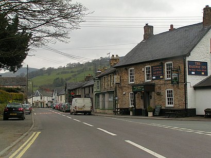
- Railway Inn, Penybontfawr, 6 min walk,
Bus lines to Penybontfawr in Powys
- 79A, Llangynog,
What are the nearest stations to Penybontfawr?
The nearest stations to Penybontfawr are:
- Railway Inn, Penybontfawr is 445 meters away, 6 min walk.
Which bus line stops near Penybontfawr?
79A (Llangynog)
What’s the nearest bus station to Penybontfawr in Powys?
The nearest bus station to Penybontfawr in Powys is Railway Inn, Penybontfawr. It’s a 6 min walk away.
What time is the first bus to Penybontfawr in Powys?
The 79A is the first bus that goes to Penybontfawr in Powys. It stops nearby at 08:07.
What time is the last bus to Penybontfawr in Powys?
The 79A is the last bus that goes to Penybontfawr in Powys. It stops nearby at 14:35.
See Penybontfawr, Powys, on the map
Public Transit to Penybontfawr in Powys
Wondering how to get to Penybontfawr in Powys? Moovit helps you find the best way to get to Penybontfawr with step-by-step directions from the nearest public transit station.
Moovit provides free maps and live directions to help you navigate through your city. View schedules, routes, timetables, and find out how long does it take to get to Penybontfawr in real time.
Looking for the nearest stop or station to Penybontfawr? Check out this list of stops closest to your destination: Railway Inn.
Bus: 79A.
Want to see if there’s another route that gets you there at an earlier time? Moovit helps you find alternative routes or times. Get directions from and directions to Penybontfawr easily from the Moovit App or Website.
We make riding to Penybontfawr easy, which is why over 1.5 million users, including users in Powys, trust Moovit as the best app for public transit. You don’t need to download an individual bus app or train app, Moovit is your all-in-one transit app that helps you find the best bus time or train time available.
For information on prices of bus, costs and ride fares to Penybontfawr, please check the Moovit app.
Use the app to navigate to popular places including to the airport, hospital, stadium, grocery store, mall, coffee shop, school, college, and university.
Penybontfawr Address: Station Road street in Powys
- Penybontfawr Sub Post Office,
- Ty Rhyd,
- Llanrhaeadr-ym-Mochnant,
- Castell Courtyard,
- Wild Welsh Meat,
- Revolution Bike Park,
- Tanat Supplies Ltd,
- Llangynog,
- Tanat Valley Coaches,
- S and L Wilkinson T/A,
- Michael Mihang,
- Llanfyllin,
- NH Carpentry and Property Renovations,
- The Lower Cross Keys,
- Llanfyllin High School,
- Llanfechain,
- Llanarmon D.C. Hall,
- Llanarmon Dyffryn-Ceiriog,
- Parking Lot,
- Llanfechain
Places Near Penybontfawr (Powys)
- Royal Gwent Hospital, Newport,
- UHW Short Stay Surgical Unit, Cardiff,
- IKEA, Cardiff,
- X10 Cardiff - Swansea Express Bus, Cardiff,
- Wrexham Maelor Hospital X-Ray Department, Wrexham,
- McArthurGlen Designer Outlet Bridgend, Bridgend,
- The Aber Falls, Gwynedd,
- Llandough Hospital, The Vale Of Glamorgan,
- Principality Stadium, Cardiff,
- Blackweir, Cardiff,
- Entrance C, Denbighshire,
- B Block, Newport,
- Trecco Bay Holiday Park, Bridgend,
- RGH X-Ray Department, Rhondda Cynon Taf,
- Llanberis Raf Reserve Depot (Bomb Store), Gwynedd,
- Entrance B - Staff Only, Wrexham,
- Imaging Unit, Denbighshire,
- Belle Vue Clinic, Newport,
- Wrexham Maelor Hospital Eye Out Patients, Wrexham,
- Thornhill Cemetery Crematorium, Cardiff
How to get to popular places in Wales with public transport
Get around Powys by public transport!
Travelling around Powys has never been so easy. See step by step directions as you travel to any attraction, street or major public transport station. View bus and train timetables, arrival times, service alerts and detailed routes on a map, so you know exactly how to get to anywhere in Powys.
When travelling to any destination around Powys use Moovit's Live Directions with Get Off Notifications to know exactly where and how far to walk, how long to wait for your line , and how many stops are left. Moovit will alert you when it’s time to get off — no need to constantly re-check whether yours is the next stop.
Wondering how to use public transport in Powys or how to pay for public transport in Powys? Moovit public transport app can help you navigate your way with public transport easily, and at minimum cost. It includes public transport fees, ticket prices, and costs. Looking for a map of Powys public transport lines? Moovit public transport app shows all public transport maps in Powys with all Bus and Train routes and stops on an interactive map.
Wales has 2 transport type(s), including: Bus and Train, operated by several transport agencies, including National Rail, O.R.Jones, M & H Coaches, Peyton Travel, Gwynfor Coaches, Nefyn, Edwards Coaches, Cardiff Bus, Pembrokeshire County Council, Crickhowell Taxis, Village & Valleys Travel, South Wales Transport, Forge Travel, Sarah Bell and Phil Anslow Travel