Rawlins Croft stop - Wednesday schedule
| Line | Direction | Time |
|---|---|---|
| 67 | Dale End | 04:23 |
| 67 | Dale End | 05:03 |
| 67 | Dale End | 05:23 |
| X64 | Amazon Warehouse | 05:34 |
| 67 | Dale End | 05:42 |
| 67 | Dale End | 05:56 |
| 67 | Dale End | 06:19 |
| 67 | Dale End | 06:34 |
| 67 | Dale End | 06:50 |
| X64 | Amazon Warehouse | 07:01 |
| 67 | Dale End | 07:04 |
| 67 | Dale End | 07:17 |
| X64 | Amazon Warehouse | 07:31 |
| 67 | Dale End | 07:32 |
| 67 | Dale End | 07:47 |
| 67 | Dale End | 08:01 |
| 67 | Dale End | 08:16 |
| 67 | Dale End | 08:32 |
| 67 | Dale End | 08:47 |
| 67 | Dale End | 09:03 |
| 67 | Dale End | 09:19 |
| 64 | Amazon Warehouse | 09:25 |
| 67 | Dale End | 09:36 |
| 67 | Dale End | 09:51 |
| 67 | Dale End | 10:06 |
Directions to Rawlins Croft stop (Castle Vale) with public transport
The following transport lines have routes that pass near Rawlins Croft
 Bus: 64, 67, 71, X64, 71A.
- Train: CROSSCOUNTRY, WEST MIDLANDS RAILWAY.
How to get to Rawlins Croft stop by bus?
Click on the bus route to see step by step directions with maps, line arrival times and updated time schedules.
How to get to Rawlins Croft stop by train?
Click on the train route to see step by step directions with maps, line arrival times and updated time schedules.
Bus stops near Rawlins Croft stop in Castle Vale
- Rawlins Croft, 1 min walk,
- Squadron Close, 8 min walk,
- St Cuthberts Place, 9 min walk,
Train stations near Rawlins Croft station in Castle Vale
- Chester Road, 30 min walk,
Bus lines to Rawlins Croft stop in Castle Vale
- 64, Holborn Hill,
- X64, Dale End,
- 67, Dixon Close,
- 71, Chelmsley Interchange,
- 71A, Sutton Coldfield Lower P,
What are the nearest stations to Rawlins Croft?
The nearest stations to Rawlins Croft are:
- Rawlins Croft stop is 36 meters away, 1 min walk.
- Squadron Close stop is 563 meters away, 8 min walk.
- St Cuthberts Place stop is 632 meters away, 9 min walk.
- Chester Road station is 2324 meters away, 30 min walk.
Which bus lines stop near Rawlins Croft?
These bus lines stop near Rawlins Croft: 64, 67, 71.
Which train line stops near Rawlins Croft?
CROSSCOUNTRY (Birmingham New Street)
What’s the nearest train station to Rawlins Croft in Castle Vale?
The nearest train station to Rawlins Croft in Castle Vale is Chester Road. It’s a 30 min walk away.
What’s the nearest bus station to Rawlins Croft in Castle Vale?
The nearest bus station to Rawlins Croft in Castle Vale is Rawlins Croft. It’s a 1 min walk away.
What time is the first train to Rawlins Croft in Castle Vale?
The WEST MIDLANDS RAILWAY is the first train that goes to Rawlins Croft in Castle Vale. It stops nearby at 09:23.
What time is the last train to Rawlins Croft in Castle Vale?
The WEST MIDLANDS RAILWAY is the last train that goes to Rawlins Croft in Castle Vale. It stops nearby at 23:22.
What time is the first bus to Rawlins Croft in Castle Vale?
The 71A is the first bus that goes to Rawlins Croft in Castle Vale. It stops nearby at 04:38.
What time is the last bus to Rawlins Croft in Castle Vale?
The 67 is the last bus that goes to Rawlins Croft in Castle Vale. It stops nearby at 01:33.
Rawlins Croft station
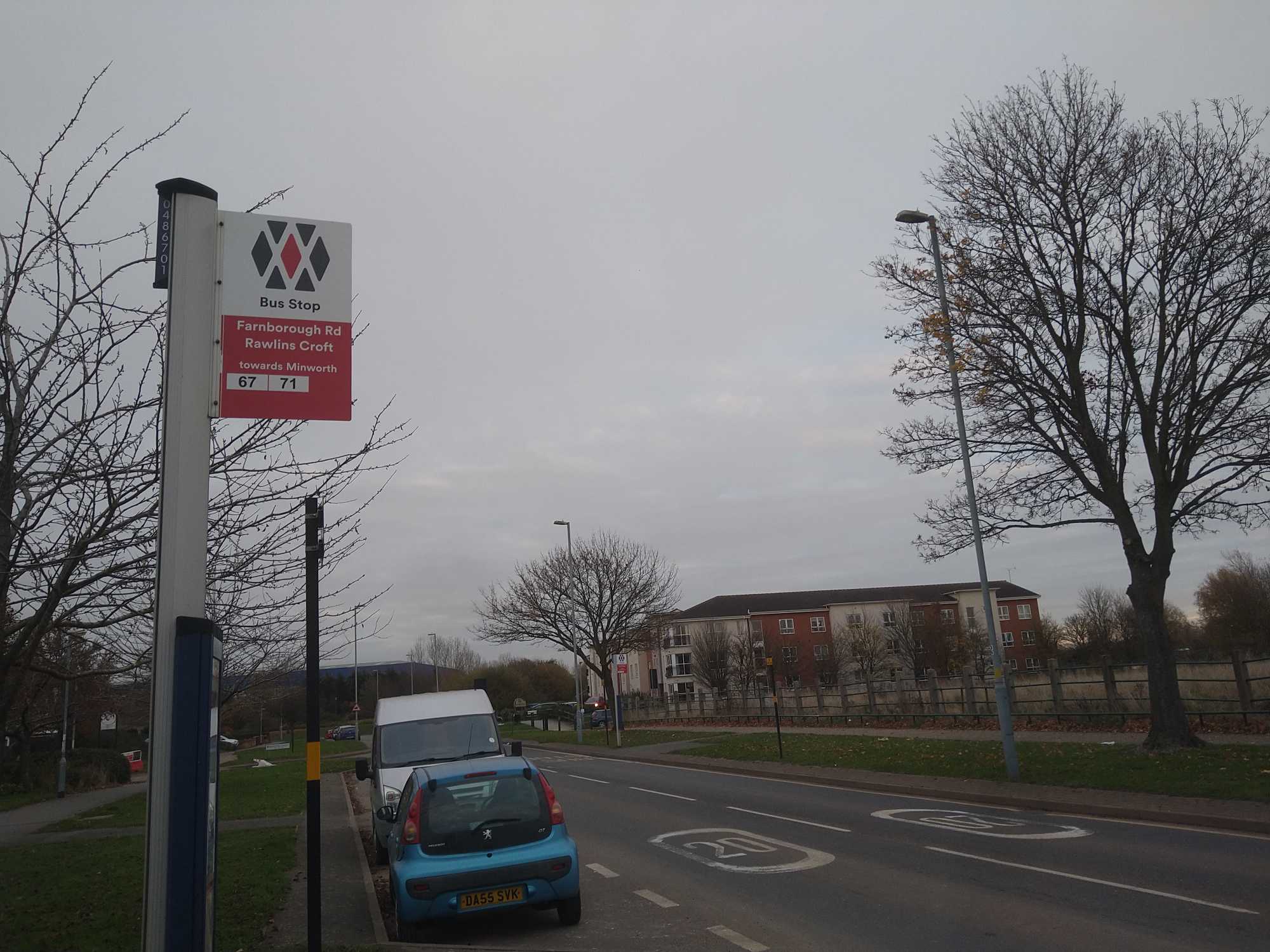 Taken by Rhapsody B.
See Rawlins Croft stop, Castle Vale, on the map
Public transport to Rawlins Croft stop (ID: nwmgpajm) in Castle Vale
Looking for directions to Rawlins Croft in Castle Vale, United Kingdom?
Download the Moovit App to find the current schedule and step-by-step directions for Bus or Train routes that pass through Rawlins Croft.
Looking for the nearest stops closest to Rawlins Croft ? Check out this list of closest stops to your destination: Rawlins Croft; Squadron Close; St Cuthberts Place; Chester Road.
Bus: 64, 67, 71, X64, 71A.Train: CROSSCOUNTRY, WEST MIDLANDS RAILWAY.
We make riding on public transit to Rawlins Croft easy, which is why over 1.7 billion users, including users in Castle Vale trust Moovit as the best app for public transit.
Use the app to navigate to popular places including to the airport, hospital, stadium, grocery store, mall, coffee shop, school, college, and university.
Rawlins Croft stop’s code is nwmgpajm
The first line to this stop is 67, at 04:23, and the last line is 67 at 00:09.
School Close, Birmingham, England, United Kingdom
This stop serves National Express West Midlands’s lines
- Rawlins Croft,
- Squadron Close,
- St Cuthberts Place
Bus stops near Rawlins Croft stop
- Chester Road
Train station near Rawlins Croft station
- Vicarage Street,
- Corbett Hospital,
- Kentmere Tower,
- New Cross Hospital,
- Wythall,
- Clayhanger Village,
- Old Square,
- Amazon Warehouse,
- Albert Road,
- Widney Manor,
- Leopold Street,
- Wellesbourne Market,
- Fairfax School,
- Ryders Hayes,
- Perry Barr,
- Blackwell Road,
- Car Craft,
- Great Malvern Railway Station,
- Steelpark Road,
- Yardley Wood
Popular public transport stations in Castle Vale
Get around Castle Vale by public transport!
Travelling around Castle Vale has never been so easy. See step by step directions as you travel to any attraction, street or major public transport station. View bus and train timetables, arrival times, service alerts and detailed routes on a map, so you know exactly how to get to anywhere in Castle Vale.
When travelling to any destination around Castle Vale use Moovit's Live Directions with Get Off Notifications to know exactly where and how far to walk, how long to wait for your line , and how many stops are left. Moovit will alert you when it’s time to get off — no need to constantly re-check whether yours is the next stop.
Wondering how to use public transport in Castle Vale or how to pay for public transport in Castle Vale? Moovit public transport app can help you navigate your way with public transport easily, and at minimum cost. It includes public transport fees, ticket prices, and costs. Looking for a map of Castle Vale public transport lines? Moovit public transport app shows all public transport maps in Castle Vale with all Bus, Train and Light rail routes and stops on an interactive map.
West Midlands has 3 transport type(s), including: Bus, Train and Light rail, operated by several transport agencies, including National Express West Midlands, National Express Coventry, National Express, Diamond Bus, Arriva Midlands, Stagecoach Midlands, West Midlands Metro, Stagecoach West, Stagecoach South Wales, First Potteries, First Worcestershire, LandFlight, trentbarton, D & G Bus and Flexibus