Riddfield Road stop - Wednesday schedule
| Line | Direction | Time |
|---|---|---|
| X13 | Wincanton | 05:19 |
| X13 | Chelmsley Interchange | 05:24 |
| X12 | Solihull Station Interchange | 05:39 |
| X13 | Chelmsley Interchange | 05:54 |
| X12 | Solihull Station Interchange | 06:10 |
| X12 | Solihull Station Interchange | 06:36 |
| X13 | Chelmsley Interchange | 06:46 |
| X12 | Solihull Station Interchange | 06:56 |
| X13 | Chelmsley Interchange | 07:08 |
| X12 | Solihull Station Interchange | 07:23 |
| X13 | Chelmsley Interchange | 07:33 |
| X12 | Solihull Station Interchange | 07:43 |
| X12 | Birmingham International Station | 07:54 |
| X13 | Chelmsley Interchange | 08:04 |
| X12 | Solihull Station Interchange | 08:14 |
| X13 | Chelmsley Interchange | 08:24 |
| X12 | Solihull Station Interchange | 08:36 |
| X13 | Chelmsley Interchange | 08:49 |
| X12 | Solihull Station Interchange | 09:04 |
| 64 | Amazon Warehouse | 09:15 |
| X13 | Chelmsley Interchange | 09:19 |
| X12 | Solihull Station Interchange | 09:33 |
| X13 | Chelmsley Interchange | 09:48 |
| X12 | Solihull Station Interchange | 10:03 |
| 64 | Amazon Warehouse | 10:15 |
Directions to Riddfield Road stop (Bromford & Hodge Hill) with public transport
The following transport lines have routes that pass near Riddfield Road
 Bus: X12, X13, 25, 64, 28.
- Train: WEST MIDLANDS RAILWAY.
How to get to Riddfield Road stop by bus?
Click on the bus route to see step by step directions with maps, line arrival times and updated time schedules.
How to get to Riddfield Road stop by train?
Click on the train route to see step by step directions with maps, line arrival times and updated time schedules.
Bus stops near Riddfield Road stop in Bromford & Hodge Hill
- Riddfield Road, 1 min walk,
- Berrandale Gardens, 9 min walk,
- Dunlop Way, 26 min walk,
- Fort Dunlop, 30 min walk,
Train stations near Riddfield Road station in Bromford & Hodge Hill
- Gravelly Hill, 20 min walk,
Bus lines to Riddfield Road stop in Bromford & Hodge Hill
- X12, Chelmsley Interchange,
- X13, Sumner Road,
- 25, Six Ways,
- 64, Amazon Warehouse,
- 28, Perry Barr - Birmingham,
- 71, Sutton Coldfield - Chelmsley Wood,
- 71, Chelmsley Wood - Sutton Coldfield,
- 71A, Pype Hayes - Chelmsley Wood,
- 96, Chelmsley Wood - Kingstanding,
- X64, Dale End,
- FD, Fort Dunlop,
What are the nearest stations to Riddfield Road?
The nearest stations to Riddfield Road are:
- Riddfield Road stop is 1 meters away, 1 min walk.
- Berrandale Gardens stop is 682 meters away, 9 min walk.
- Gravelly Hill station is 1543 meters away, 20 min walk.
- Dunlop Way stop is 2059 meters away, 26 min walk.
- Fort Dunlop stop is 2327 meters away, 30 min walk.
Which bus lines stop near Riddfield Road?
These bus lines stop near Riddfield Road: X12, X13.
Which train line stops near Riddfield Road?
WEST MIDLANDS RAILWAY (Northampton)
What’s the nearest train station to Riddfield Road in Bromford & Hodge Hill?
The nearest train station to Riddfield Road in Bromford & Hodge Hill is Gravelly Hill. It’s a 20 min walk away.
What’s the nearest bus station to Riddfield Road in Bromford & Hodge Hill?
The nearest bus station to Riddfield Road in Bromford & Hodge Hill is Riddfield Road. It’s a 1 min walk away.
What time is the first train to Riddfield Road in Bromford & Hodge Hill?
The WEST MIDLANDS RAILWAY is the first train that goes to Riddfield Road in Bromford & Hodge Hill. It stops nearby at 09:18.
What time is the last train to Riddfield Road in Bromford & Hodge Hill?
The WEST MIDLANDS RAILWAY is the last train that goes to Riddfield Road in Bromford & Hodge Hill. It stops nearby at 23:22.
What time is the first bus to Riddfield Road in Bromford & Hodge Hill?
The 96 is the first bus that goes to Riddfield Road in Bromford & Hodge Hill. It stops nearby at 03:02.
What time is the last bus to Riddfield Road in Bromford & Hodge Hill?
The 96 is the last bus that goes to Riddfield Road in Bromford & Hodge Hill. It stops nearby at 03:02.
Riddfield Road station
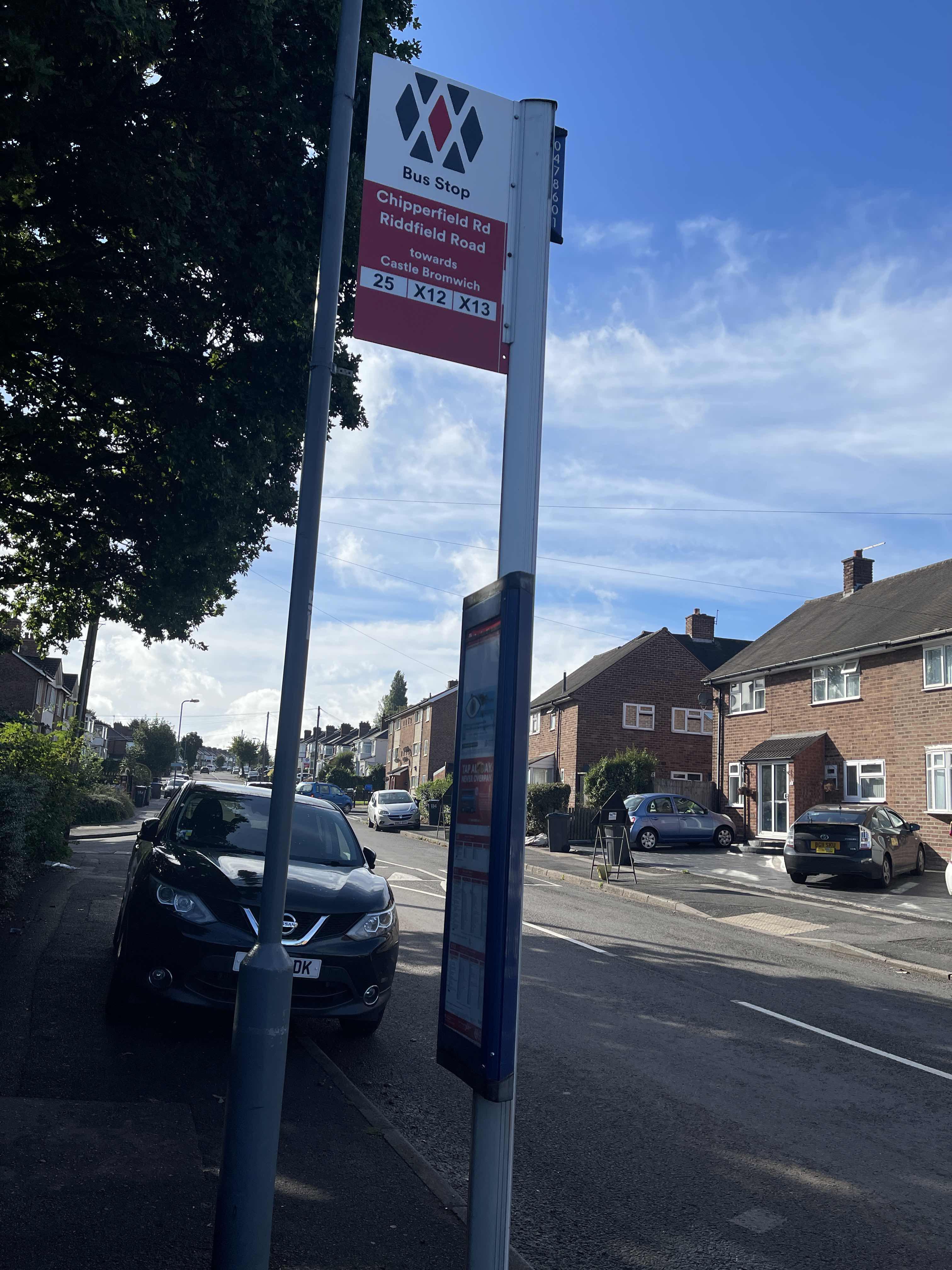 Taken by Nico L.
See Riddfield Road stop, Bromford & Hodge Hill, on the map
Public transport to Riddfield Road stop (ID: nwmgmwga) in Bromford & Hodge Hill
Looking for directions to Riddfield Road in Bromford & Hodge Hill, United Kingdom?
Download the Moovit App to find the current schedule and step-by-step directions for Bus or Train routes that pass through Riddfield Road.
Looking for the nearest stops closest to Riddfield Road ? Check out this list of closest stops to your destination: Riddfield Road; Berrandale Gardens; Gravelly Hill; Dunlop Way; Fort Dunlop.
Bus: X12, X13, 25, 64, 28, 71, 71, 71A, 96, X64, FD.Train: WEST MIDLANDS RAILWAY.
We make riding on public transit to Riddfield Road easy, which is why over 1.7 billion users, including users in Bromford & Hodge Hill trust Moovit as the best app for public transit.
Use the app to navigate to popular places including to the airport, hospital, stadium, grocery store, mall, coffee shop, school, college, and university.
Riddfield Road stop’s code is nwmgmwga
The first line to this stop is X13, at 05:19, and the last line is X12 at 23:35.
This stop serves National Express West Midlands and Solus Coaches’s lines
- Riddfield Road,
- Berrandale Gardens,
- Dunlop Way,
- Fort Dunlop
Bus stops near Riddfield Road stop
- Gravelly Hill
Train station near Riddfield Road station
- Bosty Lane,
- Woodthorpe Gardens,
- Jaguar Land Rover,
- Maypole Shops,
- University Station,
- Hoo Farm Industrial Estate,
- King Edward Road,
- M42 Junction 10,
- Tamworth,
- Green Lane Park,
- St James Road,
- Lapworth,
- Dark Lane,
- Amazon Warehouse,
- Waterson Croft,
- Newlands Close,
- Camp Hill Schools,
- Coleshill Parkway,
- Chaceley Close,
- Bilston Fc
Popular public transport stations in Bromford & Hodge Hill
Get around Bromford & Hodge Hill by public transport!
Travelling around Bromford & Hodge Hill has never been so easy. See step by step directions as you travel to any attraction, street or major public transport station. View bus and train timetables, arrival times, service alerts and detailed routes on a map, so you know exactly how to get to anywhere in Bromford & Hodge Hill.
When travelling to any destination around Bromford & Hodge Hill use Moovit's Live Directions with Get Off Notifications to know exactly where and how far to walk, how long to wait for your line , and how many stops are left. Moovit will alert you when it’s time to get off — no need to constantly re-check whether yours is the next stop.
Wondering how to use public transport in Bromford & Hodge Hill or how to pay for public transport in Bromford & Hodge Hill? Moovit public transport app can help you navigate your way with public transport easily, and at minimum cost. It includes public transport fees, ticket prices, and costs. Looking for a map of Bromford & Hodge Hill public transport lines? Moovit public transport app shows all public transport maps in Bromford & Hodge Hill with all Bus, Train and Light rail routes and stops on an interactive map.
West Midlands has 3 transport type(s), including: Bus, Train and Light rail, operated by several transport agencies, including National Express West Midlands, National Express Coventry, National Express, Diamond Bus, Arriva Midlands, Stagecoach Midlands, West Midlands Metro, Stagecoach West, Stagecoach South Wales, First Potteries, First Worcestershire, LandFlight, trentbarton, D & G Bus and Flexibus