Directions to St Devenick's (Aberdeen) with public transport
The following transport lines have routes that pass near St Devenick's
How to get to St Devenick's by bus?
Click on the bus route to see step by step directions with maps, line arrival times and updated time schedules.
Bus stations near St Devenick's in Aberdeen
- Baillieswells Road, Cults,1 min walk,
- Cairn Road, Cults,2 min walk,
Bus lines to St Devenick's in Aberdeen
- 19,Peterculter,
- 201,Aberdeen,
- 202,Torphins,
- 19S,Milltimber,
What are the nearest stations to St Devenick's?
The nearest stations to St Devenick's are:
- Baillieswells Road, Cults is 63 meters away, 1 min walk.
- Cairn Road, Cults is 146 meters away, 2 min walk.
Which bus lines stop near St Devenick's?
These bus lines stop near St Devenick's: 19, 202.
What’s the nearest bus stop to St Devenick's in Aberdeen?
The nearest bus stop to St Devenick's in Aberdeen is Baillieswells Road, Cults. It’s a 1 min walk away.
See St Devenick's, Aberdeen, on the map
Public Transit to St Devenick's in Aberdeen
Wondering how to get to St Devenick's in Aberdeen, United Kingdom? Moovit helps you find the best way to get to St Devenick's with step-by-step directions from the nearest public transit station.
Moovit provides free maps and live directions to help you navigate through your city. View schedules, routes, timetables, and find out how long does it take to get to St Devenick's in real time.
Looking for the nearest stop or station to St Devenick's? Check out this list of stops closest to your destination: Baillieswells Road; Cairn Road.
Bus:1920220119S
Want to see if there’s another route that gets you there at an earlier time? Moovit helps you find alternative routes or times. Get directions from and directions to St Devenick's easily from the Moovit App or Website.
We make riding to St Devenick's easy, which is why over 1.5 million users, including users in Aberdeen, trust Moovit as the best app for public transit. You don’t need to download an individual bus app or train app, Moovit is your all-in-one transit app that helps you find the best bus time or train time available.
For information on prices of bus and train, costs and ride fares to St Devenick's, please check the Moovit app.
Use the app to navigate to popular places including to the airport, hospital, stadium, grocery store, mall, coffee shop, school, college, and university.
St Devenick's Address: North Deeside Road street in Aberdeen
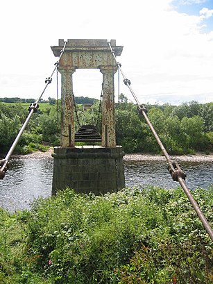
St. Devenick's Bridge (locally known as the Shakkin' Briggie, or as Morison's Bridge) is a suspension footbridge which crosses the River Dee from Ardoe to Cults near Aberdeen in Scotland.Wiki
Attractions near St Devenick's
Bieldside,The Bieldside,Bieldside Station Road, Cults,The Bieldside Inn,37 North Deeside Road,Kemtech Products Ltd.,Marchbank Road,Bieldside Post Office,Dunnottar Properties Ltd.,Morning Noon & Night Ltd.,Camphill Architects,Rago Ltd.,The Property Management Co. (Aberdeen) Ltd.,Deeside Golf Club,Camphill Rudolf Steiner Schools Ltd.,Camphill Medical Practice Ltd.,Canny Communications,Profile Model Agency,Waterwheel Inn Hotel,Camphill Village Trust Ltd.How to get to popular attractions in Aberdeen with public transportation
Glasgow Prestwick Airport (PIK), Prestwick,Bishopbriggs, Bishopbriggs,The Three Sisters, Edinburgh,Drumgelloch Railway Station (DRU), Airdrie,Paisley Gilmour Street Railway Station (PYG), Paisley,Giffnock, Giffnock,Kirkcaldy Bus Station, Kirkcaldy And Dysart,Cineworld,Ocean Terminal, Edinburgh,Hillhead Subway Station, Glasgow,Scottish National Gallery, Edinburgh,World's End, Edinburgh,Airlink Bus Stop | Edinburgh Airport, Ratho Station,Newton Mearns, Newton Mearns,McEwan Square, Edinburgh,Partick Railway Station (PTK), Glasgow,England / Scotland Border, Carlisle District (B),Union Square, Aberdeen,Soar at intu Braehead, Renfrew,Aberdeen International Airport (ABZ), DyceGet around Aberdeen by public transport!
Travelling around Aberdeen has never been so easy. See step by step directions as you travel to any attraction, street or major public transport station. View bus and train timetables, arrival times, service alerts and detailed routes on a map, so you know exactly how to get to anywhere in Aberdeen.
When travelling to any destination around Aberdeen use Moovit's Live Directions with Get Off Notifications to know exactly where and how far to walk, how long to wait for your line , and how many stops are left. Moovit will alert you when it’s time to get off — no need to constantly re-check whether yours is the next stop.
Wondering how to use public transport in Aberdeen or how to pay for public transport in Aberdeen? Moovit public transport app can help you navigate your way with public transport easily, and at minimum cost. It includes public transport fees, ticket prices, and costs. Looking for a map of Aberdeen public transport lines? Moovit public transport app shows all public transport maps in Aberdeen with all bus or train routes and stops on an interactive map.
Aberdeen has 2 transport type(s), including: bus or train, operated by several transport agencies, including First Greater Glasgow, First Aberdeen, Lothian Buses, McGill's Bus Service, Stagecoach East Scotland, Stagecoach Bluebird, Xplore Dundee, Community Transport Glasgow, Prentice Westwood, McCall's Coaches, J P Minibus, National Rail, R Robertson & Son, Burnbrae Garage and Ember