West Street stop - Tuesday schedule
| Line | Direction | Time |
|---|---|---|
| 48 | City Centre, the Centre | 03:18 |
| 43 | City Centre, Broad Quay | 03:43 |
| 49 | City Centre, the Centre | 03:47 |
| 48 | City Centre, the Centre | 04:16 |
| 43 | City Centre, Broad Quay | 04:44 |
| 49 | City Centre, the Centre | 04:46 |
| 41 | Avonmouth | 05:11 |
| 48 | City Centre, the Centre | 05:16 |
| 45 | City Centre, Broad Quay | 05:22 |
| 6 | City Centre, Broad Quay | 05:29 |
| 43 | City Centre, Broad Quay | 05:34 |
| 5 | Clifton Village | 05:43 |
| 44 | City Centre, Broad Quay | 05:43 |
| 49 | City Centre, the Centre | 05:44 |
| 7 | City Centre, Broad Quay | 05:51 |
| 24 | Ashton Vale | 05:56 |
| 45 | City Centre, Broad Quay | 05:59 |
| 43 | City Centre, Broad Quay | 06:06 |
| 41 | Avonmouth | 06:07 |
| 6 | City Centre, Broad Quay | 06:13 |
| 44 | City Centre, Broad Quay | 06:13 |
| 48 | City Centre, the Centre | 06:17 |
| 42 | City Centre, Broad Quay | 06:17 |
| 5 | Clifton Village | 06:23 |
| 43 | City Centre, Broad Quay | 06:29 |
Directions to West Street stop (Bristol) with public transport
The following transport lines have routes that pass near West Street
How to get to West Street stop by bus?
Click on the bus route to see step by step directions with maps, line arrival times and updated time schedules.
How to get to West Street stop by train?
Click on the train route to see step by step directions with maps, line arrival times and updated time schedules.
Bus stops near West Street stop in Bristol
- Cabot Circus South, 3 min walk,
- Temple Way, 6 min walk,
Bus lines to West Street stop in Bristol
- 5, Clifton Village,
- 6, Kingswood,
- 7, City Centre, Broad Quay,
- 8, Temple Meads Station,
- 16, City Centre, Rupert Street,
- 24, Ashton Vale,
- 41, Kingswood,
- 42, Cherry Gardens,
- 43, Cadbury Heath,
- 44, Cadbury Heath,
- 45, City Centre, Broad Quay,
- 46, Uwe Frenchay,
- 47, City Centre, the Centre,
- 48, Downend,
- 49, Staple Hill,
- 50, Frenchay,
- M2, Long Ashton Park & Ride,
- 9, Portway P&R,
- 47X, Oldbury Court,
- 48X, Emersons Green,
What are the nearest stations to West Street?
The nearest stations to West Street are:
- Cabot Circus South is 184 meters away, 3 min walk.
- Temple Way is 387 meters away, 6 min walk.
Which bus lines stop near West Street?
These bus lines stop near West Street: 2, 41, 42, 43, 49, 7, Y1.
Which train line stops near West Street?
GREAT WESTERN RAILWAY (Taunton)
What’s the nearest bus station to West Street in Bristol?
The nearest bus station to West Street in Bristol is Cabot Circus South. It’s a 3 min walk away.
What time is the first bus to West Street in Bristol?
The 43 is the first bus that goes to West Street in Bristol. It stops nearby at 03:01.
What time is the last bus to West Street in Bristol?
The 49 is the last bus that goes to West Street in Bristol. It stops nearby at 02:53.
What time is the first ferry to West Street in Bristol?
The BRISTOL FERRY BOATS is the first ferry that goes to West Street in Bristol. It stops nearby at 10:00.
What time is the last ferry to West Street in Bristol?
The BRISTOL FERRY BOATS is the last ferry that goes to West Street in Bristol. It stops nearby at 17:35.
West Street station
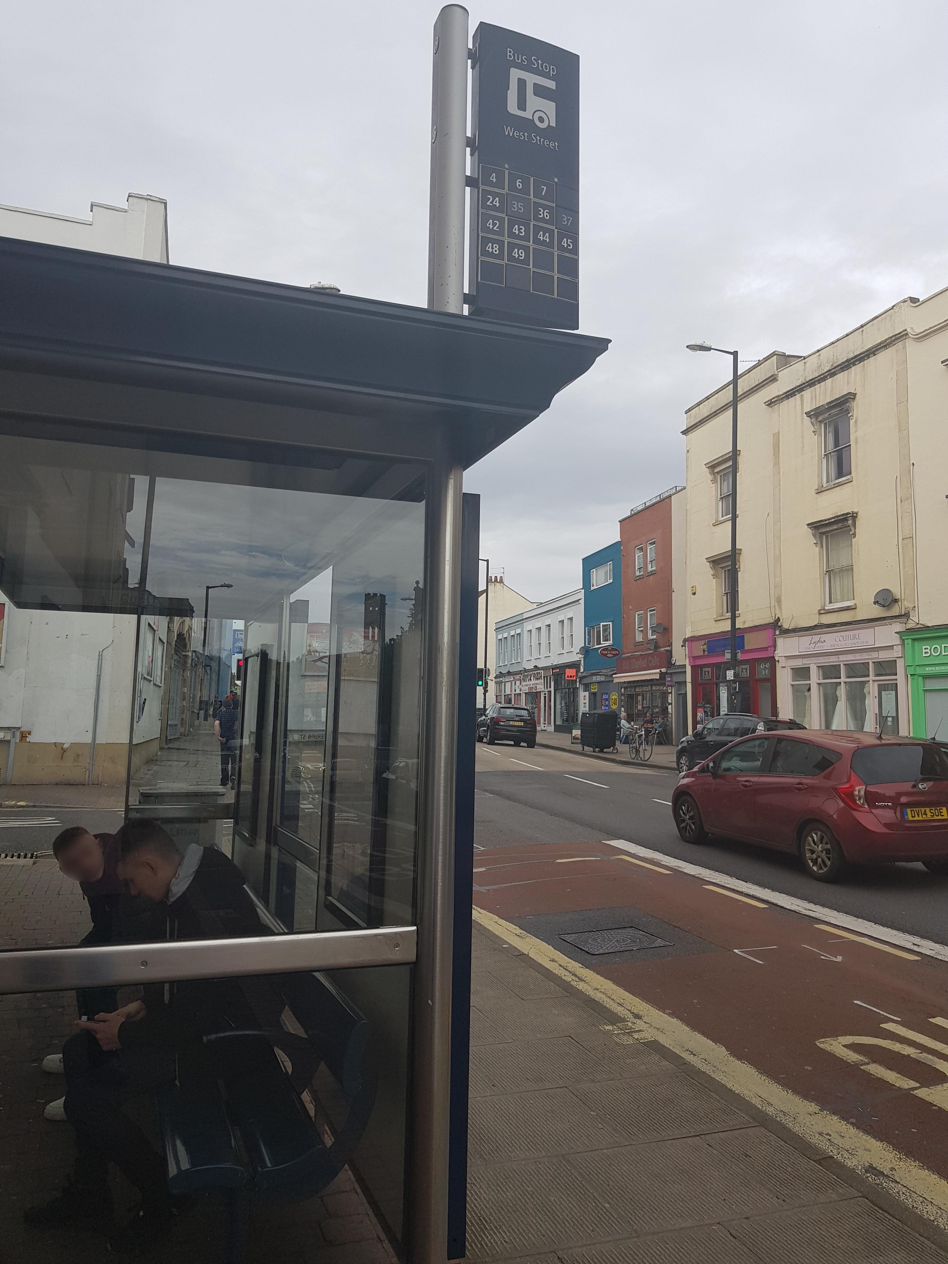 Taken by Anonymous
See West Street stop, Bristol, on the map
Public transport to West Street stop (ID: bstjdwj) in Bristol
Looking for directions to West Street in Bristol, United Kingdom?
Download the Moovit App to find the current schedule and step-by-step directions for Bus or Train routes that pass through West Street.
Looking for the nearest stops closest to West Street ? Check out this list of closest stops to your destination: Cabot Circus South; Temple Way.
Bus: 2, 41, 42, 43, 49, 7, Y1, 5, 6, 8, 16, M2, 9, 47X, 48X, 49X, 61.Train: GREAT WESTERN RAILWAY.
We make riding on public transit to West Street easy, which is why over 1.5 million users, including users in Bristol trust Moovit as the best app for public transit.
Use the app to navigate to popular places including to the airport, hospital, stadium, grocery store, mall, coffee shop, school, college, and university.
West Street stop’s code is bstjdwj
The first line to this stop is 48, at 03:18, and the last line is 49 at 02:47.
48-54 West Street, Bristol, England, United Kingdom
This stop serves First Bristol, Bath & the West’s lines
Popular routes from West Street stop, Bristol
Popular public transport stations in Bristol
Get around Bristol by public transport!
Travelling around Bristol has never been so easy. See step by step directions as you travel to any attraction, street or major public transport station. View bus and train timetables, arrival times, service alerts and detailed routes on a map, so you know exactly how to get to anywhere in Bristol.
When travelling to any destination around Bristol use Moovit's Live Directions with Get Off Notifications to know exactly where and how far to walk, how long to wait for your line , and how many stops are left. Moovit will alert you when it’s time to get off — no need to constantly re-check whether yours is the next stop.
Wondering how to use public transport in Bristol or how to pay for public transport in Bristol? Moovit public transport app can help you navigate your way with public transport easily, and at minimum cost. It includes public transport fees, ticket prices, and costs. Looking for a map of Bristol public transport lines? Moovit public transport app shows all public transport maps in Bristol with all Bus, Train and Ferry routes and stops on an interactive map.
South West has 3 transport type(s), including: Bus, Train and Ferry, operated by several transport agencies, including National Rail, Stagecoach South, Padstow Harbour Commissioners, Royal Buses, Yeos Contracts, Bennetts, MD Coaches, Newport Bus, First Bristol, Bath & the West, First Kernow, St Mawes Ferry, First Wessex, Dorset & South Somerset, Isles of Scilly Steamship Co, Stagecoach South West and Stagecoach West