Directions to Železniška postaja Koper with public transportation
The following transit lines have routes that pass near Železniška postaja Koper
How to get to Železniška postaja Koper by bus?
Click on the bus route to see step by step directions with maps, line arrival times and updated time schedules.
Bus stops near Železniška postaja Koper
- Ulica 15. Maja - Via 15 Maggio, 4 min walk,
- Koper - Capodistria, 4 min walk,
- Banka - Banca, 4 min walk,
- Čebelnjak Ph Sonce - Parcheggio Sole, 6 min walk,
- Tomšičeva K - Via Tomšič Incrocio Mercator, 7 min walk,
- Tomšičeva K. - Via Tomšič Incrocio, 7 min walk,
- Banka I - Banca I, 8 min walk,
Bus lines to Železniška postaja Koper
- 8, Potniški Terminal - Terminal Passeggeri,
- 1, Kampel-Campel,
- 10S, Srmin Gorc I/Sermino - Center/Centro,
- 2, Markovec - Monte Marco,
- 9, Koper Ap/Capodistria Autostazione - Center - Koper Ap/Capodistria Autostazione,
- 9S, Koper Ap/Capodistria Autostazione - Žusterna Parkirišče/Giusterna P - Potniški Terminal/Terminal Passeggeri -Koper Ap/Capodistria Autostazione,
- GO-LUC, Lucija Tpc - Lucia Cc,
- KP-PI, Koper/Capodistria,
- 5, Trg Brolo/Piazza Brolo,
- 10, Srmin Gorc Ii/Sermino - Center/Centro,
- 4, Žusterna➜Tržnica-Olmo-Šalara / Giusterna➜Mercato-Olmo-Salara,
- 3, Bolnica/Ospedale,
- 11, Potniški Terminal/Terminal Passeggeri - Cimos P&R,
- 6, Markovec/Monte Marco,
- 7, Potniški Terminal - Terminal Passeggeri,
What are the closest stations to Železniška postaja Koper?
The closest stations to Železniška postaja Koper are:
- Ulica 15. Maja - Via 15 Maggio is 235 meters away, 4 min walk.
- Koper - Capodistria is 256 meters away, 4 min walk.
- Banka - Banca is 275 meters away, 4 min walk.
- Čebelnjak Ph Sonce - Parcheggio Sole is 392 meters away, 6 min walk.
- Tomšičeva K - Via Tomšič Incrocio Mercator is 464 meters away, 7 min walk.
- Tomšičeva K. - Via Tomšič Incrocio is 479 meters away, 7 min walk.
- Banka I - Banca I is 594 meters away, 8 min walk.
Which bus lines stop near Železniška postaja Koper?
These bus lines stop near Železniška postaja Koper: GO-LUC, KP-PI.
What’s the nearest bus station to Železniška postaja Koper?
The nearest bus stations to Železniška postaja Koper are Ulica 15. Maja - Via 15 Maggio, Koper - Capodistria and Banka - Banca. The closest one is a 4 min walk away.
See Železniška postaja Koper on the map
Public Transportation to Železniška postaja Koper
Wondering how to get to Železniška postaja Koper? Moovit helps you find the best way to get to Železniška postaja Koper with step-by-step directions from the nearest public transit station.
Moovit provides free maps and live directions to help you navigate through your city. View schedules, routes, timetables, and find out how long does it take to get to Železniška postaja Koper in real time.
Looking for the nearest stop or station to Železniška postaja Koper? Check out this list of stops closest to your destination: Ulica 15. Maja - Via 15 Maggio; Koper - Capodistria; Banka - Banca; Čebelnjak Ph Sonce - Parcheggio Sole; Tomšičeva K - Via Tomšič Incrocio Mercator; Tomšičeva K. - Via Tomšič Incrocio; Banka I - Banca I.
Bus: GO-LUC, KP-PI, 1, 10S, 2, 9, 9S, 8, 5, 10, 4, 3.
Want to see if there’s another route that gets you there at an earlier time? Moovit helps you find alternative routes or times. Get directions from and directions to Železniška postaja Koper easily from the Moovit App or Website.
We make riding to Železniška postaja Koper easy, which is why over 1.5 million users, including users in Koper, trust Moovit as the best app for public transit. You don’t need to download an individual bus app or train app, Moovit is your all-in-one transit app that helps you find the best bus time or train time available.
For information on prices of bus, costs and ride fares to Železniška postaja Koper, please check the Moovit app.
Use the app to navigate to popular places including to the airport, hospital, stadium, grocery store, mall, coffee shop, school, college, and university.
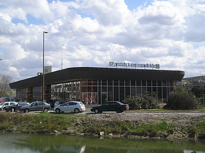
Železniška postaja Koper Address: Kolodvorska cesta 11 street in Koper
Koper railway station (Slovene: Železniška postaja Koper, Italian: Stazione ferroviaria di Capodistria) is a railway station in Koper, Slovenia.Wiki
Places Near Železniška postaja Koper
How to get to popular places in Koper with public transit
Get around Koper by public transit!
Traveling around Koper has never been so easy. See step by step directions as you travel to any attraction, street or major public transit station. View bus and train schedules, arrival times, service alerts and detailed routes on a map, so you know exactly how to get to anywhere in Koper.
When traveling to any destination around Koper use Moovit's Live Directions with Get Off Notifications to know exactly where and how far to walk, how long to wait for your line, and how many stops are left. Moovit will alert you when it's time to get off — no need to constantly re-check whether yours is the next stop.
Wondering how to use public transit in Koper or how to pay for public transit in Koper? Moovit public transit app can help you navigate your way with public transit easily, and at minimum cost. It includes public transit fees, ticket prices, and costs. Looking for a map of Koper public transit lines? Moovit public transit app shows all public transit maps in Koper with all Bus and Train routes and stops on an interactive map.
Koper has 2 transit type(s), including: Bus and Train, operated by several transit agencies, including