Майдан Незалежності stop - Thursday schedule
| Line | Direction | Time |
|---|---|---|
| 6ТР | Діагностичний Центр | 06:10 |
| 18ТР | Вул. Сошенка | 06:30 |
| 16 | Майдан Незалежності | 06:43 |
| 16 | Вул. Академіка Туполєва | 06:45 |
| 18ТР | Майдан Незалежності | 06:45 |
| 18ТР | Вул. Сошенка | 06:48 |
| 6ТР | Майдан Незалежності | 06:55 |
| 6ТР | Діагностичний Центр | 07:02 |
| 16 | Майдан Незалежності | 07:03 |
| 16 | Вул. Академіка Туполєва | 07:04 |
| 18ТР | Майдан Незалежності | 07:10 |
| 18ТР | Вул. Сошенка | 07:13 |
| 6ТР | Майдан Незалежності | 07:17 |
| 16 | Майдан Незалежності | 07:19 |
| 16 | Вул. Академіка Туполєва | 07:20 |
| 6ТР | Діагностичний Центр | 07:24 |
| 18ТР | Майдан Незалежності | 07:35 |
| 16 | Майдан Незалежності | 07:37 |
| 6ТР | Майдан Незалежності | 07:37 |
| 16 | Вул. Академіка Туполєва | 07:38 |
| 18ТР | Вул. Сошенка | 07:42 |
| 6ТР | Діагностичний Центр | 07:47 |
| 18ТР | Майдан Незалежності | 07:50 |
| 16 | Майдан Незалежності | 07:55 |
| 6ТР | Майдан Незалежності | 07:57 |
Directions to Майдан Незалежності stop (Шевченківський Район) with public transit
The following transit lines have routes that pass near Майдан Незалежності
 Bus: 114, 18ТР, 6ТР, 115.
- Train: МЕ.
- Metro: М1, М2, М3.
- Shuttle: 433.
How to get to Майдан Незалежності stop by bus?
Click on the bus route to see step by step directions with maps, line arrival times and updated time schedules.
How to get to Майдан Незалежності stop by train?
Click on the train route to see step by step directions with maps, line arrival times and updated time schedules.
How to get to Майдан Незалежності stop by metro?
Click on the metro route to see step by step directions with maps, line arrival times and updated time schedules.
Bus stops near Майдан Незалежності stop in Шевченківський Район
- Центральний Універмаг, 2 min walk,
- Пам’Ятник Магдебурзькому Праву, 12 min walk,
- Вул. Олеся Гончара, 14 min walk,
Metro stations near Майдан Незалежності station in Шевченківський Район
- Майдан Незалежності, 4 min walk,
- Театральна, 7 min walk,
- Золоті Ворота, 11 min walk,
Shuttle stations near Майдан Незалежності station in Шевченківський Район
- Вул. Терещенківська, 10 min walk,
Bus lines to Майдан Незалежності stop in Шевченківський Район
- 114, Вул. Радунська,
- 115, Контрактова Площа,
- 6ТР, Діагностичний Центр,
- 16, Вул. Академіка Туполєва,
- 18ТР, Вул. Сошенка,
What are the closest stations to Майдан Незалежності?
The closest stations to Майдан Незалежності are:
- Центральний Універмаг is 70 meters away, 2 min walk.
- Майдан Незалежності is 222 meters away, 4 min walk.
- Театральна is 484 meters away, 7 min walk.
- Вул. Терещенківська is 754 meters away, 10 min walk.
- Золоті Ворота is 782 meters away, 11 min walk.
- Пам’Ятник Магдебурзькому Праву is 905 meters away, 12 min walk.
- Вул. Олеся Гончара is 1046 meters away, 14 min walk.
Which bus lines stop near Майдан Незалежності?
These bus lines stop near Майдан Незалежності: 114, 18ТР, 6ТР.
Which train line stops near Майдан Незалежності?
МЕ (Е1 Святошин - Київ-Пас. (Північна) - Дарниця - Почайна - Святошин)
Which metro lines stop near Майдан Незалежності?
These metro lines stop near Майдан Незалежності: М1, М2, М3.
What’s the nearest metro station to Майдан Незалежності in Шевченківський Район?
The nearest metro station to Майдан Незалежності in Шевченківський Район is Майдан Незалежності. It’s a 4 min walk away.
What’s the nearest bus station to Майдан Незалежності in Шевченківський Район?
The nearest bus station to Майдан Незалежності in Шевченківський Район is Центральний Універмаг. It’s a 2 min walk away.
What’s the nearest shuttle station to Майдан Незалежності in Шевченківський Район?
The nearest shuttle station to Майдан Незалежності in Шевченківський Район is Вул. Терещенківська. It’s a 10 min walk away.
What time is the first metro to Майдан Незалежності in Шевченківський Район?
The М2 is the first metro that goes to Майдан Незалежності in Шевченківський Район. It stops nearby at 5:45 AM.
What time is the last metro to Майдан Незалежності in Шевченківський Район?
The М3 is the last metro that goes to Майдан Незалежності in Шевченківський Район. It stops nearby at 9:55 PM.
What time is the first bus to Майдан Незалежності in Шевченківський Район?
The 6ТР is the first bus that goes to Майдан Незалежності in Шевченківський Район. It stops nearby at 6:12 AM.
What time is the last bus to Майдан Незалежності in Шевченківський Район?
The 18ТР is the last bus that goes to Майдан Незалежності in Шевченківський Район. It stops nearby at 9:36 PM.
What time is the first Trolleybus to Майдан Незалежності in Шевченківський Район?
The 16 is the first Trolleybus that goes to Майдан Незалежності in Шевченківський Район. It stops nearby at 6:38 AM.
What time is the last Trolleybus to Майдан Незалежності in Шевченківський Район?
The 16 is the last Trolleybus that goes to Майдан Незалежності in Шевченківський Район. It stops nearby at 9:34 PM.
What time is the first shuttle to Майдан Незалежності in Шевченківський Район?
The 433 is the first shuttle that goes to Майдан Незалежності in Шевченківський Район. It stops nearby at 6:00 AM.
What time is the last shuttle to Майдан Незалежності in Шевченківський Район?
The 433 is the last shuttle that goes to Майдан Незалежності in Шевченківський Район. It stops nearby at 10:17 PM.
Майдан Незалежності station
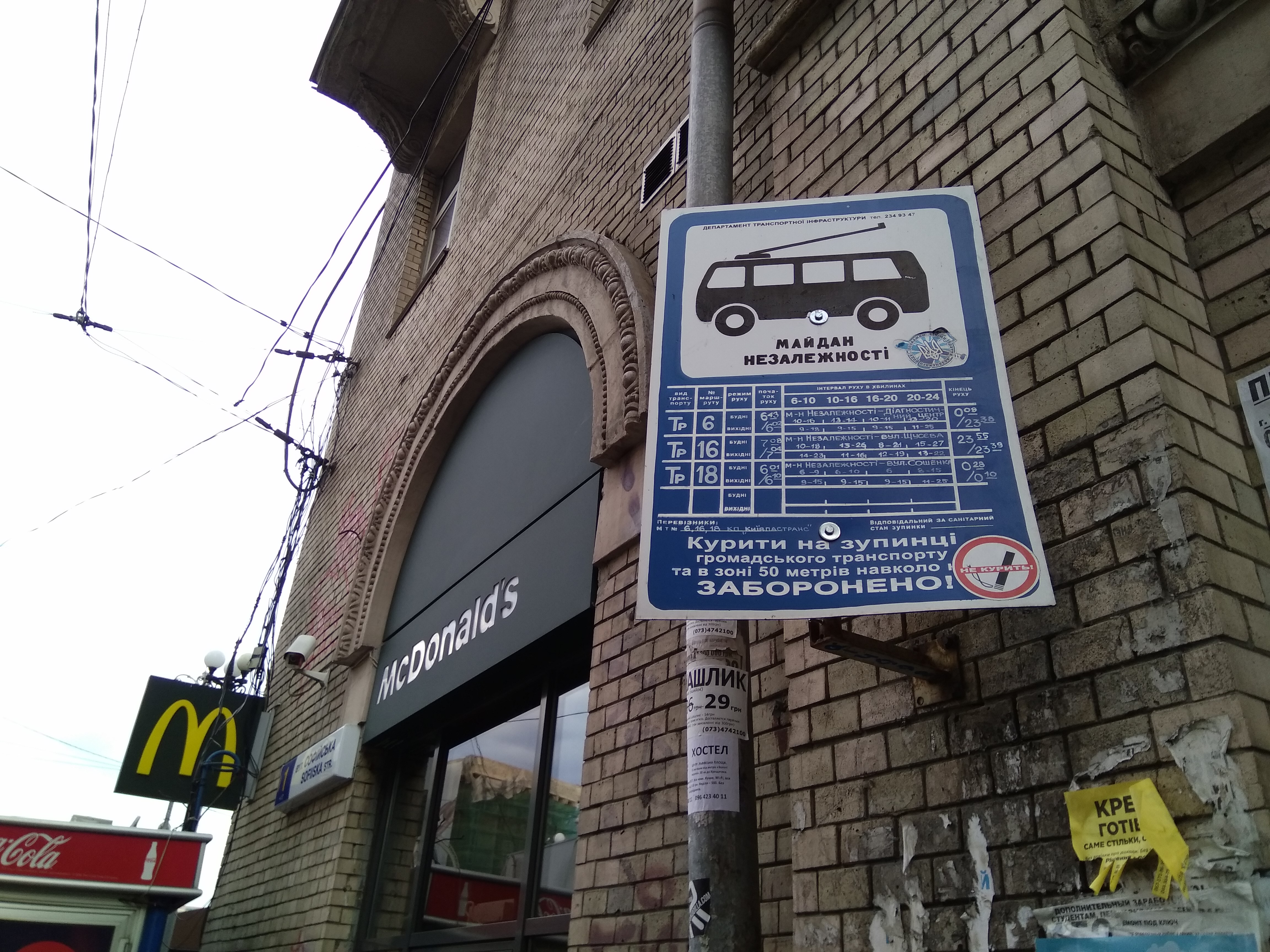 Taken by Александр С.
See Майдан Незалежності stop, Шевченківський Район, on the map
Public transit to Майдан Незалежності stop in Шевченківський Район
Looking for directions to Майдан Незалежності in Шевченківський Район, Ukraine?
Download the Moovit App to find the current schedule and step-by-step directions for Bus, Shuttle, Metro, Light Rail, Train or Trolleybus routes that pass through Майдан Незалежності.
Looking for the nearest stops closest to Майдан Незалежності ? Check out this list of closest stops to your destination: Центральний Універмаг; Майдан Незалежності; Театральна; Вул. Терещенківська; Золоті Ворота; Пам’Ятник Магдебурзькому Праву; Вул. Олеся Гончара.
Bus: 114, 18ТР, 6ТР, 115.Train: МЕ.Metro: М1, М2, М3.Shuttle: 433.
We make riding on public transit to Майдан Незалежності easy, which is why over 1.5 million users, including users in Шевченківський Район trust Moovit as the best app for public transit.
Use the app to navigate to popular places including to the airport, hospital, stadium, grocery store, mall, coffee shop, school, college, and university.
The first line to this stop is 6ТР, at 06:10, and the last line is 18ТР at 21:40.
Independence Square, Київ, Ukraine
This stop serves KP Kyivpastrans and KP Kyivpastrans’s lines
Popular routes from Майдан Незалежності stop, Шевченківський Район
- Центральний Універмаг,
- Пам’Ятник Магдебурзькому Праву,
- Вул. Олеся Гончара
Bus stops near Майдан Незалежності stop
- Майдан Незалежності,
- Театральна,
- Золоті Ворота
Metro stations near Майдан Незалежності station
- Вул. Терещенківська
Shuttle station near Майдан Незалежності station
- Завод Арсенал,
- С. Ревне,
- Вул. Лісківська,
- Мауп,
- Вул. Білоруська,
- Фабрика Киянка,
- Вул. Депутатська,
- Ст. М. Почайна,
- С. Іванковичі (Вул. Леніна),
- Смт Калинівка (Станція Васильків-1),
- Залізничний Вокзал Дарниця,
- Ст. М. Дніпро,
- Вул. Деміївська,
- Вул. Драгоманова,
- Вул. Якуба Коласа,
- С. Хотянівка-1,
- Вул. Шолуденка,
- Станція Буча,
- Станція Борщагівка,
- Станція Київ-Деміївський
Popular public transit stations in Шевченківський Район
Get around Шевченківський Район by public transit!
Traveling around Шевченківський Район has never been so easy. See step by step directions as you travel to any attraction, street or major public transit station. View bus and train schedules, arrival times, service alerts and detailed routes on a map, so you know exactly how to get to anywhere in Шевченківський Район.
When traveling to any destination around Шевченківський Район use Moovit's Live Directions with Get Off Notifications to know exactly where and how far to walk, how long to wait for your line, and how many stops are left. Moovit will alert you when it's time to get off — no need to constantly re-check whether yours is the next stop.
Wondering how to use public transit in Шевченківський Район or how to pay for public transit in Шевченківський Район? Moovit public transit app can help you navigate your way with public transit easily, and at minimum cost. It includes public transit fees, ticket prices, and costs. Looking for a map of Шевченківський Район public transit lines? Moovit public transit app shows all public transit maps in Шевченківський Район with all Bus, Train, Metro, Light Rail, Trolleybus and Shuttle routes and stops on an interactive map.
Kyiv has 6 transit type(s), including: Bus, Train, Metro, Light Rail, Trolleybus and Shuttle, operated by several transit agencies, including Київський метрополітен, КП "Київпастранс", Південно-Західна Залізниця, Бориспіль, Маршрутне таксі, Приміські маршрути and Бровари та район