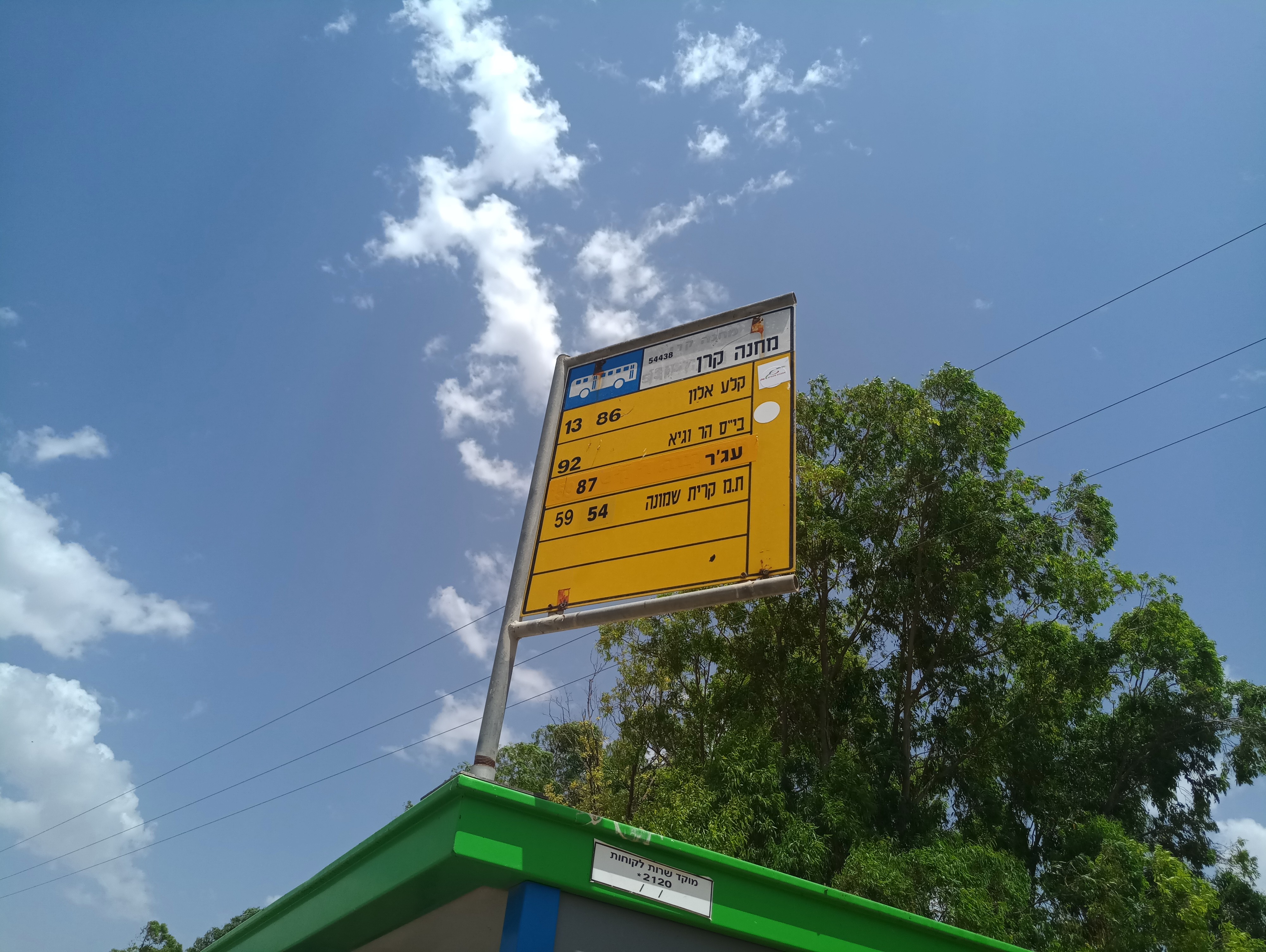
Camp Keren stop - Wednesday schedule
| Line | Direction | Time |
|---|---|---|
| 54 | Kiryat Shmona | 07:27 |
| 92 | Dafna | 07:31 |
| 59 | Kiryat Shmona | 09:42 |
| 13 | Mas'ade | 10:37 |
| 59 | Kiryat Shmona | 11:07 |
| 59 | Kiryat Shmona | 12:22 |
| 13 | Mas'ade | 12:37 |
| 87 | Mas'ade | 13:17 |
| 13 | Mas'ade | 14:07 |
| 54 | Kiryat Shmona | 14:37 |
| 87 | Mas'ade | 15:27 |
| 59 | Kiryat Shmona | 15:47 |
| 59 | Kiryat Shmona | 16:52 |
| 13 | Mas'ade | 17:12 |
| 13 | Mas'ade | 18:32 |
| 59 | Kiryat Shmona | 19:27 |
| 13 | Mas'ade | 20:57 |
Directions to Camp Keren stop (Golan) with public transit
The following transit lines have routes that pass near Camp Keren
 Bus: 59, 81, 13, 54, 87.
How to get to Camp Keren stop by bus?
Click on the bus route to see step by step directions with maps, line arrival times and updated time schedules.
Bus stops near Camp Keren stop in Golan
- Camp Keren, 2 min walk,
Bus lines to Camp Keren stop in Golan
- 13, Mas'ade,
- 54, Kiryat Shmona,
- 59, Katzrin,
- 87, Mas'ade,
- 92, Katzrin,
What are the closest stations to Camp Keren?
The closest stations to Camp Keren are:
- Camp Keren is 96 meters away, 2 min walk.
Which bus lines stop near Camp Keren?
These bus lines stop near Camp Keren: 59, 81.
What’s the nearest bus station to Camp Keren in Golan?
The nearest bus station to Camp Keren in Golan is Camp Keren. It’s a 2 min walk away.
What time is the first bus to Camp Keren in Golan?
The 54 is the first bus that goes to Camp Keren in Golan. It stops nearby at 7:24 AM.
What time is the last bus to Camp Keren in Golan?
The 59 is the last bus that goes to Camp Keren in Golan. It stops nearby at 10:26 PM.
Camp Keren station
 Taken by Adam P.
See Camp Keren stop, Golan, on the map
Public transit to Camp Keren stop (ID: 54438) in Golan
Looking for directions to Camp Keren in Golan, Israel?
Download the Moovit App to find the current schedule and step-by-step directions for Bus routes that pass through Camp Keren.
Looking for the nearest stops closest to Camp Keren ? Check out this list of closest stops to your destination: Camp Keren.
Bus: 59, 81, 13, 54, 87, 92.
We make riding on public transit to Camp Keren easy, which is why over 1.5 million users, including users in Golan trust Moovit as the best app for public transit.
Use the app to navigate to popular places including to the airport, hospital, stadium, grocery store, mall, coffee shop, school, college, and university.
Camp Keren stop’s code is 54438
The first line to this stop is 54, at 07:27, and the last line is 13 at 20:57.
This stop serves Golan Regional Council’s lines
- Camp Keren
Bus stop near Camp Keren stop
- Rosh Pina Central Station,
- Urim East Junction/Road 234,
- Beit Yehoshua Train Station,
- Segula North Junction/Road 40,
- Ashdod Port Junction,
- Kama Interchange South,
- Shilat Junction,
- Alonim Junction,
- Bnei Zion Hospital/Golomb,
- Golani Base,
- Bar Ilan University,
- Eshkol Regional Council Junction,
- Beit Rivka,
- Aviation Industry Junction,
- HaOman/HaSadna,
- Rabbi of Zvhill/Ma'alot Gaonei Brisk,
- Camp Tze'elim,
- Jerusalem/Golani Brigade,
- Operational Station Parking 4/9,
- Galilee Medical Center
Popular public transit stations in Golan
Get around Golan by public transit!
Traveling around Golan has never been so easy. See step by step directions as you travel to any attraction, street or major public transit station. View bus and train schedules, arrival times, service alerts and detailed routes on a map, so you know exactly how to get to anywhere in Golan.
When traveling to any destination around Golan use Moovit's Live Directions with Get Off Notifications to know exactly where and how far to walk, how long to wait for your line, and how many stops are left. Moovit will alert you when it's time to get off — no need to constantly re-check whether yours is the next stop.
Wondering how to use public transit in Golan or how to pay for public transit in Golan? Moovit public transit app can help you navigate your way with public transit easily, and at minimum cost. It includes public transit fees, ticket prices, and costs. Looking for a map of Golan public transit lines? Moovit public transit app shows all public transit maps in Golan with all Bus, Israel Railways, Light Rail, Carmelit / Rachbalit and Shuttle routes and stops on an interactive map.
Israel has 5 transit type(s), including: Bus, Israel Railways, Light Rail, Carmelit / Rachbalit and Shuttle, operated by several transit agencies, including Dan, Tel Aviv Light Rail - Tevel - Red Line, Israel Railways, Egged, Metropoline, Kavim, Electra Afikim, Nateev Express, Extra, Extra Jerusalem, Jerusalem Light Rail - Kfir, Egged Jerusalem Envelope Route, Dan Badarom, Dan Beer-Sheva and Electra Afikim Transport