Snir Junction stop - Friday schedule
| Line | Direction | Time |
|---|---|---|
| 37 | Ein Qiniyye | 07:02 |
| 358 | Mas'ade | 08:12 |
| 37 | Ein Qiniyye | 08:57 |
| 358 | Mas'ade | 10:12 |
| 37 | Ein Qiniyye | 10:52 |
| 358 | Mas'ade | 12:12 |
| 37 | Ein Qiniyye | 12:42 |
| 358 | Mas'ade | 13:57 |
| 37 | Ein Qiniyye | 14:32 |
| 58 | El-Rom | 15:12 |
Directions to Snir Junction stop (HaGalil HaElyon) with public transit
The following transit lines have routes that pass near Snir Junction
 Bus: 358, 37, 36, 58, 95.
How to get to Snir Junction stop by bus?
Click on the bus route to see step by step directions with maps, line arrival times and updated time schedules.
Bus stops near Snir Junction stop in HaGalil HaElyon
- Snir Junction, 1 min walk,
Bus lines to Snir Junction stop in HaGalil HaElyon
- 36, Snir,
- 37, Ein Qiniyye,
- 58, El-Rom,
- 95, Dafna,
- 358, Mas'ade,
What are the closest stations to Snir Junction?
The closest stations to Snir Junction are:
- Snir Junction is 21 meters away, 1 min walk.
Which bus lines stop near Snir Junction?
These bus lines stop near Snir Junction: 358, 37.
What’s the nearest bus station to Snir Junction in HaGalil HaElyon?
The nearest bus station to Snir Junction in HaGalil HaElyon is Snir Junction. It’s a 1 min walk away.
What time is the first bus to Snir Junction in HaGalil HaElyon?
The 37 is the first bus that goes to Snir Junction in HaGalil HaElyon. It stops nearby at 5:44 AM.
What time is the last bus to Snir Junction in HaGalil HaElyon?
The 58 is the last bus that goes to Snir Junction in HaGalil HaElyon. It stops nearby at 10:12 PM.
Snir Junction station
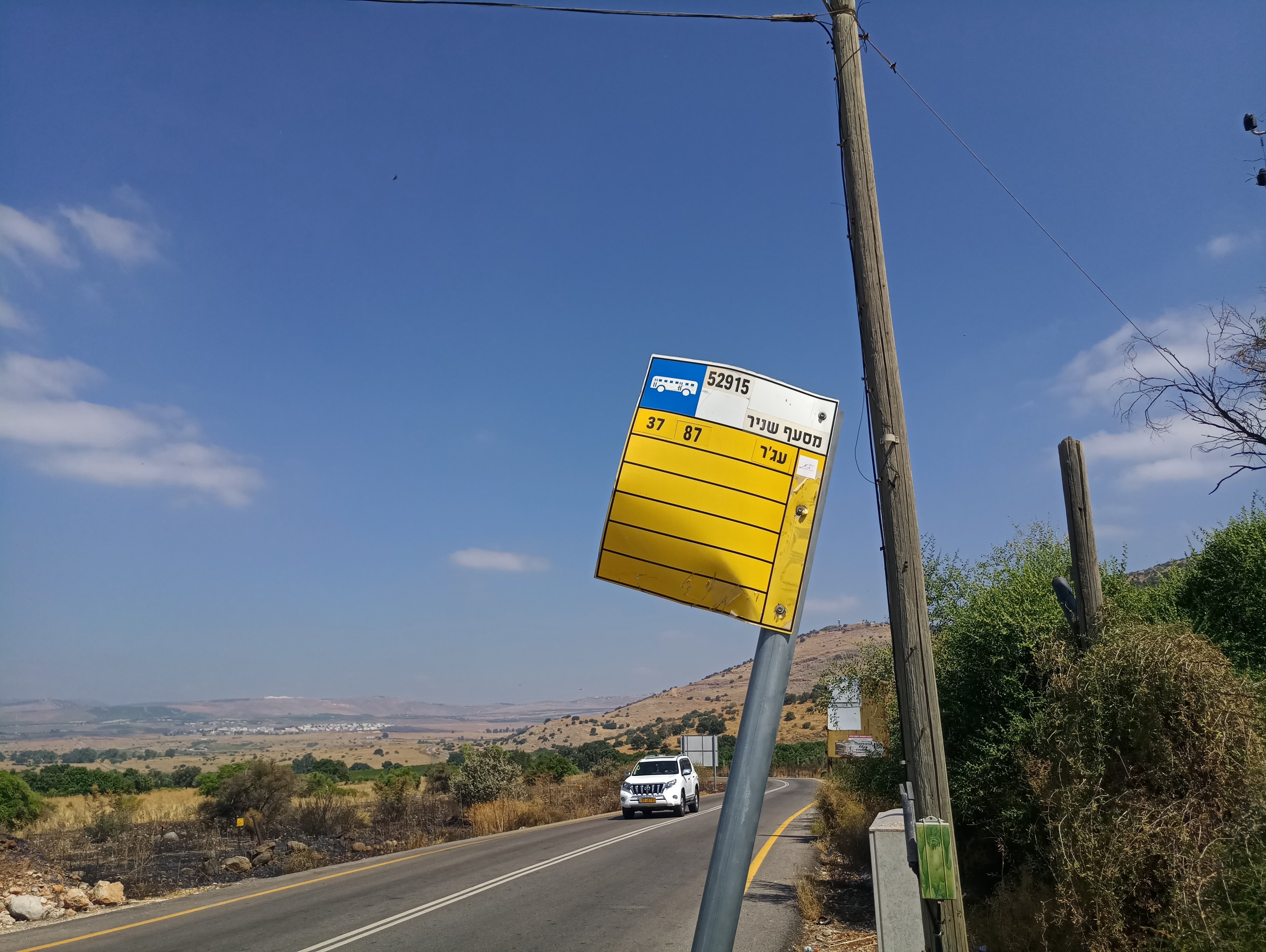 Taken by Adam P.
See Snir Junction stop, HaGalil HaElyon, on the map
Public transit to Snir Junction stop (ID: 52915) in HaGalil HaElyon
Looking for directions to Snir Junction in HaGalil HaElyon, Israel?
Download the Moovit App to find the current schedule and step-by-step directions for Bus routes that pass through Snir Junction.
Looking for the nearest stops closest to Snir Junction ? Check out this list of closest stops to your destination: Snir Junction.
Bus: 358, 37, 36, 58, 95.
We make riding on public transit to Snir Junction easy, which is why over 1.5 million users, including users in HaGalil HaElyon trust Moovit as the best app for public transit.
Use the app to navigate to popular places including to the airport, hospital, stadium, grocery store, mall, coffee shop, school, college, and university.
Snir Junction stop’s code is 52915
The first line to this stop is 37, at 07:02, and the last line is 58 at 15:12.
This stop serves Golan Regional Council’s lines
- Snir Junction
Bus stop near Snir Junction stop
- Shaar Menashe,
- New Lod Cemetery,
- Camp Matzlach 6820,
- Tel Nof Base,
- Meron Junction,
- Cave of the Patriarchs,
- Fliman Hospital,
- Givat Shmuel Interchange/Mivtza Kadesh,
- Weizmann Institute,
- Milano Square/Ibn Gabirol,
- Desert Wind,
- Zichron Yaakov/Rishon LeZion,
- Rishon LeZion/Rehovot,
- Hatzor HaGlilit Terminal,
- Ma'on Junction,
- Pardes Chaim Cemetery,
- Camp Shraga,
- Machane Natan/Totzeret HaAretz,
- Kryon,
- Jerusalem Central Station Level 3/Platforms
Popular public transit stations in HaGalil HaElyon
Get around HaGalil HaElyon by public transit!
Traveling around HaGalil HaElyon has never been so easy. See step by step directions as you travel to any attraction, street or major public transit station. View bus and train schedules, arrival times, service alerts and detailed routes on a map, so you know exactly how to get to anywhere in HaGalil HaElyon.
When traveling to any destination around HaGalil HaElyon use Moovit's Live Directions with Get Off Notifications to know exactly where and how far to walk, how long to wait for your line, and how many stops are left. Moovit will alert you when it's time to get off — no need to constantly re-check whether yours is the next stop.
Wondering how to use public transit in HaGalil HaElyon or how to pay for public transit in HaGalil HaElyon? Moovit public transit app can help you navigate your way with public transit easily, and at minimum cost. It includes public transit fees, ticket prices, and costs. Looking for a map of HaGalil HaElyon public transit lines? Moovit public transit app shows all public transit maps in HaGalil HaElyon with all Bus, Israel Railways, Light Rail, Carmelit / Rachbalit and Shuttle routes and stops on an interactive map.
Israel has 5 transit type(s), including: Bus, Israel Railways, Light Rail, Carmelit / Rachbalit and Shuttle, operated by several transit agencies, including Dan, Tel Aviv Light Rail - Tevel - Red Line, Israel Railways, Egged, Metropoline, Kavim, Electra Afikim, Nateev Express, Extra, Extra Jerusalem, Jerusalem Light Rail - Kfir, Egged Jerusalem Envelope Route, Dan Badarom, Dan Beer-Sheva and Electra Afikim Transport