Nitzan/Nirit stop - Friday schedule
| Line | Direction | Time |
|---|---|---|
| 1A | Transportation Center/Shlomi | 05:28 |
| 22 | Nahariya Central Station/Drop Off | 05:29 |
| 1 | Transportation Center/Shlomi | 05:48 |
| 1A | Transportation Center/Shlomi | 06:13 |
| 22 | Nahariya Central Station/Drop Off | 06:29 |
| 1 | Transportation Center/Shlomi | 06:33 |
| 1A | Transportation Center/Shlomi | 06:53 |
| 1 | Transportation Center/Shlomi | 07:13 |
| 22 | Nahariya Central Station/Drop Off | 07:29 |
| 1A | Transportation Center/Shlomi | 07:33 |
| 1 | Transportation Center/Shlomi | 07:53 |
| 22 | Nahariya Central Station/Drop Off | 08:29 |
| 1A | Transportation Center/Shlomi | 08:43 |
| 1 | Transportation Center/Shlomi | 09:03 |
| 1A | Transportation Center/Shlomi | 09:28 |
| 22 | Nahariya Central Station/Drop Off | 09:29 |
| 1 | Transportation Center/Shlomi | 09:48 |
| 1A | Transportation Center/Shlomi | 10:13 |
| 22 | Nahariya Central Station/Drop Off | 10:29 |
| 1 | Transportation Center/Shlomi | 10:33 |
| 1A | Transportation Center/Shlomi | 10:58 |
| 1 | Transportation Center/Shlomi | 11:18 |
| 22 | Nahariya Central Station/Drop Off | 11:29 |
| 1A | Transportation Center/Shlomi | 11:43 |
| 1 | Transportation Center/Shlomi | 12:03 |
Directions to Nitzan/Nirit stop (Shlomi) with public transit
The following transit lines have routes that pass near Nitzan/Nirit
 Bus: 22, 28, 36, 1, 1A.
How to get to Nitzan/Nirit stop by bus?
Click on the bus route to see step by step directions with maps, line arrival times and updated time schedules.
Bus stops near Nitzan/Nirit stop in Shlomi
- Yasmin/Nitzan, 4 min walk,
- Hanita Forest/Yasmin, 7 min walk,
- Dror/Rakefet, 9 min walk,
Bus lines to Nitzan/Nirit stop in Shlomi
- 1, Transportation Center/Shlomi,
- 1A, Transportation Center/Shlomi,
- 22, Nahariya Central Station/Drop Off,
- 31, Nahariya,
- 36, Nahariya,
What are the closest stations to Nitzan/Nirit?
The closest stations to Nitzan/Nirit are:
- Yasmin/Nitzan is 280 meters away, 4 min walk.
- Hanita Forest/Yasmin is 526 meters away, 7 min walk.
- Dror/Rakefet is 660 meters away, 9 min walk.
Which bus lines stop near Nitzan/Nirit?
These bus lines stop near Nitzan/Nirit: 22, 28, 36.
What’s the nearest bus station to Nitzan/Nirit in Shlomi?
The nearest bus station to Nitzan/Nirit in Shlomi is Yasmin/Nitzan. It’s a 4 min walk away.
What time is the first bus to Nitzan/Nirit in Shlomi?
The 1A is the first bus that goes to Nitzan/Nirit in Shlomi. It stops nearby at 5:18 AM.
What time is the last bus to Nitzan/Nirit in Shlomi?
The 1 is the last bus that goes to Nitzan/Nirit in Shlomi. It stops nearby at 11:53 PM.
Nitzan/Nirit station
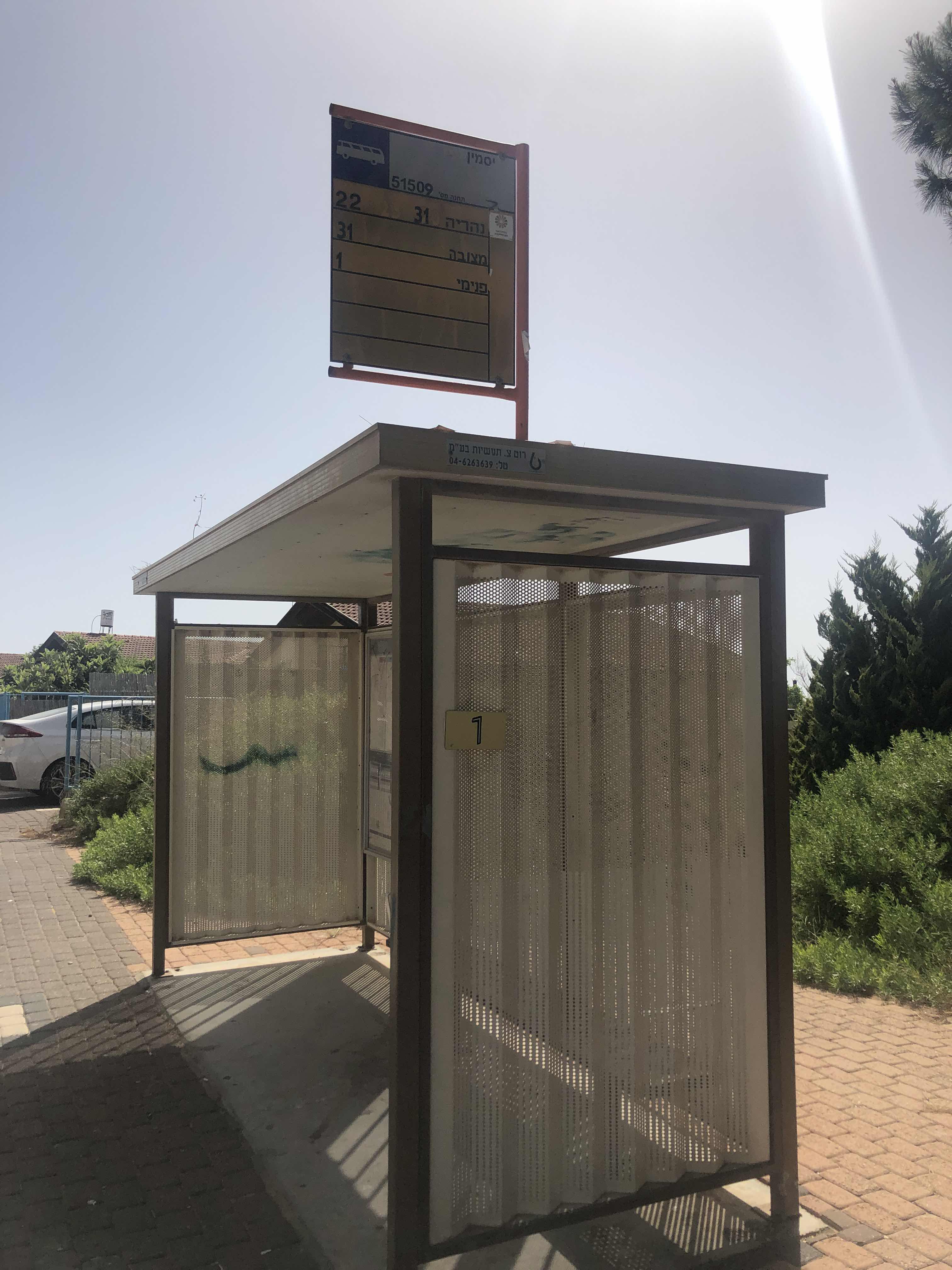 Taken by דניאל מ.
See Nitzan/Nirit stop, Shlomi, on the map
Public transit to Nitzan/Nirit stop (ID: 51509) in Shlomi
Looking for directions to Nitzan/Nirit in Shlomi, Israel?
Download the Moovit App to find the current schedule and step-by-step directions for Bus routes that pass through Nitzan/Nirit.
Looking for the nearest stops closest to Nitzan/Nirit ? Check out this list of closest stops to your destination: Yasmin/Nitzan; Hanita Forest/Yasmin; Dror/Rakefet.
Bus: 22, 28, 36, 1, 1A, 31.
We make riding on public transit to Nitzan/Nirit easy, which is why over 1.5 million users, including users in Shlomi trust Moovit as the best app for public transit.
Use the app to navigate to popular places including to the airport, hospital, stadium, grocery store, mall, coffee shop, school, college, and university.
Nitzan/Nirit stop’s code is 51509
The first line to this stop is 1A, at 05:28, and the last line is 1 at 16:13.
Nitsan
This stop serves Nateev Express’s lines
- Yasmin/Nitzan,
- Hanita Forest/Yasmin,
- Dror/Rakefet
Bus stops near Nitzan/Nirit stop
- Agmon HaHula,
- Azrieli Mall/Menachem Begin Road,
- Mitzpe Modi'in Junction,
- Tel Aviv - Savidor Train Station/Park and Ride,
- Galilee Medical Center,
- Kfar Monash,
- Kiryat Anavim/Cramim Hotel,
- Education Campus/Shoshana Persitz,
- Nir Etzion,
- Teddy Stadium/Beitar,
- Saad Junction,
- Holon Wolfson Station,
- Arches Beach,
- Camp Sagov/Har Berech,
- Nachshonim B,
- Ofakim Railway Station,
- Geha Junction/Jabotinsky Road,
- HaZahav Mall Terminal,
- Kupat Holim C/Henrietta Szold,
- Kryon
Popular public transit stations in Shlomi
Get around Shlomi by public transit!
Traveling around Shlomi has never been so easy. See step by step directions as you travel to any attraction, street or major public transit station. View bus and train schedules, arrival times, service alerts and detailed routes on a map, so you know exactly how to get to anywhere in Shlomi.
When traveling to any destination around Shlomi use Moovit's Live Directions with Get Off Notifications to know exactly where and how far to walk, how long to wait for your line, and how many stops are left. Moovit will alert you when it's time to get off — no need to constantly re-check whether yours is the next stop.
Wondering how to use public transit in Shlomi or how to pay for public transit in Shlomi? Moovit public transit app can help you navigate your way with public transit easily, and at minimum cost. It includes public transit fees, ticket prices, and costs. Looking for a map of Shlomi public transit lines? Moovit public transit app shows all public transit maps in Shlomi with all Bus, Israel Railways, Light Rail, Carmelit / Rachbalit and Shuttle routes and stops on an interactive map.
Israel has 5 transit type(s), including: Bus, Israel Railways, Light Rail, Carmelit / Rachbalit and Shuttle, operated by several transit agencies, including Dan, Tel Aviv Light Rail - Tevel - Red Line, Israel Railways, Egged, Metropoline, Kavim, Electra Afikim, Nateev Express, Extra, Extra Jerusalem, Jerusalem Light Rail - Kfir, Egged Jerusalem Envelope Route, Dan Badarom, Dan Beer-Sheva and Electra Afikim Transport