Directions to ท่าเรือสี่พระยา (บางรัก) with public transportation
The following transit lines have routes that pass near ท่าเรือสี่พระยา
How to get to ท่าเรือสี่พระยา by bus?
Click on the bus route to see step by step directions with maps, line arrival times and updated time schedules.
How to get to ท่าเรือสี่พระยา by train?
Click on the train route to see step by step directions with maps, line arrival times and updated time schedules.
How to get to ท่าเรือสี่พระยา by metro?
Click on the metro route to see step by step directions with maps, line arrival times and updated time schedules.
How to get to ท่าเรือสี่พระยา by SkyTrain?
Click on the SkyTrain route to see step by step directions with maps, line arrival times and updated time schedules.
How to get to ท่าเรือสี่พระยา by ferry?
Click on the ferry route to see step by step directions with maps, line arrival times and updated time schedules.
Bus stops near ท่าเรือสี่พระยา in บางรัก
- ตลาดน้อย Talat Noi, 1 min walk,
- วัดมหาพฤฒาราม WAT Mahapruttaram, 4 min walk,
- อาคารเกียรตินาคิน Arkan Kieat Nakin, 6 min walk,
- ท่าน้ำสี่พระยา Si Phraya Pier, 7 min walk,
- ตลาดคลองสาน Klongsan Market, 42 min walk,
- ตรงข้ามตลาดคลองสาน/ไอคอนสยาม;Opposite Klongsan Market / Icon Siam, 42 min walk,
- ตลาดคลองสาน /ไอคอนสยาม;Klongsan Market / Iconsiam, 43 min walk,
- ตรงข้ามตลาดคลองสาน Opp Klongsan Market, 43 min walk,
- หลังแยกเจริญรัถ;After Charoen Rat Junction, 45 min walk,
- จุดขึ้นลง;Visual Stop, 47 min walk,
Ferry stations near ท่าเรือสี่พระยา in บางรัก
- ท่าเรือกรมเจ้าท่า;Marine Department Pier, 5 min walk,
- ท่าเรือสี่พระยา (ข้ามฟาก);Si Phraya Pier (Ferry), 8 min walk,
Bus lines to ท่าเรือสี่พระยา in บางรัก
- 1, ถนนตก;Thanon Tok,
- 3-52R, พระราม 3 วนขวา;Rama 3 R,
- 3-35 (1), ท่าเตียน;Tha Tien,
- 4-13 (75), หัวลำโพง;Hua Lamphong,
- 4-19 (108L), เดอะมอลล์ท่าพระ วนซ้าย;The Mall Tha Phra L,
- 1, วัดโพธิ์ท่าเตียน Tha Tian,
- 1, หน่วยบัญชาการรักษาดินแดน,
- 75, แยกหัวลำโพง Hua Lamphong Intersection,
- 75, ซอยพุทธบูชา 39 Pamnam Man Pototho Phut Bucha,
- 3-52L, พระราม 3 วนซ้าย;Rama 3 L,
- 4-19 (108R), เดอะมอลล์ท่าพระ (วนขวา);The Mall Tha Phra R,
- 2-2, ท่าเรือปากเกร็ด; Pak Kret Pier,
- 3-9E (45), หนามแดง;Namdaeng,
- 4-8 (35), บางลำพู;Bang Lamphu,
- 1-40 (93), หมู่บ้านนักกีฬา;Nakkila Village,
- 2-40 (36), อู่พระราม 9;Rama 9,
- 3-10 (46), อู่รามคำแหง 2 ;Ramkhamhaeng 2 Bus Terminal,
- 1-55E (514 ทางด่วน), อู่มีนบุรี;Minburi,
- 16, สภากาชาดไทย the Thai Red Cross Society,
- 16 (ปอ.) (AC), สภากาชาดไทย the Thai Red Cross Society,
What are the closest stations to ท่าเรือสี่พระยา?
The closest stations to ท่าเรือสี่พระยา are:
- ตลาดน้อย Talat Noi is 64 meters away, 1 min walk.
- วัดมหาพฤฒาราม WAT Mahapruttaram is 256 meters away, 4 min walk.
- ท่าเรือกรมเจ้าท่า;Marine Department Pier is 350 meters away, 5 min walk.
- อาคารเกียรตินาคิน Arkan Kieat Nakin is 429 meters away, 6 min walk.
- ท่าน้ำสี่พระยา Si Phraya Pier is 494 meters away, 7 min walk.
- ท่าเรือสี่พระยา (ข้ามฟาก);Si Phraya Pier (Ferry) is 549 meters away, 8 min walk.
- ตลาดคลองสาน Klongsan Market is 3230 meters away, 42 min walk.
- ตรงข้ามตลาดคลองสาน/ไอคอนสยาม;Opposite Klongsan Market / Icon Siam is 3258 meters away, 42 min walk.
- ตลาดคลองสาน /ไอคอนสยาม;Klongsan Market / Iconsiam is 3276 meters away, 43 min walk.
- ตรงข้ามตลาดคลองสาน Opp Klongsan Market is 3311 meters away, 43 min walk.
- หลังแยกเจริญรัถ;After Charoen Rat Junction is 3414 meters away, 45 min walk.
- จุดขึ้นลง;Visual Stop is 3636 meters away, 47 min walk.
Which bus lines stop near ท่าเรือสี่พระยา?
These bus lines stop near ท่าเรือสี่พระยา: 16, 3-10 (46), 3-35 (1), 36 (ปอ.) (AC), 93.
Which train lines stop near ท่าเรือสี่พระยา?
These train lines stop near ท่าเรือสี่พระยา: 318, 378.
Which metro line stops near ท่าเรือสี่พระยา?
BLUE (บางหว้า (วันเสาร์);Bang Wa (Saturday))
Which SkyTrain line stops near ท่าเรือสี่พระยา?
SILOM (บางหว้า;Bang Wa)
Which ferry lines stop near ท่าเรือสี่พระยา?
These ferry lines stop near ท่าเรือสี่พระยา: URBAN LINE, เรือคลองแสนแสบ.
What’s the nearest bus station to ท่าเรือสี่พระยา in บางรัก?
The nearest bus station to ท่าเรือสี่พระยา in บางรัก is ตลาดน้อย Talat Noi. It’s a 1 min walk away.
What’s the nearest ferry station to ท่าเรือสี่พระยา in บางรัก?
The nearest ferry station to ท่าเรือสี่พระยา in บางรัก is ท่าเรือกรมเจ้าท่า;Marine Department Pier. It’s a 5 min walk away.
What time is the first bus to ท่าเรือสี่พระยา in บางรัก?
The 84 is the first bus that goes to ท่าเรือสี่พระยา in บางรัก. It stops nearby at 3:02 AM.
What time is the last bus to ท่าเรือสี่พระยา in บางรัก?
The 84 is the last bus that goes to ท่าเรือสี่พระยา in บางรัก. It stops nearby at 3:42 AM.
What time is the first ferry to ท่าเรือสี่พระยา in บางรัก?
The เรือข้ามฟาก is the first ferry that goes to ท่าเรือสี่พระยา in บางรัก. It stops nearby at 5:00 AM.
What time is the last ferry to ท่าเรือสี่พระยา in บางรัก?
The เรือด่วนธงส้ม is the last ferry that goes to ท่าเรือสี่พระยา in บางรัก. It stops nearby at 7:54 PM.
See ท่าเรือสี่พระยา, บางรัก, on the map
Public Transit to ท่าเรือสี่พระยา in บางรัก
Wondering how to get to ท่าเรือสี่พระยา in บางรัก? Moovit helps you find the best way to get to ท่าเรือสี่พระยา with step-by-step directions from the nearest public transit station.
Moovit provides free maps and live directions to help you navigate through your city. View schedules, routes, timetables, and find out how long does it take to get to ท่าเรือสี่พระยา in real time.
Looking for the nearest stop or station to ท่าเรือสี่พระยา? Check out this list of stops closest to your destination: ตลาดน้อย Talat Noi; วัดมหาพฤฒาราม WAT Mahapruttaram; ท่าเรือกรมเจ้าท่า;Marine Department Pier; อาคารเกียรตินาคิน Arkan Kieat Nakin; ท่าน้ำสี่พระยา Si Phraya Pier; ท่าเรือสี่พระยา (ข้ามฟาก);Si Phraya Pier (Ferry); ตลาดคลองสาน Klongsan Market; ตรงข้ามตลาดคลองสาน/ไอคอนสยาม;Opposite Klongsan Market / Icon Siam; ตลาดคลองสาน /ไอคอนสยาม;Klongsan Market / Iconsiam; ตรงข้ามตลาดคลองสาน Opp Klongsan Market; หลังแยกเจริญรัถ;After Charoen Rat Junction; จุดขึ้นลง;Visual Stop.
Bus: 16, 3-10 (46), 3-35 (1), 36 (ปอ.) (AC), 93, 1, 3-52R, 4-13 (75), 4-19 (108L), 3-52L, 4-19 (108R), 2-2, 3-9E (45), 4-8 (35), 1-40 (93), 2-40 (36), 6, 6 (ปอ.) (AC), 84, 84 (ปอ.) (AC), 88.Train: 318, 378.Metro: BLUE.SkyTrain: SILOM.Ferry: URBAN LINE, เรือคลองแสนแสบ, เรือด่วนธงส้ม, เรือด่วนธงเขียวเหลือง, เรือด่วนธงเหลือง, เรือด่วนธงเหลือง (กลางวัน).
Want to see if there’s another route that gets you there at an earlier time? Moovit helps you find alternative routes or times. Get directions from and directions to ท่าเรือสี่พระยา easily from the Moovit App or Website.
We make riding to ท่าเรือสี่พระยา easy, which is why over 1.5 million users, including users in บางรัก, trust Moovit as the best app for public transit. You don’t need to download an individual bus app or train app, Moovit is your all-in-one transit app that helps you find the best bus time or train time available.
For information on prices of bus, metro, ferry, SkyTrain and train, costs and ride fares to ท่าเรือสี่พระยา, please check the Moovit app.
Use the app to navigate to popular places including to the airport, hospital, stadium, grocery store, mall, coffee shop, school, college, and university.
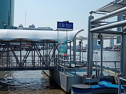
ท่าเรือสี่พระยา Address: ซอยเจริญกรุง 30 street in บางรัก
Places Near ท่าเรือสี่พระยา (บางรัก)
How to get to popular places in Bangkok with public transit
Get around บางรัก by public transit!
Traveling around บางรัก has never been so easy. See step by step directions as you travel to any attraction, street or major public transit station. View bus and train schedules, arrival times, service alerts and detailed routes on a map, so you know exactly how to get to anywhere in บางรัก.
When traveling to any destination around บางรัก use Moovit's Live Directions with Get Off Notifications to know exactly where and how far to walk, how long to wait for your line, and how many stops are left. Moovit will alert you when it's time to get off — no need to constantly re-check whether yours is the next stop.
Wondering how to use public transit in บางรัก or how to pay for public transit in บางรัก? Moovit public transit app can help you navigate your way with public transit easily, and at minimum cost. It includes public transit fees, ticket prices, and costs. Looking for a map of บางรัก public transit lines? Moovit public transit app shows all public transit maps in บางรัก with all Bus, Train, Metro, SkyTrain and Ferry routes and stops on an interactive map.
Bangkok has 5 transit type(s), including: Bus, Train, Metro, SkyTrain and Ferry, operated by several transit agencies, including บีทีเอส BTS, MRT, ไทย สมายล์ บัส;Thai Smile Bus, ขสมก. BMTA, รถไฟฟ้ารฟท. SRTET, รถประจำทาง Transport Bus, บีอาร์ที BRT, เรือคลองโดยสาร Canal Ferry, เรือข้ามฟาก River Ferry, รถสองแถว Songthaew, จุฬาป๊อบบัส Chula Pop Bus, ขสมก BMTA, ขสมก. (BMTA), รถมินิบัส Minibus and รฟท. SRT