Directions to สถานีรถไฟกรุงเทพ (ปทุมวัน) with public transportation
The following transit lines have routes that pass near สถานีรถไฟกรุงเทพ
How to get to สถานีรถไฟกรุงเทพ by bus?
Click on the bus route to see step by step directions with maps, line arrival times and updated time schedules.
How to get to สถานีรถไฟกรุงเทพ by train?
Click on the train route to see step by step directions with maps, line arrival times and updated time schedules.
How to get to สถานีรถไฟกรุงเทพ by metro?
Click on the metro route to see step by step directions with maps, line arrival times and updated time schedules.
How to get to สถานีรถไฟกรุงเทพ by SkyTrain?
Click on the SkyTrain route to see step by step directions with maps, line arrival times and updated time schedules.
How to get to สถานีรถไฟกรุงเทพ by ferry?
Click on the ferry route to see step by step directions with maps, line arrival times and updated time schedules.
Bus stops near สถานีรถไฟกรุงเทพ in ปทุมวัน
- ท่าปล่อยรถ หัวลำโพง Hua Lamphong Bus Terminal, 3 min walk,
- สถานีรถไฟหัวลำโพง Hua Lamphong, 3 min walk,
- วัดดวงแข WAT Duangkhae, 3 min walk,
- หัวลำโพง (ฝั่งรองเมือง);Hua Lamphong (Rong Mueang Side), 4 min walk,
- (สถานี Mrt หัวลำโพง) (Mrt Hua Lamphong Station), 5 min walk,
- Mrt หัวลำโพง(ทางออก 3) Mrt Hua Lamphong (Exit 3), 7 min walk,
- Mrt หัวลำโพง (ทางออก 3);Mrt Hua Lamphong (Exit 3), 7 min walk,
- ไมตรีจิตต์ Maitri Chit, 8 min walk,
- หลังวงเวียน 22 กรกฎา (ฝั่งมิตรพันธ์);After Wong Wian 22 Karakada (Mitphan Side), 9 min walk,
Train station near สถานีรถไฟกรุงเทพ in ปทุมวัน
- Srt กรุงเทพ;Srt Bangkok, 3 min walk,
Ferry station near สถานีรถไฟกรุงเทพ in ปทุมวัน
- ท่าเรือสถานีรถไฟหัวลำโพง;Hua Lamphong Railway Station Pier, 5 min walk,
Metro station near สถานีรถไฟกรุงเทพ in ปทุมวัน
- Mrt หัวลำโพง;Mrt Hua Lamphong, 6 min walk,
Bus lines to สถานีรถไฟกรุงเทพ in ปทุมวัน
- 34, รังสิต - หัวลำโพง;Rangsit - Hua Lamphong,
- 1-1 (29), บางเขน - หัวลำโพง;Bang Khen - Vibhavadi Rangsit - Hua Lamphong,
- 1-2E (34E), รังสิต - หัวลำโพง;Rangsit - Hua Lamphong,
- 1-3 (34เสริม), บางเขน - ถนนพหลโยธิน - หัวลำโพง;Bang Khen -Phaholyothin Rd. - Hua Lamphong,
- 1-44 (113), มีนบุรี - หัวลำโพง;Minburi - Hua Lamphong,
- 29, อู่รังสิต - หัวลำโพง Rangsit - Hua Lamphong,
- 34, อู่รังสิต - หัวลำโพง Rangsit - Hua Lamphong,
- 49, หมอชิต 2 - หัวลำโพง Mochit 2 - Hua Lamphong,
- 49 (ปอ.) (AC), หมอชิต 2 - หัวลำโพง Mochit 2 - Hua Lamphong,
- 4-36 (7), โรงเรียนศึกษานารีวิทยา 2 - หัวลำโพง;โรงเรียนศึกษานารีวิทยา2 - Hua Lamphong,
- 2-43 (49), กรุงเทพอภิวัฒน์ - หัวลำโพง;Krung Thep Aphiwat - Hua Lamphong,
- 4-13 (75), อู่ธารทิพย์ - หัวลำโพง;Bus Depot Thantip - Hua Lamphong,
- 7, คลองขวาง - หัวลำโพง Klongkwang - Hua Lamphong,
- 501, อู่มีนบุรี - หัวลำโพง Minburi - Hua Lamphong,
- 501 (ปอ.) (AC), อู่มีนบุรี - หัวลำโพง Minburi - Hua Lamphong,
- 2-9 (53R), สนามหลวง;Sanamluang,
- 53, [เปลี่ยนรถ] ท่าปล่อยรถ เทเวศร์,
- 46, สถานีรถไฟหัวลำโพง(ฝั่งรองเมือง),
- 40, สามย่าน Sam Yan Intersection,
- 40 (ปอ.) (AC), Mrt หัวลำโพง(ทางออก 3) Mrt Hua Lamphong (Exit 3),
What are the closest stations to สถานีรถไฟกรุงเทพ?
The closest stations to สถานีรถไฟกรุงเทพ are:
- ท่าปล่อยรถ หัวลำโพง Hua Lamphong Bus Terminal is 84 meters away, 3 min walk.
- สถานีรถไฟหัวลำโพง Hua Lamphong is 85 meters away, 3 min walk.
- Srt กรุงเทพ;Srt Bangkok is 122 meters away, 3 min walk.
- วัดดวงแข WAT Duangkhae is 169 meters away, 3 min walk.
- หัวลำโพง (ฝั่งรองเมือง);Hua Lamphong (Rong Mueang Side) is 177 meters away, 4 min walk.
- ท่าเรือสถานีรถไฟหัวลำโพง;Hua Lamphong Railway Station Pier is 252 meters away, 5 min walk.
- (สถานี Mrt หัวลำโพง) (Mrt Hua Lamphong Station) is 310 meters away, 5 min walk.
- Mrt หัวลำโพง;Mrt Hua Lamphong is 343 meters away, 6 min walk.
- Mrt หัวลำโพง(ทางออก 3) Mrt Hua Lamphong (Exit 3) is 400 meters away, 7 min walk.
- Mrt หัวลำโพง (ทางออก 3);Mrt Hua Lamphong (Exit 3) is 415 meters away, 7 min walk.
- ไมตรีจิตต์ Maitri Chit is 499 meters away, 8 min walk.
- หลังวงเวียน 22 กรกฎา (ฝั่งมิตรพันธ์);After Wong Wian 22 Karakada (Mitphan Side) is 610 meters away, 9 min walk.
Which bus lines stop near สถานีรถไฟกรุงเทพ?
These bus lines stop near สถานีรถไฟกรุงเทพ: 21, 29, 34, 4-13 (75), 49, 73 (ปอ.) (AC).
Which train line stops near สถานีรถไฟกรุงเทพ?
ARL (พญาไท;Phaya Thai)
Which metro line stops near สถานีรถไฟกรุงเทพ?
BLUE (หลักสอง;Luk Song)
Which SkyTrain line stops near สถานีรถไฟกรุงเทพ?
SILOM (สนามกีฬาแห่งชาติ;National Stadium)
Which ferry line stops near สถานีรถไฟกรุงเทพ?
เรือคลองผดุงกรุงเกษม (ท่าเรือสถานีรถไฟหัวลำโพง;Bangkok Train Station Pier)
What’s the nearest metro station to สถานีรถไฟกรุงเทพ in ปทุมวัน?
The nearest metro station to สถานีรถไฟกรุงเทพ in ปทุมวัน is Mrt หัวลำโพง;Mrt Hua Lamphong. It’s a 6 min walk away.
What’s the nearest train station to สถานีรถไฟกรุงเทพ in ปทุมวัน?
The nearest train station to สถานีรถไฟกรุงเทพ in ปทุมวัน is Srt กรุงเทพ;Srt Bangkok. It’s a 3 min walk away.
What’s the nearest bus station to สถานีรถไฟกรุงเทพ in ปทุมวัน?
The nearest bus stations to สถานีรถไฟกรุงเทพ in ปทุมวัน are ท่าปล่อยรถ หัวลำโพง Hua Lamphong Bus Terminal, สถานีรถไฟหัวลำโพง Hua Lamphong and วัดดวงแข WAT Duangkhae. The closest one is a 3 min walk away.
What’s the nearest ferry station to สถานีรถไฟกรุงเทพ in ปทุมวัน?
The nearest ferry station to สถานีรถไฟกรุงเทพ in ปทุมวัน is ท่าเรือสถานีรถไฟหัวลำโพง;Hua Lamphong Railway Station Pier. It’s a 5 min walk away.
What time is the first metro to สถานีรถไฟกรุงเทพ in ปทุมวัน?
The BLUE is the first metro that goes to สถานีรถไฟกรุงเทพ in ปทุมวัน. It stops nearby at 5:44 AM.
What time is the last metro to สถานีรถไฟกรุงเทพ in ปทุมวัน?
The BLUE is the last metro that goes to สถานีรถไฟกรุงเทพ in ปทุมวัน. It stops nearby at 12:33 AM.
What time is the first train to สถานีรถไฟกรุงเทพ in ปทุมวัน?
The 174 is the first train that goes to สถานีรถไฟกรุงเทพ in ปทุมวัน. It stops nearby at 4:25 AM.
What time is the last train to สถานีรถไฟกรุงเทพ in ปทุมวัน?
The 105 is the last train that goes to สถานีรถไฟกรุงเทพ in ปทุมวัน. It stops nearby at 9:00 PM.
What time is the first bus to สถานีรถไฟกรุงเทพ in ปทุมวัน?
The 34 is the first bus that goes to สถานีรถไฟกรุงเทพ in ปทุมวัน. It stops nearby at 3:00 AM.
What time is the last bus to สถานีรถไฟกรุงเทพ in ปทุมวัน?
The 4-36 (7) is the last bus that goes to สถานีรถไฟกรุงเทพ in ปทุมวัน. It stops nearby at 5:08 AM.
What time is the first ferry to สถานีรถไฟกรุงเทพ in ปทุมวัน?
The เรือคลองผดุงกรุงเกษม is the first ferry that goes to สถานีรถไฟกรุงเทพ in ปทุมวัน. It stops nearby at 6:00 AM.
What time is the last ferry to สถานีรถไฟกรุงเทพ in ปทุมวัน?
The เรือคลองผดุงกรุงเกษม is the last ferry that goes to สถานีรถไฟกรุงเทพ in ปทุมวัน. It stops nearby at 6:53 PM.
See สถานีรถไฟกรุงเทพ, ปทุมวัน, on the map
Public Transit to สถานีรถไฟกรุงเทพ in ปทุมวัน
Wondering how to get to สถานีรถไฟกรุงเทพ in ปทุมวัน? Moovit helps you find the best way to get to สถานีรถไฟกรุงเทพ with step-by-step directions from the nearest public transit station.
Moovit provides free maps and live directions to help you navigate through your city. View schedules, routes, timetables, and find out how long does it take to get to สถานีรถไฟกรุงเทพ in real time.
Looking for the nearest stop or station to สถานีรถไฟกรุงเทพ? Check out this list of stops closest to your destination: ท่าปล่อยรถ หัวลำโพง Hua Lamphong Bus Terminal; สถานีรถไฟหัวลำโพง Hua Lamphong; Srt กรุงเทพ;Srt Bangkok; วัดดวงแข WAT Duangkhae; หัวลำโพง (ฝั่งรองเมือง);Hua Lamphong (Rong Mueang Side); ท่าเรือสถานีรถไฟหัวลำโพง;Hua Lamphong Railway Station Pier; (สถานี Mrt หัวลำโพง) (Mrt Hua Lamphong Station); Mrt หัวลำโพง;Mrt Hua Lamphong; Mrt หัวลำโพง(ทางออก 3) Mrt Hua Lamphong (Exit 3); Mrt หัวลำโพง (ทางออก 3);Mrt Hua Lamphong (Exit 3); ไมตรีจิตต์ Maitri Chit; หลังวงเวียน 22 กรกฎา (ฝั่งมิตรพันธ์);After Wong Wian 22 Karakada (Mitphan Side).
Bus: 21, 29, 34, 4-13 (75), 49, 73 (ปอ.) (AC), 4-36 (7), 2-43 (49), 7, 501, 1-1 (29), 1-2E (34E), 1-3 (34เสริม), 1-44 (113), 2-9 (53R), 53.Train: ARL, 105, 106, 145, 146, 173.Metro: BLUE.SkyTrain: SILOM.Ferry: เรือคลองผดุงกรุงเกษม.
Want to see if there’s another route that gets you there at an earlier time? Moovit helps you find alternative routes or times. Get directions from and directions to สถานีรถไฟกรุงเทพ easily from the Moovit App or Website.
We make riding to สถานีรถไฟกรุงเทพ easy, which is why over 1.5 million users, including users in ปทุมวัน, trust Moovit as the best app for public transit. You don’t need to download an individual bus app or train app, Moovit is your all-in-one transit app that helps you find the best bus time or train time available.
For information on prices of bus, metro, SkyTrain, ferry and train, costs and ride fares to สถานีรถไฟกรุงเทพ, please check the Moovit app.
Use the app to navigate to popular places including to the airport, hospital, stadium, grocery store, mall, coffee shop, school, college, and university.
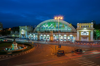
สถานีรถไฟกรุงเทพ Address: ถนนรองเมือง street in ปทุมวัน
Places Near สถานีรถไฟกรุงเทพ (ปทุมวัน)
How to get to popular places in Bangkok with public transit
Get around ปทุมวัน by public transit!
Traveling around ปทุมวัน has never been so easy. See step by step directions as you travel to any attraction, street or major public transit station. View bus and train schedules, arrival times, service alerts and detailed routes on a map, so you know exactly how to get to anywhere in ปทุมวัน.
When traveling to any destination around ปทุมวัน use Moovit's Live Directions with Get Off Notifications to know exactly where and how far to walk, how long to wait for your line, and how many stops are left. Moovit will alert you when it's time to get off — no need to constantly re-check whether yours is the next stop.
Wondering how to use public transit in ปทุมวัน or how to pay for public transit in ปทุมวัน? Moovit public transit app can help you navigate your way with public transit easily, and at minimum cost. It includes public transit fees, ticket prices, and costs. Looking for a map of ปทุมวัน public transit lines? Moovit public transit app shows all public transit maps in ปทุมวัน with all Bus, Train, Metro, SkyTrain and Ferry routes and stops on an interactive map.
Bangkok has 5 transit type(s), including: Bus, Train, Metro, SkyTrain and Ferry, operated by several transit agencies, including บีทีเอส BTS, MRT, ไทย สมายล์ บัส;Thai Smile Bus, ขสมก. BMTA, รถไฟฟ้ารฟท. SRTET, รถประจำทาง Transport Bus, บีอาร์ที BRT, เรือคลองโดยสาร Canal Ferry, เรือข้ามฟาก River Ferry, รถสองแถว Songthaew, จุฬาป๊อบบัส Chula Pop Bus, ขสมก BMTA, ขสมก. (BMTA), รถมินิบัส Minibus and รฟท. SRT