Narimasu-cho stop - Monday schedule
| Line | Direction | Time |
|---|---|---|
| Yoshi 60 | Narimasu-cho (Shakujiikoen Station) Kichijoji Station | 06:15 |
| Ren 42 | Narimasu-cho (Yagihara-ni) Nerima Station | 06:26 |
| Yoshi 60 | Narimasu-cho (Shakujiikoen Station) Kichijoji Station | 06:35 |
| Yoshi 60 | Narimasu-cho (Shakujiikoen Station) Kichijoji Station | 06:50 |
| Ren 42 | Narimasu-cho (Yagihara-ni) Nerima Station | 06:58 |
| Yoshi 60 | Narimasu-cho (Shakujiikoen Station) Kichijoji Station | 07:05 |
| Ren 42 | Narimasu-cho (Yagihara-ni) Nerima Station | 07:18 |
| Yoshi 60 | Narimasu-cho (Shakujiikoen Station) Kichijoji Station | 07:25 |
| Ren 42 | Narimasu-cho (Yagihara-ni) Nerima Station | 07:42 |
| Yoshi 60 | Narimasu-cho (Shakujiikoen Station) Kichijoji Station | 07:45 |
| Ren 42 | Narimasu-cho (Yagihara-ni) Nerima Station | 08:00 |
| Yoshi 60 | Narimasu-cho (Shakujiikoen Station) Kichijoji Station | 08:05 |
| Ren 42 | Narimasu-cho (Yagihara-ni) Nerima Station | 08:17 |
| Yoshi 60 | Narimasu-cho (Shakujiikoen Station) Kichijoji Station | 08:25 |
| Ren 42 | Narimasu-cho (Yagihara-ni) Nerima Station | 08:32 |
| Yoshi 60 | Narimasu-cho (Shakujiikoen Station) Kichijoji Station | 08:45 |
| Ren 42 | Narimasu-cho (Yagihara-ni) Nerima Station | 08:47 |
| Ren 42 | Narimasu-cho (Yagihara-ni) Nerima Station | 09:07 |
| Yoshi 60 | Narimasu-cho (Shakujiikoen Station) Kichijoji Station | 09:10 |
| Yoshi 60 | Narimasu-cho (Shakujiikoen Station) Kichijoji Station | 09:30 |
| Ren 42 | Narimasu-cho (Yagihara-ni) Nerima Station | 09:31 |
| Yoshi 60 | Narimasu-cho (Shakujiikoen Station) Kichijoji Station | 09:50 |
| Ren 42 | Narimasu-cho (Yagihara-ni) Nerima Station | 10:01 |
| Yoshi 60 | Narimasu-cho (Shakujiikoen Station) Kichijoji Station | 10:05 |
| Yoshi 60 | Narimasu-cho (Shakujiikoen Station) Kichijoji Station | 10:25 |
Directions to Narimasu-cho stop (Itabashi Ward) with public transit
The following transit lines have routes that pass near Narimasu-cho
 Bus: Mashi 14, Ren 42, Nerima High 01, Aka 02, Mashi 16.
- Train: Tojosen, Tojosen.
- Metro: Fukutoshin Line, Yurakucho Line, Fukutoshin Line, Yurakucho Line.
How to get to Narimasu-cho stop by bus?
Click on the bus route to see step by step directions with maps, line arrival times and updated time schedules.
How to get to Narimasu-cho stop by train?
Click on the train route to see step by step directions with maps, line arrival times and updated time schedules.
How to get to Narimasu-cho stop by metro?
Click on the metro route to see step by step directions with maps, line arrival times and updated time schedules.
Bus stops near Narimasu-cho stop in Itabashi Ward
- Narimasu Station Entrance, 1 min walk,
- Narimasu-cho, 1 min walk,
- Narimasu Station South Exit, 4 min walk,
Metro stations near Narimasu-cho station in Itabashi Ward
- Subway Akatsuka, 20 min walk,
Train stations near Narimasu-cho station in Itabashi Ward
- Shimo-akatsuka, 23 min walk,
Bus lines to Narimasu-cho stop in Itabashi Ward
- Mashi 16, Bikuni Bridge,
- Ishi 02, Narimasu Station South Exit,
- Ishi 03, Shakujiikoen Station North Exit,
- Izumi 33, Oizumigakuen Station North Exit ~ Narimasu Station South Exit,
- Izumi 33 Night Bus, [Late Night] Narimasu Station South Exit (Nagakubo) Oizumi,
- Izumi 34, Narimasu Station South Exit to Nagakubo,
- Ishi 02, Narimasu Station (Bikunibashi) to Shakujiikoen Station,
- Yoshi 60, Kichijoji Station (Shakujii-koen Station) Narimasu-cho,
- Zo 72, Shirako Terminal - Narimasu Town,
- Ishi 11, Seibu Depot to Narimasu Town,
- Ren 40, To Narimasu via Takamatsu-5 from Minami-Tanaka Depot,
- Ren 42, Nerima Station (Yagihara 2) Narimasu Town,
- Ko 31, Narimasu Station South Exit to Hikarigaoka Station,
- Nerima High 01, Nerima-Takanodai Station (Hikarigaoka) Narimasu Station South Exit,
- Nerima High 02, Minami-tanaka Depot (Hikarigaoka Station) Narimasu Station South Exit,
- Ren 47, Nerima Station (Shimo-Akatsuka Station) Narimasu Station South Exit,
What are the closest stations to Narimasu-cho?
The closest stations to Narimasu-cho are:
- Narimasu Station Entrance is 3 meters away, 1 min walk.
- Narimasu-cho is 6 meters away, 1 min walk.
- Narimasu Station South Exit is 291 meters away, 4 min walk.
- Subway Akatsuka is 1544 meters away, 20 min walk.
- Shimo-akatsuka is 1719 meters away, 23 min walk.
Which bus lines stop near Narimasu-cho?
These bus lines stop near Narimasu-cho: Mashi 14, Ren 42, Nerima High 01, Aka 02.
Which train line stops near Narimasu-cho?
Tojosen (Narimasu)
Which metro lines stop near Narimasu-cho?
These metro lines stop near Narimasu-cho: Fukutoshin Line, Yurakucho Line.
What’s the nearest metro station to Narimasu-cho in Itabashi Ward?
The nearest metro station to Narimasu-cho in Itabashi Ward is Subway Akatsuka. It’s a 20 min walk away.
What’s the nearest train station to Narimasu-cho in Itabashi Ward?
The nearest train station to Narimasu-cho in Itabashi Ward is Shimo-akatsuka. It’s a 23 min walk away.
What’s the nearest bus station to Narimasu-cho in Itabashi Ward?
The nearest bus stations to Narimasu-cho in Itabashi Ward are Narimasu Station Entrance and Narimasu-cho. The closest one is a 1 min walk away.
What time is the first metro to Narimasu-cho in Itabashi Ward?
The Yurakucho Line is the first metro that goes to Narimasu-cho in Itabashi Ward. It stops nearby at 5:00 AM.
What time is the last metro to Narimasu-cho in Itabashi Ward?
The Yurakucho Line is the last metro that goes to Narimasu-cho in Itabashi Ward. It stops nearby at 12:32 AM.
What time is the first train to Narimasu-cho in Itabashi Ward?
The Tojosen is the first train that goes to Narimasu-cho in Itabashi Ward. It stops nearby at 4:49 AM.
What time is the last train to Narimasu-cho in Itabashi Ward?
The Tojosen is the last train that goes to Narimasu-cho in Itabashi Ward. It stops nearby at 12:52 AM.
What time is the first bus to Narimasu-cho in Itabashi Ward?
The Ishi 03 is the first bus that goes to Narimasu-cho in Itabashi Ward. It stops nearby at 5:57 AM.
What time is the last bus to Narimasu-cho in Itabashi Ward?
The Izumi 33 Night Bus is the last bus that goes to Narimasu-cho in Itabashi Ward. It stops nearby at 11:36 PM.
See Narimasu-cho stop, Itabashi Ward, on the map
Public transit to Narimasu-cho stop in Itabashi Ward
Looking for directions to Narimasu-cho in Itabashi Ward, Japan?
Download the Moovit App to find the current schedule and step-by-step directions for Metro, Bus, Train or Light Rail routes that pass through Narimasu-cho.
Looking for the nearest stops closest to Narimasu-cho ? Check out this list of closest stops to your destination: Narimasu Station Entrance; Narimasu-cho; Narimasu Station South Exit; Subway Akatsuka; Shimo-akatsuka.
Bus: Mashi 14, Ren 42, Nerima High 01, Aka 02, Mashi 16, Ishi 02, Ishi 03, Izumi 33, Izumi 33 Night Bus, Izumi 34, Ishi 02, Yoshi 60, Zo 72, Ishi 11, Ren 40, Ren 42, Ko 31, Nerima High 01, Nerima High 02, Ren 47.Train: Tojosen, Tojosen.Metro: Fukutoshin Line, Yurakucho Line, Fukutoshin Line, Yurakucho Line.
We make riding on public transit to Narimasu-cho easy, which is why over 1.5 million users, including users in Itabashi Ward trust Moovit as the best app for public transit.
Use the app to navigate to popular places including to the airport, hospital, stadium, grocery store, mall, coffee shop, school, college, and university.
The first line to this stop is Yoshi 60, at 06:15, and the last line is Ishi 11 at 22:35.
This stop serves Seibu Bus’s lines
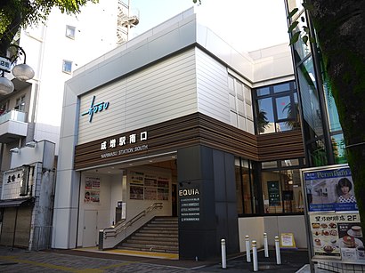
Narimasu Station (成増駅, Narimasu-eki) is a railway station on the Tobu Tojo Line in Itabashi, Tokyo, Japan, operated by the private railway operator Tobu Railway.Wiki
- Narimasu Station Entrance,
- Narimasu-cho,
- Narimasu Station South Exit
Bus stops near Narimasu-cho stop
- Subway Akatsuka
Metro station near Narimasu-cho station
- Shimo-akatsuka
Train station near Narimasu-cho station
- Someya Terminal,
- Saiwai-cho 1-chome (Kawaguchi City),
- In Front of Shiki City Martial Arts Hall,
- Minami-Urawa Station West Exit,
- Rikkyo University,
- Minami-Tagara,
- Tajima South,
- Toshima City Office,
- Tokiwadai Post Office,
- Shingashi Metropolitan Housing Entrance,
- Akabane Station West Exit,
- In front of Agricultural Cooperative (Nerima),
- Hasune 1-chome,
- Skip City East,
- Hatchobori,
- Inuma-kata,
- Industrial Road East (Adachi Shikaharama),
- Toda Station (Toda City Community Bus),
- City Hospital South,
- Kotobashi Street
Popular public transit stations in Itabashi Ward
Get around Itabashi Ward by public transit!
Traveling around Itabashi Ward has never been so easy. See step by step directions as you travel to any attraction, street or major public transit station. View bus and train schedules, arrival times, service alerts and detailed routes on a map, so you know exactly how to get to anywhere in Itabashi Ward.
When traveling to any destination around Itabashi Ward use Moovit's Live Directions with Get Off Notifications to know exactly where and how far to walk, how long to wait for your line, and how many stops are left. Moovit will alert you when it's time to get off — no need to constantly re-check whether yours is the next stop.
Wondering how to use public transit in Itabashi Ward or how to pay for public transit in Itabashi Ward? Moovit public transit app can help you navigate your way with public transit easily, and at minimum cost. It includes public transit fees, ticket prices, and costs. Looking for a map of Itabashi Ward public transit lines? Moovit public transit app shows all public transit maps in Itabashi Ward with all Bus, Train, Metro and Light Rail routes and stops on an interactive map.
Tokyo has 4 transit type(s), including: Bus, Train, Metro and Light Rail, operated by several transit agencies, including JR East, Sagami Railway, Toei Bus, Kokusai Kogyo Bus, Machida City Community, Tokyo Metro, Hamura City (Hamuran), Keisei Transit Bus Co., Ltd., Tokyo Metropolitan Transportation Bureau, Hachioji City (Hachi Bus), Hinode Town (Gurulin Hinode-chan), Hitachi Motor Transportation Co., Ltd., Tokyu Bus, Seibu Bus and Akiruno City (Runo Bus)