Directions to 沙田蘇浙公學 (沙田 Sha Tin) with public transportation
The following transit lines have routes that pass near 沙田蘇浙公學
 Bus: 280X, 40X, 48X, 60K, 62K.
- Subway: 東鐵綫 EAST RAIL LINE, 屯馬綫 TUEN MA LINE.
How to get to 沙田蘇浙公學 by bus?
Click on the bus route to see step by step directions with maps, line arrival times and updated time schedules.
How to get to 沙田蘇浙公學 by subway?
Click on the subway route to see step by step directions with maps, line arrival times and updated time schedules.
Bus stops near 沙田蘇浙公學 in 沙田 Sha Tin
- 德厚街, 禾輋商場外 Tak Hau Street, Outside Wo Che Commercial Centre, 1 min walk,
- 禾輋巴士總站 Wo Che B/T, 3 min walk,
- 禾輋邨 Wo Che Estate, 3 min walk,
- 德厚街, 禾輋邨德和樓外 Tak Hau Street, Outside Tak Wo House, Wo Che Estate, 3 min walk,
- 源禾路,近沙田運動場 Yuen Wo Road, Ear Sha Tin Sports Ground, 3 min walk,
- 源禾路, 近沙田運動場 Yuen Wo Road, Near Sha Tin Sports Ground, 3 min walk,
- 源禾路,近禾輋邨協和樓 Yuen Wo Road, Near Hip Wo House, Wo Che Estate, 4 min walk,
- 祿泉樓 Luk Chuen House, 5 min walk,
Subway stations near 沙田蘇浙公學 in 沙田 Sha Tin
- 沙田圍 Sha Tin Wai, 4 min walk,
- 火炭 Fo Tan, 14 min walk,
Bus lines to 沙田蘇浙公學 in 沙田 Sha Tin
- 60C, 火炭平房區 Fo Tan Cottage Area,
- 60K, 黃竹洋村 Wong Chuk Yeung Village,
- 62K, 樂楓徑, 景峰閣外 LOK Fung Path, Outside Mountainbille Court,
- 48X, 禾輋 Wo Che - 荃灣(灣景花園) Tsuen Wan (Bayview Garden),
- 81, 禾輋 Wo Che - 佐敦(西九龍站) Jordan (West Kowloon Station),
- 83P, 黃泥頭 Wong Nai Tau - 禾輋 Wo Che,
- NA40, 機場 / 港珠澳大橋香港口岸 Airport / HZMB Hong Kong Port - 烏溪沙站 Wu Kai Sha Station,
- 40X, 烏溪沙站 Wu Kai Sha Station - 葵涌邨 Kwai Chung Estate,
- E42P, 東涌(逸東邨) Tung Chung (Yat Tung Estate) - 火炭(山尾街) Fo Tan (Shan Mei Street),
- A46, 火炭(駿景園) Fo Tan (Royal Ascot) - 機場 Airport,
- 48P, 青龍頭 Tsing Lung Tau - 火炭(駿洋邨) Fo Tan (Chun Yeung Estate),
- 72, 大埔(太和) Tai Po (Tai Wo) - 長沙灣 Cheung Sha Wan,
- 72A, 大圍站 Tai Wai Station - 大埔工業邨 Tai Po Industrial Estate,
- N73, 沙田市中心 Sha Tin Central - 落馬洲 Lok Ma Chau,
- 79, 粉嶺(皇后山) Fanling (Queen’s Hill) - 大圍站 Tai Wai Station,
- 80K, 新翠 Sun Chui - 愉翠苑 Yu Chui Court,
- 81K, 新田圍 Sun Tin Wai - 穗禾苑 Sui Wo Court,
- 83K, 黃泥頭 Wong Nai Tau - 沙田市中心(循環線) Sha Tin Central (Circular),
- 85, 火炭(駿洋邨) Fo Tan (Chun Yeung Estate) - 九龍城碼頭 Kowloon City Ferry,
- 85K, 恆安 Heng On - 沙田站 Sha Tin Station,
What are the closest stations to 沙田蘇浙公學?
The closest stations to 沙田蘇浙公學 are:
- 德厚街, 禾輋商場外 Tak Hau Street, Outside Wo Che Commercial Centre is 44 meters away, 1 min walk.
- 禾輋巴士總站 Wo Che B/T is 154 meters away, 3 min walk.
- 禾輋邨 Wo Che Estate is 170 meters away, 3 min walk.
- 德厚街, 禾輋邨德和樓外 Tak Hau Street, Outside Tak Wo House, Wo Che Estate is 206 meters away, 3 min walk.
- 源禾路,近沙田運動場 Yuen Wo Road, Ear Sha Tin Sports Ground is 207 meters away, 3 min walk.
- 源禾路, 近沙田運動場 Yuen Wo Road, Near Sha Tin Sports Ground is 220 meters away, 3 min walk.
- 源禾路,近禾輋邨協和樓 Yuen Wo Road, Near Hip Wo House, Wo Che Estate is 245 meters away, 4 min walk.
- 沙田圍 Sha Tin Wai is 262 meters away, 4 min walk.
- 祿泉樓 Luk Chuen House is 376 meters away, 5 min walk.
- 火炭 Fo Tan is 1093 meters away, 14 min walk.
Which bus lines stop near 沙田蘇浙公學?
These bus lines stop near 沙田蘇浙公學: 280X, 40X, 48X, 60K, 62K, 798, 85.
Which subway line stops near 沙田蘇浙公學?
東鐵綫 EAST RAIL LINE (往羅湖 To Lo Wu)
What’s the nearest subway station to 沙田蘇浙公學 in 沙田 Sha Tin?
The nearest subway station to 沙田蘇浙公學 in 沙田 Sha Tin is 沙田圍 Sha Tin Wai. It’s a 4 min walk away.
What’s the nearest bus station to 沙田蘇浙公學 in 沙田 Sha Tin?
The nearest bus station to 沙田蘇浙公學 in 沙田 Sha Tin is 德厚街, 禾輋商場外 Tak Hau Street, Outside Wo Che Commercial Centre. It’s a 1 min walk away.
What time is the first subway to 沙田蘇浙公學 in 沙田 Sha Tin?
The 東鐵綫 EAST RAIL LINE is the first subway that goes to 沙田蘇浙公學 in 沙田 Sha Tin. It stops nearby at 5:35 AM.
What time is the last subway to 沙田蘇浙公學 in 沙田 Sha Tin?
The 東鐵綫 EAST RAIL LINE is the last subway that goes to 沙田蘇浙公學 in 沙田 Sha Tin. It stops nearby at 1:19 AM.
What time is the first bus to 沙田蘇浙公學 in 沙田 Sha Tin?
The 61S is the first bus that goes to 沙田蘇浙公學 in 沙田 Sha Tin. It stops nearby at 3:00 AM.
What time is the last bus to 沙田蘇浙公學 in 沙田 Sha Tin?
The N73 is the last bus that goes to 沙田蘇浙公學 in 沙田 Sha Tin. It stops nearby at 3:35 AM.
See 沙田蘇浙公學, 沙田 Sha Tin, on the map
Public Transit to 沙田蘇浙公學 in 沙田 Sha Tin
Wondering how to get to 沙田蘇浙公學 in 沙田 Sha Tin? Moovit helps you find the best way to get to 沙田蘇浙公學 with step-by-step directions from the nearest public transit station.
Moovit provides free maps and live directions to help you navigate through your city. View schedules, routes, timetables, and find out how long does it take to get to 沙田蘇浙公學 in real time.
Looking for the nearest stop or station to 沙田蘇浙公學? Check out this list of stops closest to your destination: 德厚街; 禾輋巴士總站 Wo Che B/T; 禾輋邨 Wo Che Estate; 德厚街; 源禾路,近沙田運動場 Yuen Wo Road; 源禾路; 源禾路,近禾輋邨協和樓 Yuen Wo Road; 沙田圍 Sha Tin Wai; 祿泉樓 Luk Chuen House; 火炭 Fo Tan.
Bus: 280X, 40X, 48X, 60K, 62K, 798, 85, 60C, 81, 83P, NA40, E42P, A46, 48P, 987.Subway: 東鐵綫 EAST RAIL LINE, 屯馬綫 TUEN MA LINE.
Want to see if there’s another route that gets you there at an earlier time? Moovit helps you find alternative routes or times. Get directions from and directions to 沙田蘇浙公學 easily from the Moovit App or Website.
We make riding to 沙田蘇浙公學 easy, which is why over 1.5 million users, including users in 沙田 Sha Tin, trust Moovit as the best app for public transit. You don’t need to download an individual bus app or train app, Moovit is your all-in-one transit app that helps you find the best bus time or train time available.
For information on prices of bus and subway, costs and ride fares to 沙田蘇浙公學, please check the Moovit app.
Use the app to navigate to popular places including to the airport, hospital, stadium, grocery store, mall, coffee shop, school, college, and university.
沙田蘇浙公學 Address: 豐順街 7 沙田区, 新界 street in 沙田 Sha Tin
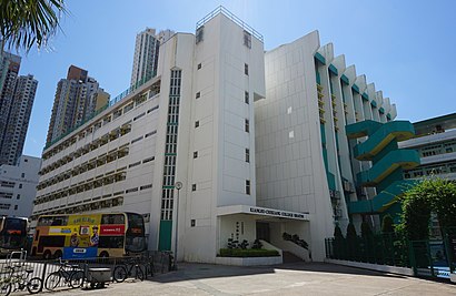
Kiangsu-Chekiang College (Shatin) (Chinese: 沙田蘇浙公學), abbreviated as KCCS or KCCST, is one of the secondary schools in Sha Tin District, Hong Kong. The school campus is next to Shatin Pui Ying College.Wiki
- Footspot.,
- KFC,
- 禾輋巴士总站,
- Wo Che Bus Terminus 禾輋巴士總站,
- Kiangsu-Chekiang College (Shatin) 沙田蘇浙公學,
- 沙田培英中學,
- 沙田培英中學 Shatin Pui Ying College,
- Shatin Pui Ying College 沙田培英中學,
- 禾輋社區會堂 Wo Che Community Hall,
- 魚陣營,
- 禾輋邨厚和樓,
- 沙田蘇浙公學 Kiangsu-Chekiang College (Sha Tin),
- Classic in Shun Tak (順德經典),
- Wo Che Plaza (禾輋廣場),
- 陳根記,
- QB House,
- 味之誘惑,
- 禾輋邨-禾輋廣場,
- 禾輋社區會堂,
- 禾輋村
Places Near 沙田蘇浙公學 (沙田 Sha Tin)
- 沙田馬場 Sha Tin Racecourse, 沙田 Sha Tin,
- 威爾斯親王醫院, 沙田 Sha Tin,
- 富麗敦海洋公園酒店 the Fullerton Hotel: Ocean Park,
- 天水圍(天業路)社區健康中心 Tin Shui Wai (Tin Yip Road) Community Health Centre, 元朗 Yuen Long,
- 大埔海濱公園, 大埔 Tai Po,
- China Travel Service Tuen Mun Entry Permit Service Centre 中國旅行社屯門證件服務中心, 屯門 Tuen Mun,
- 香港東涌福朋喜來登酒店,
- 香港教育大學, 大埔 Tai Po,
- 入境事務處人事登記處辦事處, 觀塘 Kwun Tong,
- 啟德體育園 Kai Tak Sports Park, 九龍 Kowloon City,
- 林村許願樹, 大埔 Tai Po,
- 宏利金融中心 Manulife Financial Centre, 觀塘 Kwun Tong,
- Airside, 九龍 Kowloon City,
- 九龍灣健康中心 Kowloon Bay Health Centre, 觀塘 Kwun Tong,
- 香港駕駛學院沙田安全駕駛中心, 沙田 Sha Tin,
- 屯門兆麟政府綜合大樓 Tuen Mun Siu Lun Government Complex, 屯門 Tuen Mun,
- 大欖涌燒烤樂園 Tai Lam Chung Bbq Club, 屯門 Tuen Mun,
- 中港城,
- Shatin Hospital 沙田醫院, 沙田 Sha Tin,
- 麗豪酒店, 沙田 Sha Tin
How to get to popular places in Hong Kong with public transit
Get around 沙田 Sha Tin by public transit!
Traveling around 沙田 Sha Tin has never been so easy. See step by step directions as you travel to any attraction, street or major public transit station. View bus and train schedules, arrival times, service alerts and detailed routes on a map, so you know exactly how to get to anywhere in 沙田 Sha Tin.
When traveling to any destination around 沙田 Sha Tin use Moovit's Live Directions with Get Off Notifications to know exactly where and how far to walk, how long to wait for your line, and how many stops are left. Moovit will alert you when it's time to get off — no need to constantly re-check whether yours is the next stop.
Wondering how to use public transit in 沙田 Sha Tin or how to pay for public transit in 沙田 Sha Tin? Moovit public transit app can help you navigate your way with public transit easily, and at minimum cost. It includes public transit fees, ticket prices, and costs. Looking for a map of 沙田 Sha Tin public transit lines? Moovit public transit app shows all public transit maps in 沙田 Sha Tin with all Bus, Subway, Light Rail, Ferry, Cable Car and Funicular routes and stops on an interactive map.
Hong Kong has 6 transit type(s), including: Bus, Subway, Light Rail, Ferry, Cable Car and Funicular, operated by several transit agencies, including 港鐵 MTR, 天星小輪 Star Ferry, 九巴 KMB, 城巴 Citybus, 城巴機場快線 Cityflyer, 龍運巴士 LWB, 九巴 KMB / 城巴 CTB, 龍運巴士 LWB / 城巴 CTB, 新大嶼山巴士 NLB, 愉景灣巴士 DB, 香港電車 Hong Kong Tramways, 香港中文大學 The Chinese University of Hong Kong, 港島區專線小巴 GMB HK Island, 九龍區專線小巴 GMB Kowloon and 新界區專線小巴 GMB New Territories