琴行街 Kam Hong Street stop - Thursday schedule
| Line | Direction | Time |
|---|---|---|
| N8X | 小西灣(藍灣半島) Siu Sai Wan (Island Resort) | 03:07 |
| N72 | 鰂魚涌(海澤街) Quarry Bay (Hoi Chak Street) | 03:29 |
| N8X | 小西灣(藍灣半島) Siu Sai Wan (Island Resort) | 03:37 |
| N72 | 鰂魚涌(海澤街) Quarry Bay (Hoi Chak Street) | 03:59 |
| N8X | 小西灣(藍灣半島) Siu Sai Wan (Island Resort) | 04:07 |
| N72 | 鰂魚涌(海澤街) Quarry Bay (Hoi Chak Street) | 04:29 |
| N8X | 小西灣(藍灣半島) Siu Sai Wan (Island Resort) | 04:37 |
| N72 | 鰂魚涌(海澤街) Quarry Bay (Hoi Chak Street) | 04:59 |
| N8X | 小西灣(藍灣半島) Siu Sai Wan (Island Resort) | 05:07 |
| N72 | 鰂魚涌(海澤街) Quarry Bay (Hoi Chak Street) | 05:29 |
| N8X | 小西灣(藍灣半島) Siu Sai Wan (Island Resort) | 05:37 |
| N8X | 小西灣(藍灣半島) Siu Sai Wan (Island Resort) | 06:07 |
| 81 | 興華邨 Hing Wah Estate | 06:15 |
| 99 | 筲箕灣 Shau Kei Wan | 06:15 |
| 8X | 小西灣(藍灣半島) Siu Sai Wan (Island Resort) | 06:29 |
| 77 | 筲箕灣 Shau Kei Wan | 06:31 |
| 81 | 興華邨 Hing Wah Estate | 06:35 |
| 99 | 筲箕灣 Shau Kei Wan | 06:35 |
| 2A | 耀東邨 Yiu Tung Estate | 06:36 |
| 18P | 北角(健康中街) North Point (Healthy Street Central) | 06:39 |
| 觀塘(宜安街) — 西貢市中心 | 觀塘(宜安街) Kwun Tong (Yee on St) | 06:40 |
| 8X | 小西灣(藍灣半島) Siu Sai Wan (Island Resort) | 06:45 |
| 77 | 筲箕灣 Shau Kei Wan | 06:51 |
| 觀塘(宜安街) — 西貢市中心 | 觀塘(宜安街) Kwun Tong (Yee on St) | 06:52 |
| 81 | 興華邨 Hing Wah Estate | 06:55 |
Directions to 琴行街 Kam Hong Street stop (東區 Eastern) with public transit
The following transit lines have routes that pass near 琴行街 Kam Hong Street
 Bus: 102, 33X, 619, 680, 690.
- Subway: 將軍澳綫 TSEUNG KWAN O LINE, 港島綫 ISLAND LINE.
How to get to 琴行街 Kam Hong Street stop by bus?
Click on the bus route to see step by step directions with maps, line arrival times and updated time schedules.
How to get to 琴行街 Kam Hong Street stop by subway?
Click on the subway route to see step by step directions with maps, line arrival times and updated time schedules.
Light Rail stations near 琴行街 Kam Hong Street station in 東區 Eastern
- 書局街 Shu Kuk Street, 2 min walk,
Subway stations near 琴行街 Kam Hong Street station in 東區 Eastern
- 北角 North Point, 2 min walk,
Bus stops near 琴行街 Kam Hong Street stop in 東區 Eastern
- 馬寶道, 華禮大廈外 Marble Road, Outside Wah Lai Mansion, 2 min walk,
- 馬寶道 Marble Road, 2 min walk,
- 港運城 Island Place, 2 min walk,
- 英皇道,近港運城 King's Road, Near Island Place, 2 min walk,
- 英皇道, 近港鐵北角站 King's Road, Near North Point Mtr Station, 2 min walk,
- 英皇道, 港運城 Island Place, King's Road, 3 min walk,
- 琴行街 Kam Hong Street, 3 min walk,
- 渣華道市政大廈 Java Road Complex, 4 min walk,
Bus lines to 琴行街 Kam Hong Street stop in 東區 Eastern
- 33, 馬寶道, 華禮大廈外 Marble Road, Outside Wah Lai Mansion,
- 56, 羅便臣道, 秀麗閣對面 Robinson Road, Opposite Serene Court,
- 10, 堅尼地城 Kennedy Town - 北角碼頭 North Point Ferry Pier,
- 23, 北角碼頭 North Point Ferry Pier - 蒲飛路 Pokfield Road,
- 27, 北角碼頭 North Point Ferry Pier - 寶馬山(循環線) Braemar Hill (Circular),
- 38, 置富花園 Chi Fu Fa Yuen - 北角碼頭 North Point Ferry Pier,
- 42, 華富(南) Wah Fu (South) - 北角碼頭 North Point Ferry Pier,
- 42C, 數碼港 Cyberport - 北角碼頭 North Point Ferry Pier,
- 63, 北角碼頭 North Point Ferry Pier - 赤柱村 Stanley Village,
- 65, 北角碼頭 North Point Ferry Pier - 赤柱市場 Stanley Market,
- 82, 小西灣(藍灣半島) Siu Sai Wan (Island Resort) - 北角碼頭 North Point Ferry Pier,
- 85, 小西灣(藍灣半島) Siu Sai Wan (Island Resort) - 寶馬山 / 北角碼頭 Braemar Hill / North Point Ferry Pier,
- 觀塘(宜安街) — 西貢市中心, Kwun Tong (Yee On St) - Sai Kung Town Centre,
- 2, 西灣河(嘉亨灣) Sai Wan Ho (Grand Promenade) - 中環(港澳碼頭) Central (Macau Ferry),
- 2A, 耀東邨 Yiu Tung Estate - 會展站 Exhibition Centre Station,
- 8H, 小西灣 (藍灣半島) Siu Sai Wan (Island Resort) - 東華東院 Tung Wah Eastern Hospital,
- N8X, 小西灣(藍灣半島) Siu Sai Wan (Island Resort) - 堅尼地城 Kennedy Town,
- 8X, 小西灣(藍灣半島) Siu Sai Wan (Island Resort) - 跑馬地上(大坑道) Happy Valley (Upper) (Tai Hang Road),
- 18, 北角(健康中街) North Point (Healthy Street Central) - 堅尼地城(卑路乍灣) Kennedy Town (Belcher Bay),
- 18P, 堅尼地城(卑路乍灣) Kennedy Town (Belcher Bay) - 北角(健康中街) North Point (Healthy Street Central),
What are the closest stations to 琴行街 Kam Hong Street?
The closest stations to 琴行街 Kam Hong Street are:
- 書局街 Shu Kuk Street is 91 meters away, 2 min walk.
- 北角 North Point is 109 meters away, 2 min walk.
- 馬寶道, 華禮大廈外 Marble Road, Outside Wah Lai Mansion is 117 meters away, 2 min walk.
- 馬寶道 Marble Road is 131 meters away, 2 min walk.
- 港運城 Island Place is 133 meters away, 2 min walk.
- 英皇道,近港運城 King's Road, Near Island Place is 139 meters away, 2 min walk.
- 英皇道, 近港鐵北角站 King's Road, Near North Point Mtr Station is 142 meters away, 2 min walk.
- 英皇道, 港運城 Island Place, King's Road is 158 meters away, 3 min walk.
- 琴行街 Kam Hong Street is 221 meters away, 3 min walk.
- 渣華道市政大廈 Java Road Complex is 252 meters away, 4 min walk.
Which bus lines stop near 琴行街 Kam Hong Street?
These bus lines stop near 琴行街 Kam Hong Street: 102, 33X, 619, 680, 690, 989, 99, A12.
Which subway lines stop near 琴行街 Kam Hong Street?
These subway lines stop near 琴行街 Kam Hong Street: 將軍澳綫 TSEUNG KWAN O LINE, 港島綫 ISLAND LINE.
What’s the nearest light rail station to 琴行街 Kam Hong Street in 東區 Eastern?
The nearest light rail station to 琴行街 Kam Hong Street in 東區 Eastern is 書局街 Shu Kuk Street. It’s a 2 min walk away.
What’s the nearest subway station to 琴行街 Kam Hong Street in 東區 Eastern?
The nearest subway station to 琴行街 Kam Hong Street in 東區 Eastern is 北角 North Point. It’s a 2 min walk away.
What’s the nearest bus station to 琴行街 Kam Hong Street in 東區 Eastern?
The nearest bus stations to 琴行街 Kam Hong Street in 東區 Eastern are 馬寶道, 華禮大廈外 Marble Road, Outside Wah Lai Mansion, 馬寶道 Marble Road, 港運城 Island Place, 英皇道,近港運城 King's Road, Near Island Place and 英皇道, 近港鐵北角站 King's Road, Near North Point Mtr Station. The closest one is a 2 min walk away.
What time is the first light rail to 琴行街 Kam Hong Street in 東區 Eastern?
The 上環(西港城) - 筲箕灣 is the first light rail that goes to 琴行街 Kam Hong Street in 東區 Eastern. It stops nearby at 6:04 AM.
What time is the last light rail to 琴行街 Kam Hong Street in 東區 Eastern?
The 堅尼地城 - 筲箕灣 is the last light rail that goes to 琴行街 Kam Hong Street in 東區 Eastern. It stops nearby at 1:13 AM.
What time is the first subway to 琴行街 Kam Hong Street in 東區 Eastern?
The 港島綫 ISLAND LINE is the first subway that goes to 琴行街 Kam Hong Street in 東區 Eastern. It stops nearby at 6:07 AM.
What time is the last subway to 琴行街 Kam Hong Street in 東區 Eastern?
The 將軍澳綫 TSEUNG KWAN O LINE is the last subway that goes to 琴行街 Kam Hong Street in 東區 Eastern. It stops nearby at 1:10 AM.
What time is the first bus to 琴行街 Kam Hong Street in 東區 Eastern?
The N72 is the first bus that goes to 琴行街 Kam Hong Street in 東區 Eastern. It stops nearby at 3:01 AM.
What time is the last bus to 琴行街 Kam Hong Street in 東區 Eastern?
The N680 is the last bus that goes to 琴行街 Kam Hong Street in 東區 Eastern. It stops nearby at 3:36 AM.
琴行街 Kam Hong Street station
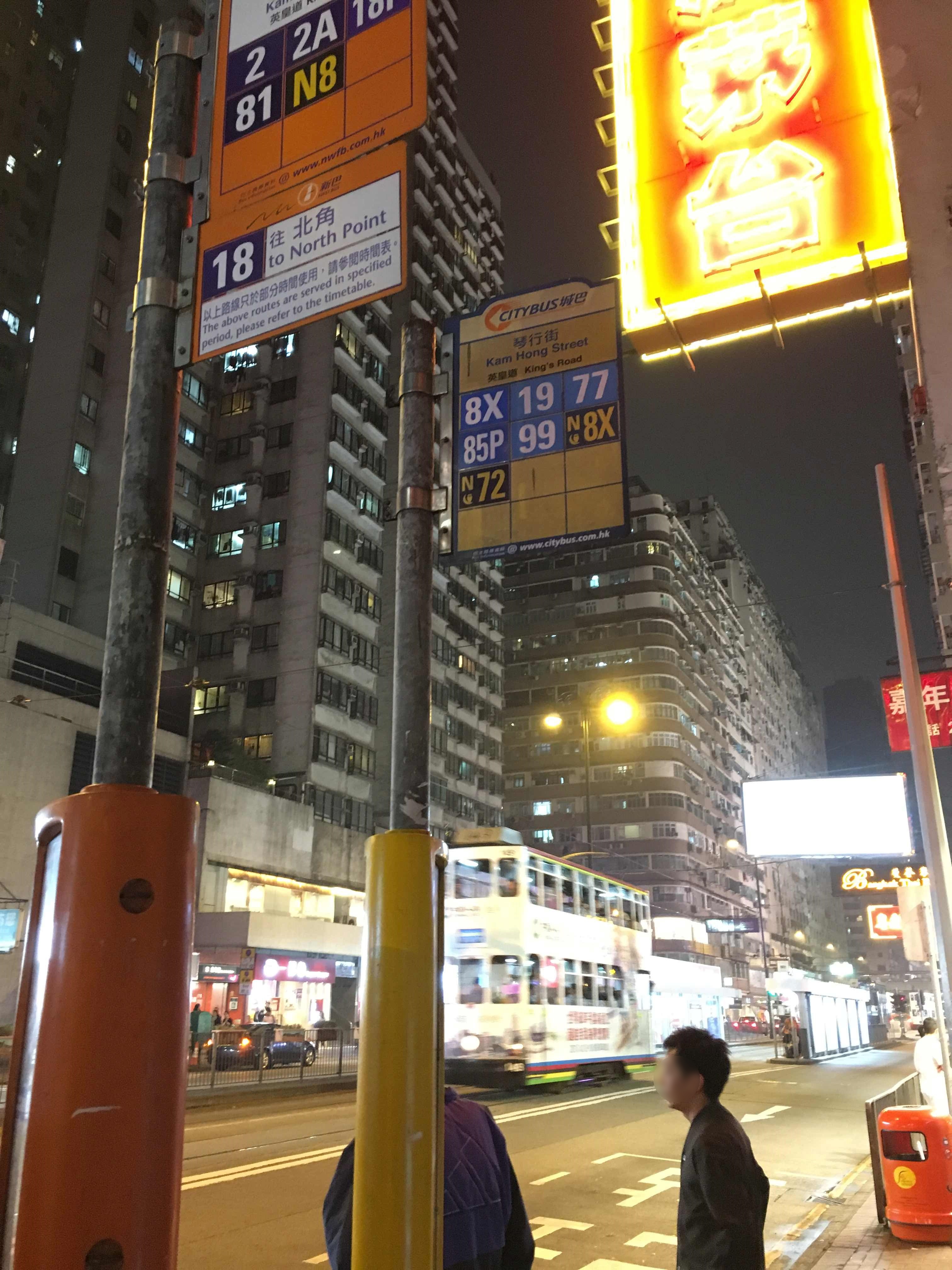 Taken by Frankie L.
See 琴行街 Kam Hong Street stop, 東區 Eastern, on the map
Public transit to 琴行街 Kam Hong Street stop (ID: 001373) in 東區 Eastern
Looking for directions to 琴行街 Kam Hong Street in 東區 Eastern, Hong Kong?
Download the Moovit App to find the current schedule and step-by-step directions for Bus or Subway routes that pass through 琴行街 Kam Hong Street.
Looking for the nearest stops closest to 琴行街 Kam Hong Street ? Check out this list of closest stops to your destination: 書局街 Shu Kuk Street; 北角 North Point; 馬寶道; 馬寶道 Marble Road; 港運城 Island Place; 英皇道,近港運城 King's Road; 英皇道; 英皇道; 琴行街 Kam Hong Street; 渣華道市政大廈 Java Road Complex.
Bus: 102, 33X, 619, 680, 690, 989, 99, A12, 33, 56, 10, 23, 27, 38, 42, 觀塘(宜安街) — 西貢市中心, 2, 2A, 8H, N8X, 65X, 65.Subway: 將軍澳綫 TSEUNG KWAN O LINE, 港島綫 ISLAND LINE.
We make riding on public transit to 琴行街 Kam Hong Street easy, which is why over 1.5 million users, including users in 東區 Eastern trust Moovit as the best app for public transit.
Use the app to navigate to popular places including to the airport, hospital, stadium, grocery store, mall, coffee shop, school, college, and university.
琴行街 Kam Hong Street stop’s code is 001373
The first line to this stop is N8X, at 03:07, and the last line is N72 at 02:59.
457-459 英皇道 King's Road, Hong Kong S.A.R.
This stop serves Citybus and Red Light Bus’s lines
- 書局街 Shu Kuk Street
Light Rail station near 琴行街 Kam Hong Street station
- 北角 North Point
Subway station near 琴行街 Kam Hong Street station
- 馬寶道, 華禮大廈外 Marble Road, Outside Wah Lai Mansion,
- 馬寶道 Marble Road,
- 港運城 Island Place,
- 英皇道,近港運城 King's Road, Near Island Place,
- 英皇道, 近港鐵北角站 King's Road, Near North Point Mtr Station,
- 英皇道, 港運城 Island Place, King's Road,
- 琴行街 Kam Hong Street,
- 渣華道市政大廈 Java Road Complex
Bus stops near 琴行街 Kam Hong Street stop
- 航天城交匯處 Sky City Interchange,
- 錦龍苑 Kam Lung Court,
- 耀中幼教學院 Yew Chung College Of Early Childhood Education,
- 嘉輝台 Greenfield Terrace,
- 荃灣聯仁街 Luen Yan Street Tsuen Wan,
- 啟田商場 Kai Tin Shopping Centre,
- 大潭郊野公園 Tai Tam Country Park,
- 興發街 Hing Fat Street,
- 南山邨南泰樓 Nam Tai House Nam Shan Estate,
- 元朗(西)總站 Yuen Long (West) B/T,
- 富榮花園 Charming Garden,
- 仁愛堂街 Kindly Hall Street,
- 竹園邨總站 Chuk Yuen Estate B/T,
- 元朗游泳池 Yuen Long Swimming Pool,
- 新慶村 San Hing Tsuen,
- 書局街 Shu Kuk Street,
- 長康邨 Cheung Hong Estate,
- 映灣園二期 Caribbean Coast Phase 2,
- 佐敦吳松街 Woosung Street Jordan,
- 西摩道 Seymour Road
Popular public transit stations in 東區 Eastern
Get around 東區 Eastern by public transit!
Traveling around 東區 Eastern has never been so easy. See step by step directions as you travel to any attraction, street or major public transit station. View bus and train schedules, arrival times, service alerts and detailed routes on a map, so you know exactly how to get to anywhere in 東區 Eastern.
When traveling to any destination around 東區 Eastern use Moovit's Live Directions with Get Off Notifications to know exactly where and how far to walk, how long to wait for your line, and how many stops are left. Moovit will alert you when it's time to get off — no need to constantly re-check whether yours is the next stop.
Wondering how to use public transit in 東區 Eastern or how to pay for public transit in 東區 Eastern? Moovit public transit app can help you navigate your way with public transit easily, and at minimum cost. It includes public transit fees, ticket prices, and costs. Looking for a map of 東區 Eastern public transit lines? Moovit public transit app shows all public transit maps in 東區 Eastern with all Bus, Subway, Light Rail, Ferry, Cable Car and Funicular routes and stops on an interactive map.
Hong Kong has 6 transit type(s), including: Bus, Subway, Light Rail, Ferry, Cable Car and Funicular, operated by several transit agencies, including 港鐵 MTR, 天星小輪 Star Ferry, 九巴 KMB, 城巴 Citybus, 城巴機場快線 Cityflyer, 龍運巴士 LWB, 九巴 KMB / 城巴 CTB, 龍運巴士 LWB / 城巴 CTB, 新大嶼山巴士 NLB, 愉景灣巴士 DB, 香港電車 Hong Kong Tramways, 香港中文大學 The Chinese University of Hong Kong, 港島區專線小巴 GMB HK Island, 九龍區專線小巴 GMB Kowloon and 新界區專線小巴 GMB New Territories