3arena stop - Sunday schedule
| Line | Direction | Time |
|---|---|---|
| 109A | Kells | 3:43 AM |
| 109A | Kells | 4:43 AM |
| 736 | Dublin Airport | 5:25 AM |
| 109A | Kells | 5:43 AM |
| 100X | Dundalk | 5:56 AM |
| 736 | Airport Zone 16 | 6:00 AM |
| 736 | Airport Zone 16 | 6:50 AM |
| 735 | Airport Zone 16 | 6:55 AM |
| 735 | Dublin Airport | 6:55 AM |
| 100X | Dundalk | 6:56 AM |
| 736 | Dublin Airport | 7:35 AM |
| 735 | Dublin Airport | 7:35 AM |
| 735 | Airport Zone 16 | 7:35 AM |
| 100X | Dundalk | 7:57 AM |
| 736 | Dublin Airport | 8:20 AM |
| 736 | Airport Zone 16 | 8:35 AM |
| 100X | Dundalk | 8:58 AM |
| 736 | Dublin Airport | 9:05 AM |
| 736 | Airport Zone 16 | 9:35 AM |
| 736 | Dublin Airport | 9:40 AM |
| 100X | Dundalk | 9:58 AM |
| 735 | Airport Zone 16 | 10:30 AM |
| 735 | Dublin Airport | 10:30 AM |
| 736 | Airport Zone 16 | 10:35 AM |
| 100X | Dundalk | 10:58 AM |
Directions to 3arena stop (Dublin) with public transit
The following transit lines have routes that pass near 3arena
 Bus: 151, 500, G1, N4, 912.
- Train: DART, RAIL.
- Light Rail: RED.
How to get to 3arena stop by bus?
Click on the bus route to see step by step directions with maps, line arrival times and updated time schedules.
How to get to 3arena stop by train?
Click on the train route to see step by step directions with maps, line arrival times and updated time schedules.
Bus stops near 3arena stop in Dublin
- Sheriff St Upr, 6 min walk,
- New Wapping Street, 6 min walk,
- East Wall, East Wall Road, 6 min walk,
- Spencer Place, 6 min walk,
- North Wall Quay, 7 min walk,
- N Wall Quay, 7 min walk,
- The Point, 7 min walk,
- East Wall Rd, 8 min walk,
Train stations near 3arena station in Dublin
- Docklands, 14 min walk,
Light Rail stations near 3arena station in Dublin
- Spencer Dock, 15 min walk,
Bus lines to 3arena stop in Dublin
- 912, The Point,
- G1, Red Cow Luas,
- G2, Liffey Valley Sc,
- N4, Point Village,
- DUBLIN AIRPORT - CHARLESLAND ROAD (SEABORNE VIEW APTS), Charlesland, Stop 7462,
- DUBLIN AIRPORT - KILLINEY (FITZPATRICK CASTLE HOTEL), Fitzpatrick Castle Hotel,
- 191, Eden Quay,
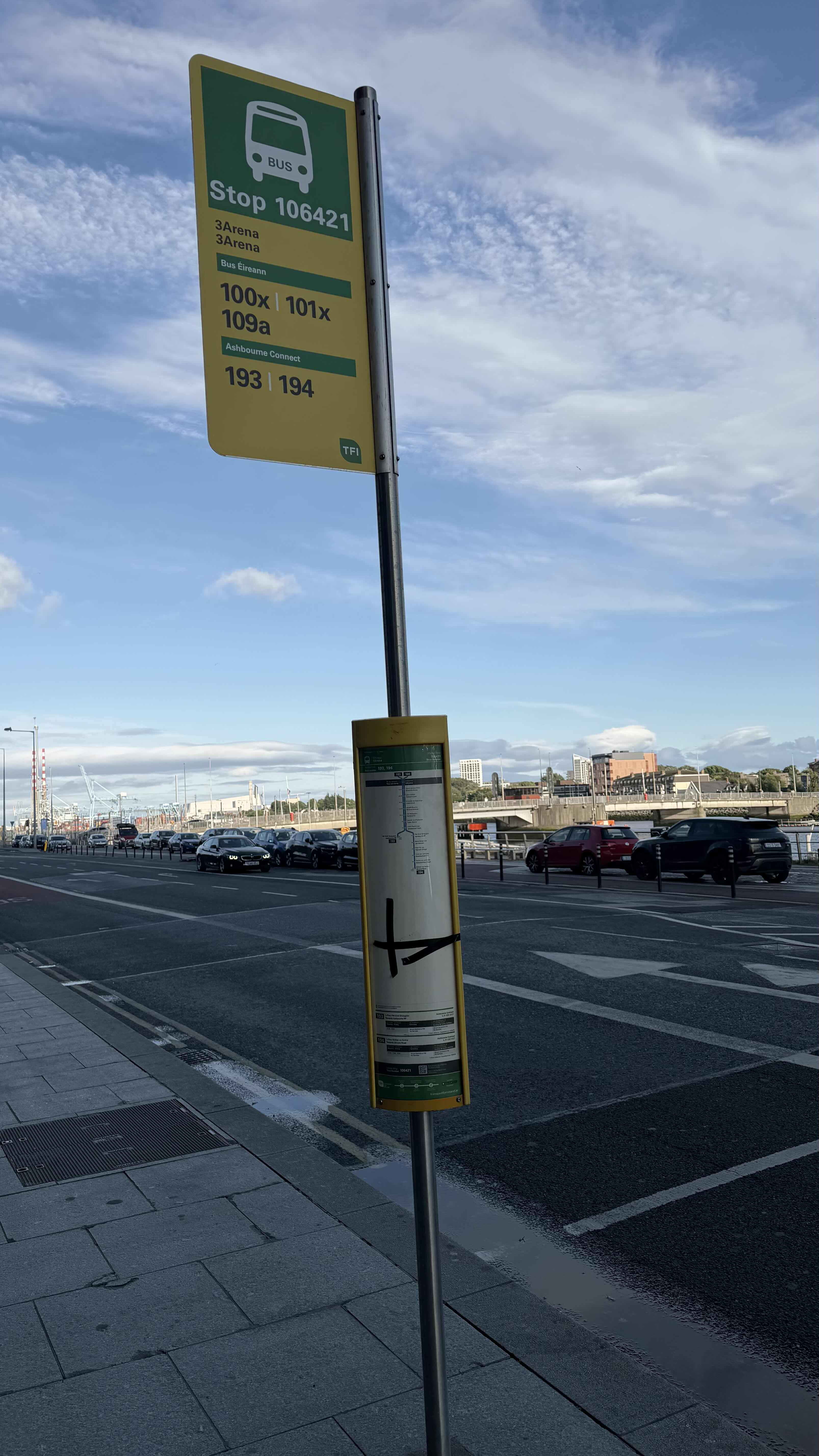
- 193, Ashbourne Rp,
- 194, Skryne Road,
- 33D, Portrane,
- 33X, Balbriggan,
- 41X, Swords Manor,
- 142, Ucd,
- 151, Docklands,
- 910, Southgate Sc,
- 100X, Dundalk,
- 500, Eden Quay,
- 500N, Ormond Avenue,
- 500X, Ormond Avenue,
- 501, Eden Quay,
What are the closest stations to 3arena?
The closest stations to 3arena are:
- Sheriff St Upr stop is 406 meters away, 6 min walk.
- New Wapping Street stop is 454 meters away, 6 min walk.
- East Wall, East Wall Road stop is 455 meters away, 6 min walk.
- Spencer Place stop is 458 meters away, 6 min walk.
- North Wall Quay stop is 469 meters away, 7 min walk.
- N Wall Quay stop is 498 meters away, 7 min walk.
- The Point stop is 499 meters away, 7 min walk.
- East Wall Rd stop is 580 meters away, 8 min walk.
- Docklands station is 1081 meters away, 14 min walk.
- Spencer Dock is 1183 meters away, 15 min walk.
Which bus lines stop near 3arena?
These bus lines stop near 3arena: 151, 500, G1, N4.
Which train lines stop near 3arena?
These train lines stop near 3arena: DART, RAIL.
Which light rail line stops near 3arena?
RED (Tallaght→The Point)
What’s the nearest light rail station to 3arena in Dublin?
The nearest light rail station to 3arena in Dublin is Spencer Dock. It’s a 15 min walk away.
What’s the nearest train station to 3arena in Dublin?
The nearest train station to 3arena in Dublin is Docklands. It’s a 14 min walk away.
What’s the nearest bus station to 3arena in Dublin?
The nearest bus stations to 3arena in Dublin are Sheriff St Upr, New Wapping Street, East Wall, East Wall Road and Spencer Place. The closest one is a 6 min walk away.
What time is the first light rail to 3arena in Dublin?
The RED is the first light rail that goes to 3arena in Dublin. It stops nearby at 5:30 AM.
What time is the last light rail to 3arena in Dublin?
The RED is the last light rail that goes to 3arena in Dublin. It stops nearby at 12:49 AM.
What time is the first train to 3arena in Dublin?
The RAIL is the first train that goes to 3arena in Dublin. It stops nearby at 7:29 AM.
What time is the last train to 3arena in Dublin?
The RAIL is the last train that goes to 3arena in Dublin. It stops nearby at 7:25 PM.
What time is the first bus to 3arena in Dublin?
The N4 is the first bus that goes to 3arena in Dublin. It stops nearby at 3:00 AM.
What time is the last bus to 3arena in Dublin?
The 109A is the last bus that goes to 3arena in Dublin. It stops nearby at 4:18 AM.
3arena station
 Taken by Anonymous
See 3arena stop, Dublin, on the map
Public transit to 3arena stop (ID: 106421) in Dublin
Looking for directions to 3arena in Dublin, Ireland?
Download the Moovit App to find the current schedule and step-by-step directions for Bus, Train or Light Rail routes that pass through 3arena.
Looking for the nearest stops closest to 3arena ? Check out this list of closest stops to your destination: Sheriff St Upr; New Wapping Street; East Wall; Spencer Place; North Wall Quay; N Wall Quay; The Point; East Wall Rd; Docklands; Spencer Dock.
Bus: 151, 500, G1, N4, 912, G2, 191, 193, 194, 33D, 33X, DUBLIN AIRPORT - CHARLESLAND ROAD (SEABORNE VIEW APTS), DUBLIN AIRPORT - KILLINEY (FITZPATRICK CASTLE HOTEL), 193, 194.Train: DART, RAIL.Light Rail: RED.
We make riding on public transit to 3arena easy, which is why over 1.7 billion users, including users in Dublin trust Moovit as the best app for public transit.
Use the app to navigate to popular places including to the airport, hospital, stadium, grocery store, mall, coffee shop, school, college, and university.
3arena stop’s code is 106421
The first line to this stop is 109A, at 3:43 AM, and the last line is 109A at 2:42 AM.
This stop serves Kenneally's Bus Service, Ashbourne Connect, JJ Kavanagh, Bus Éireann and Ashbourne Connect’s lines
Popular routes from 3arena stop, Dublin
- Sheriff St Upr,
- New Wapping Street,
- East Wall, East Wall Road,
- Spencer Place,
- North Wall Quay,
- N Wall Quay,
- The Point,
- East Wall Rd
Bus stops near 3arena stop
- Docklands
Train station near 3arena station
- Spencer Dock
Light Rail station near 3arena station
- St Patrick's Street,
- Lower Leeson Street,
- Beechfield Manor,
- Harcourt Street,
- Fermoy,
- Rock Road,
- Slane,
- Coolock Drive,
- Coolock Junction,
- Marley's Lane,
- Mt Prospect Pk,
- Goldenbridge,
- Victoria Cross,
- Leicester Avenue,
- St Patrick's Street,
- St Mary's Rd North,
- Lithuanian Embassy,
- Summerhill,
- Monastery Hth,
- Ringsend Road, Barrow Street
Popular public transit stations in Dublin
Get around Dublin by public transit!
Traveling around Dublin has never been so easy. See step by step directions as you travel to any attraction, street or major public transit station. View bus and train schedules, arrival times, service alerts and detailed routes on a map, so you know exactly how to get to anywhere in Dublin.
When traveling to any destination around Dublin use Moovit's Live Directions with Get Off Notifications to know exactly where and how far to walk, how long to wait for your line, and how many stops are left. Moovit will alert you when it's time to get off — no need to constantly re-check whether yours is the next stop.
Wondering how to use public transit in Dublin or how to pay for public transit in Dublin? Moovit public transit app can help you navigate your way with public transit easily, and at minimum cost. It includes public transit fees, ticket prices, and costs. Looking for a map of Dublin public transit lines? Moovit public transit app shows all public transit maps in Dublin with all Bus, Train and Light Rail routes and stops on an interactive map.
Ireland has 3 transit type(s), including: Bus, Train and Light Rail, operated by several transit agencies, including Luas, Bus Átha Cliath – Dublin Bus, Bus Éireann, Go-Ahead Ireland, Nitelink, Dublin Bus, Citylink, City Direct, Kenneally's Bus Service, Aircoach, TFI Local Link Mayo, Irish Rail, Express Bus, JJ/Bernard Kavanagh, Dublin Coach and Kearns Transport