58th St & Hoffman Av stop - Thursday schedule
| Line | Direction | Time |
|---|---|---|
| 63 | Food Center | 4:39 AM |
| 63 | Food Center | 5:11 AM |
| 63 | Food Center | 5:33 AM |
| 63 | Food Center | 5:50 AM |
| 63 | Columbus Commons | 6:05 AM |
| 63 | Food Center | 6:20 AM |
| 63 | Food Center | 6:34 AM |
| 63 | Columbus Commons | 6:44 AM |
| 63 | Food Center | 6:52 AM |
| 63 | Food Center | 6:59 AM |
| 63 | Columbus Commons | 7:07 AM |
| 63 | Food Center | 7:14 AM |
| 63 | Columbus Commons | 7:21 AM |
| 63 | Food Center | 7:28 AM |
| 63 | Columbus Commons | 7:35 AM |
| 63 | Food Center | 7:43 AM |
| 63 | Food Center | 7:51 AM |
| 63 | Columbus Commons | 7:59 AM |
| 63 | Columbus Commons | 8:08 AM |
| 63 | Food Center | 8:17 AM |
| 63 | Columbus Commons | 8:27 AM |
| 63 | Columbus Commons | 8:37 AM |
| 63 | Food Center | 8:47 AM |
| 63 | Food Center | 8:57 AM |
| 63 | Columbus Commons | 9:07 AM |
Directions to 58th St & Hoffman Av stop (Philadelphia) with public transit
The following transit lines have routes that pass near 58th St & Hoffman Av
 Bus: 63, 46, T2.
- Train: MED.
- Metro: T2.
How to get to 58th St & Hoffman Av stop by bus?
Click on the bus route to see step by step directions with maps, line arrival times and updated time schedules.
How to get to 58th St & Hoffman Av stop by train?
Click on the train route to see step by step directions with maps, line arrival times and updated time schedules.
How to get to 58th St & Hoffman Av stop by metro?
Click on the metro route to see step by step directions with maps, line arrival times and updated time schedules.
Train stations near 58th St & Hoffman Av station in Philadelphia
- Angora, 1 min walk,
Bus stops near 58th St & Hoffman Av stop in Philadelphia
- 58th St & Hoffman Av, 2 min walk,
- Baltimore Av & 58th St, 4 min walk,
Bus lines to 58th St & Hoffman Av stop in Philadelphia
- 63, Overbrook Rail Station,
- 46, 63rd-Malvern,
- T2, 40th-Market,
What are the closest stations to 58th St & Hoffman Av?
The closest stations to 58th St & Hoffman Av are:
- Angora station is 62 yards away, 1 min walk.
- 58th St & Hoffman Av stop is 95 yards away, 2 min walk.
- Baltimore Av & 58th St stop is 331 yards away, 4 min walk.
Which bus line stops near 58th St & Hoffman Av?
63 (Overbrook Rail Station)
Which train line stops near 58th St & Hoffman Av?
MED (#Med5309 - Media)
Which metro line stops near 58th St & Hoffman Av?
T2 (61st-Baltimore)
What’s the nearest train station to 58th St & Hoffman Av in Philadelphia?
The nearest train station to 58th St & Hoffman Av in Philadelphia is Angora. It’s a 1 min walk away.
What’s the nearest bus station to 58th St & Hoffman Av in Philadelphia?
The nearest bus station to 58th St & Hoffman Av in Philadelphia is 58th St & Hoffman Av. It’s a 2 min walk away.
58th St & Hoffman Av station
 Taken by Anonymous
See 58th St & Hoffman Av stop, Philadelphia, on the map
Public transit to 58th St & Hoffman Av stop (ID: 24527) in Philadelphia
Looking for directions to 58th St & Hoffman Av in Philadelphia, United States?
Download the Moovit App to find the current schedule and step-by-step directions for Metro, Bus or Train routes that pass through 58th St & Hoffman Av.
Looking for the nearest stops closest to 58th St & Hoffman Av ? Check out this list of closest stops to your destination: Angora; 58th St & Hoffman Av; Baltimore Av & 58th St.
Bus: 63, 46, T2.Train: MED.Metro: T2.
We make riding on public transit to 58th St & Hoffman Av easy, which is why over 1.7 billion users, including users in Philadelphia trust Moovit as the best app for public transit.
Use the app to navigate to popular places including to the airport, hospital, stadium, grocery store, mall, coffee shop, school, college, and university.
58th St & Hoffman Av stop’s code is 24527
The first line to this stop is 63, at 4:39 AM, and the last line is 63 at 4:07 AM.
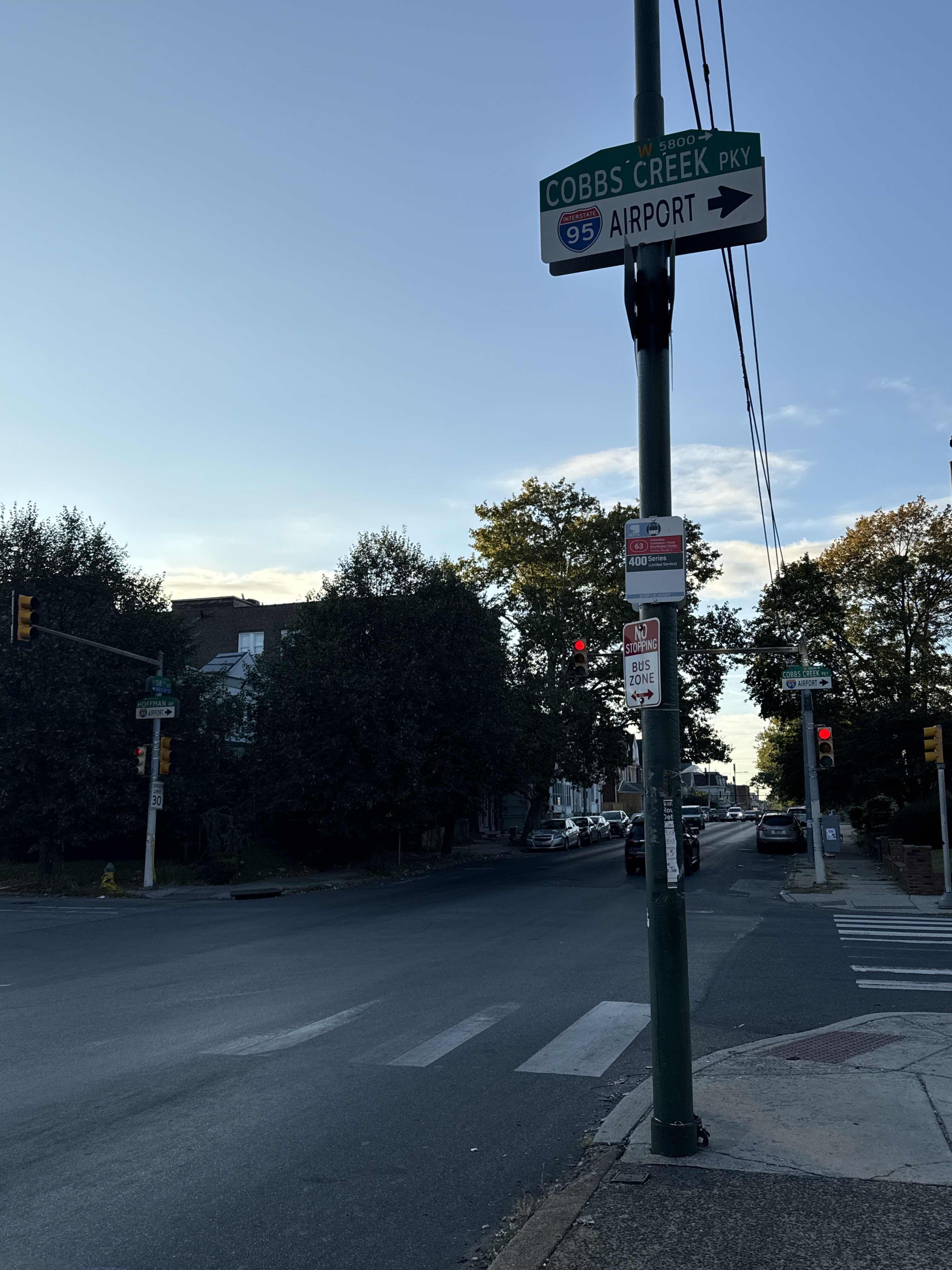
1118 Cobbs Creek Pky, Philadelphia, PA, USA
This stop serves SEPTA’s lines
Popular routes from 58th St & Hoffman Av stop, Philadelphia
- Angora
Train station near 58th St & Hoffman Av station
- 58th St & Hoffman Av,
- Baltimore Av & 58th St
Bus stops near 58th St & Hoffman Av stop
- Jefferson Station,
- Wyoming,
- Spring Garden St & 17th St,
- Macdade Blvd & Morton Av - FS,
- Ridge Rd & Market St,
- Lehigh Av & 21st St,
- Broad St & Cowpath Rd,
- C St & Roosevelt Blvd,
- Wissahickon,
- Chester Pike & Sharon Av,
- Haverford Av & 63rd St,
- Morris St & 18th St,
- 13th St Station,
- Allegheny Station,
- Exton Square Mall & North Entrance,
- Philmont Av & Byberry Rd - FS,
- Thorndale,
- Allegheny Av & Jasper St,
- 5th St & Market St - Fs,
- Drexel Rd & City Line Av
Popular public transit stations in Philadelphia
Get around Philadelphia by public transit!
Traveling around Philadelphia has never been so easy. See step by step directions as you travel to any attraction, street or major public transit station. View bus and train schedules, arrival times, service alerts and detailed routes on a map, so you know exactly how to get to anywhere in Philadelphia.
When traveling to any destination around Philadelphia use Moovit's Live Directions with Get Off Notifications to know exactly where and how far to walk, how long to wait for your line, and how many stops are left. Moovit will alert you when it's time to get off — no need to constantly re-check whether yours is the next stop.
Wondering how to use public transit in Philadelphia or how to pay for public transit in Philadelphia? Moovit public transit app can help you navigate your way with public transit easily, and at minimum cost. It includes public transit fees, ticket prices, and costs. Looking for a map of Philadelphia public transit lines? Moovit public transit app shows all public transit maps in Philadelphia with all Bus, Train, Metro, Light Rail and Cable Car routes and stops on an interactive map.
Philadelphia has 5 transit type(s), including: Bus, Train, Metro, Light Rail and Cable Car, operated by several transit agencies, including SEPTA Subway, SEPTA Rail, SEPTA, SEPTA Trolley, NJ Transit Rail, NJ Transit, Port Authority Transit Corporation, Navy Yard, Penn Transit, Drexel University, Pottstown Area Rapid Transit (PART), Fullington Tours, Chescobus, Amtrak and Greyhound-us