How to get to Ala by train?
Click on the train route to see step by step directions with maps, line arrival times and updated time schedules.
What are the closest stations to Ala?
The closest stations to Ala are:
- Gorlice Glinik is 9 meters away, 1 min walk.
- Gorlice Zagórzany is 3464 meters away, 45 min walk.
Which train lines stop near Ala?
These train lines stop near Ala: IC 30110, IC 30112, IC 33112.
What’s the nearest train station to Ala in Warsaw?
The nearest train station to Ala in Warsaw is Gorlice Glinik. It’s a 1 min walk away.
What time is the first train to Ala in Warsaw?
The IC 33110 is the first train that goes to Ala in Warsaw. It stops nearby at 7:13 AM.
What time is the last train to Ala in Warsaw?
The IC 30110 is the last train that goes to Ala in Warsaw. It stops nearby at 8:42 PM.
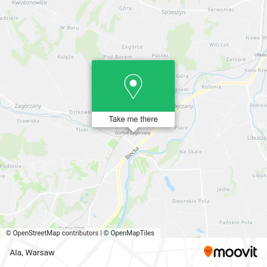
See Ala, Warsaw, on the map
Public Transit to Ala in Warsaw
Wondering how to get to Ala in Warsaw? Moovit helps you find the best way to get to Ala with step-by-step directions from the nearest public transit station.
Moovit provides free maps and live directions to help you navigate through your city. View schedules, routes, timetables, and find out how long does it take to get to Ala in real time.
Looking for the nearest stop or station to Ala? Check out this list of stops closest to your destination: Gorlice Glinik; Gorlice Zagórzany.
Train: IC 30110, IC 30112, IC 33112, KMŁ, REG, REG, KMŁ, IC 33110.
Want to see if there’s another route that gets you there at an earlier time? Moovit helps you find alternative routes or times. Get directions from and directions to Ala easily from the Moovit App or Website.
We make riding to Ala easy, which is why over 1.5 million users, including users in Warsaw, trust Moovit as the best app for public transit. You don’t need to download an individual bus app or train app, Moovit is your all-in-one transit app that helps you find the best bus time or train time available.
For information on prices of train and bus, costs and ride fares to Ala, please check the Moovit app.
Use the app to navigate to popular places including to the airport, hospital, stadium, grocery store, mall, coffee shop, school, college, and university.
Ala Address: ulica ks. Stanisława Tokarza 4A, 38-300 Gorlice street in Warsaw
- Stary Dworzec,
- Gorlice Stacja Zagórzany PKP,
- Ppm Color,
- Dariusz Stec Usługi Informatyczne Stedar,
- Artur Gubała Simplight,
- Wiking Pawel Szerlag,
- Sklep i Hurtonia Odzieży Używanej Sc Cisowska Helena i Cisowski Marian Gorlice,
- Abc Elektronik sp. z o.o.,
- Ryczek Anna. Biurowe Usługi,
- Urbaa - Architektura i Wnętrza - Jarosław Urbański,
- Gorlice Rampa,
- White Magic - Sklep z Biżuterią,
- Bartosz Biliński Firma Usługowa,
- Cougar,
- P.B.H. S.A. Sklep Odzieżowy Quiosque,
- New Garner,
- Ryszard Wilczkiewicz Usługi Brukarsko-Budowlane Bruk-Bud,
- Krzysztof Gieracki,
- Leszek Chęciński Liten PHU,
- Marek Gurtat Firma Handlowa
Places Near Ala (Warsaw)
- Galeria Mokotów, Warsaw,
- Szaserów - Szpital, Warsaw,
- Torwar, Warsaw,
- Wołoska-Szpital 01, Warsaw,
- Wołoska, Warsaw,
- Banacha - Szpital Kliniczny, Warsaw,
- Galeria Północna, Warsaw,
- CH Arkadia, Warsaw,
- PGE Narodowy, Warsaw,
- Centralny Szpital Kliniczny MSWiA ul. Wołoska, Warsaw,
- Domaniewska, Warsaw,
- Instytut Kardiologii w Aninie, Warsaw,
- Sejm Rp, Warsaw,
- Szpital Bielański, Warsaw,
- Szpital Czerniakowski, Warsaw,
- Szpital Spartanska, Warsaw,
- Szpital Orłowskiego, Warsaw,
- Cmentarz Bródnowski, Warsaw,
- Stare Miasto, Warsaw,
- Postępu, Warsaw
How to get to popular places in Warsaw with public transit
Get around Warsaw by public transit!
Traveling around Warsaw has never been so easy. See step by step directions as you travel to any attraction, street or major public transit station. View bus and train schedules, arrival times, service alerts and detailed routes on a map, so you know exactly how to get to anywhere in Warsaw.
When traveling to any destination around Warsaw use Moovit's Live Directions with Get Off Notifications to know exactly where and how far to walk, how long to wait for your line, and how many stops are left. Moovit will alert you when it's time to get off — no need to constantly re-check whether yours is the next stop.
Wondering how to use public transit in Warsaw or how to pay for public transit in Warsaw? Moovit public transit app can help you navigate your way with public transit easily, and at minimum cost. It includes public transit fees, ticket prices, and costs. Looking for a map of Warsaw public transit lines? Moovit public transit app shows all public transit maps in Warsaw with all Bus, Train, Metro, Light Rail, Ferry and Cable Car routes and stops on an interactive map.
Warsaw has 6 transit type(s), including: Bus, Train, Metro, Light Rail, Ferry and Cable Car, operated by several transit agencies, including Warszawski Transport Publiczny, Warszawska Kolej Dojazdowa, Koleje Mazowieckie, ZTP Kraków, Miasto Piastów, Miasto Ząbki, Koleje Małopolskie, Komunikacja Miejska Łomianki, Gmina Pruszków, MPK Wrocław, MZDiK Radom, UM w Grodzisku Mazowieckim, UM w Nowym Dworze Mazowieckim, UM Płońsk and Koleje Dolnośląskie