Alken St. station - Sunday schedule
| Line | Direction | Time |
|---|---|---|
| 030 | Silkeborg St. | 7:32 AM |
| 030 | Aarhus H | 8:22 AM |
| 030 | Silkeborg St. | 8:32 AM |
| 030 | Aarhus H | 9:23 AM |
| 030 | Silkeborg St. | 9:32 AM |
| 030 | Aarhus H | 10:23 AM |
| 030 | Silkeborg St. | 10:32 AM |
| 030 | Aarhus H | 11:23 AM |
| 030 | Silkeborg St. | 11:32 AM |
| 030 | Aarhus H | 12:23 PM |
| 030 | Silkeborg St. | 12:32 PM |
| 030 | Aarhus H | 1:23 PM |
| 030 | Silkeborg St. | 1:32 PM |
| 030 | Aarhus H | 2:23 PM |
| 030 | Silkeborg St. | 2:32 PM |
| 030 | Aarhus H | 3:22 PM |
| 030 | Silkeborg St. | 3:32 PM |
| 030 | Aarhus H | 4:22 PM |
| 030 | Silkeborg St. | 4:32 PM |
| 030 | Aarhus H | 5:22 PM |
| 030 | Silkeborg St. | 5:32 PM |
| 030 | Aarhus H | 6:22 PM |
| 030 | Silkeborg St. | 6:32 PM |
| 030 | Aarhus H | 7:22 PM |
| 030 | Silkeborg St. | 7:32 PM |
Directions to Alken St. station (Skanderborg) with public transit
The following transit lines have routes that pass near Alken St.
 Bus: 311, 330, 502.
- Train: 030.
How to get to Alken St. station by bus?
Click on the bus route to see step by step directions with maps, line arrival times and updated time schedules.
How to get to Alken St. station by train?
Click on the train route to see step by step directions with maps, line arrival times and updated time schedules.
Which bus lines stop near Alken St.?
These bus lines stop near Alken St.: 311, 330, 502.
Which train line stops near Alken St.?
030 (Aarhus H)
See Alken St. station, Skanderborg, on the map
Public transit to Alken St. station in Skanderborg
Looking for directions to Alken St. in Skanderborg, Denmark?
Download the Moovit App to find the current schedule and step-by-step directions for Train or Bus routes that pass through Alken St..
Bus: 311, 330, 502.Train: 030.
We make riding on public transit to Alken St. easy, which is why over 1.7 billion users, including users in Skanderborg trust Moovit as the best app for public transit.
Use the app to navigate to popular places including to the airport, hospital, stadium, grocery store, mall, coffee shop, school, college, and university.
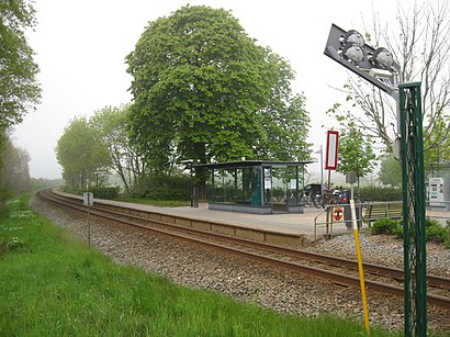
The station has the following entrances: Alkenvej
The first line to this station is 030, at 7:32 AM, and the last line is 030 at 12:28 AM.
Alkenvej 44A, Denmark
This station serves GoCollective and GoCollective’s lines
- Ishøj St.,
- Rigshospitalet Syd (Fredensgade),
- Købmagergade V Fynsgade (Fredericia),
- Lyneborggade (Holmbladsgade),
- Stenbjergvej (Øster Uttrup Vej/ Aalborg),
- Hjortshøj (Letbane),
- Spodsbjerg Færgehavn (Langeland Kommune),
- Klostertorvet (Aarhus Kom),
- Højstrup St.,
- Regionshospitalet/Kirketerpvej (Randers Kom),
- Stærmosegårdsvej / Munkebjergv (Odense Kommune),
- Billund Lufthavn / Billund Airport,
- Techcollege (Rørdalsvej / Aalborg),
- Aalborg St. (Perron C5),
- Brønshøj Torv (Krabbesholmvej),
- Haraldsgade (Lyngbyvej),
- Dybbølsbro St. (Ingerslevsgade),
- Sjællandsgade/Herningsholmskolen (Herning Kom),
- Mega Syd/Ringvej Syd (Aarhus Kom),
- Paris (Lemvig Kom)
Popular public transit stations in Skanderborg
Get around Skanderborg by public transit!
Traveling around Skanderborg has never been so easy. See step by step directions as you travel to any attraction, street or major public transit station. View bus and train schedules, arrival times, service alerts and detailed routes on a map, so you know exactly how to get to anywhere in Skanderborg.
When traveling to any destination around Skanderborg use Moovit's Live Directions with Get Off Notifications to know exactly where and how far to walk, how long to wait for your line, and how many stops are left. Moovit will alert you when it's time to get off — no need to constantly re-check whether yours is the next stop.
Wondering how to use public transit in Skanderborg or how to pay for public transit in Skanderborg? Moovit public transit app can help you navigate your way with public transit easily, and at minimum cost. It includes public transit fees, ticket prices, and costs. Looking for a map of Skanderborg public transit lines? Moovit public transit app shows all public transit maps in Skanderborg with all Bus, Train, Metro, Light Rail and Ferry routes and stops on an interactive map.
Denmark has 5 transit type(s), including: Bus, Train, Metro, Light Rail and Ferry, operated by several transit agencies, including Metroselskabet, DSB S-tog, Lokaltog A/S, Midttrafik, Odense Letbane, DSB, NT, GoCollective, Skånetrafiken, Movia, FYNBUS, Sydtrafik, Bornholms Trafik, Samsø Bus and Citybus