Directions to Angono Petroglyphs (Binangonan) with public transportation
The following transit lines have routes that pass near Angono Petroglyphs
 Bus: LTFRB-PUJ1153, LTFRB-PUJ1315, LTFRB-PUJ2491, JEEP.
Bus stop near Angono Petroglyphs in Binangonan
- Un- Named Road, Teresa, Manila, 143 min walk,
Bus lines to Angono Petroglyphs in Binangonan
- JEEP, Un- Named Road Near J. Sumulong Rd, Teresa, Manila,
- Etw Entrusting the Word Fellowship San Carlos,
- Lafarge Cement,
- Angono Petroglyphs Museum,
- Azucena St,
- Antenna Hill,
- Roselynd Homes,
- Doña Justa Village Phase 2,
- Villa Criscar Resort binangonan,
- Villa Criscar Resort,
- Guijo St. Dona Justa Village,
- Don Jose Ynares, Sr. Memorial Elementary School,
- Vicente Manansala Historical Landmark,
- Victoria Village,
- U- Bar ni Tatsilog @ Adelina Street San Carlos Subdivision, Tayuman Binangonan Rizal,
- Constellation Homes Chapel,
- 38 Corazon San Carlos Tayuman Binangonan, Rizal,
- Fruitas Robinsons Galleria,
- Casa Martin Resort,
- 31 Lina Luz St,
- Ontario St & Paris St
Places Near Angono Petroglyphs (Binangonan)
- Bridgetowne, Quezon City,
- Sm Manila, Manila,
- Fisher Mall, Quezon City,
- East Avenue Medical Center, Quezon City,
- NAIA Terminal 3, Manila,
- Robinsons Place (Robinsons Place Ermita), Manila,
- SB Park, Tandang Sora, Q.C., Quezon City,
- DSWD - Central Office, Batasan Complex, Quezon City,
- WWW.Youjizz.Com, Antipolo City,
- Civil Service Commission NCR Office, Quezon City,
- CCF Center Main, Pasig City,
- SM City North EDSA, Quezon City,
- Parqal Mall, Parañaque,
- PSA - East Ave, Quezon City,
- Jones Bridge, Manila,
- Eton Centris, Quezon City,
- Dfa Aseana, Parañaque,
- Lemon Square Munoz QC, Quezon City,
- Ayala Malls Feliz, Pasig City,
- Double Dragon Plaza
How to get to popular places in Manila with public transit
What are the closest stations to Angono Petroglyphs?
The closest stations to Angono Petroglyphs are:
- Un- Named Road, Teresa, Manila is 11067 meters away, 143 min walk.
Which bus lines stop near Angono Petroglyphs?
These bus lines stop near Angono Petroglyphs: LTFRB-PUJ1153, LTFRB-PUJ1315, LTFRB-PUJ2491.
See Angono Petroglyphs, Binangonan, on the map
Public Transit to Angono Petroglyphs in Binangonan
Wondering how to get to Angono Petroglyphs in Binangonan? Moovit helps you find the best way to get to Angono Petroglyphs with step-by-step directions from the nearest public transit station.
Moovit provides free maps and live directions to help you navigate through your city. View schedules, routes, timetables, and find out how long does it take to get to Angono Petroglyphs in real time.
Looking for the nearest stop or station to Angono Petroglyphs? Check out this list of stops closest to your destination: Un- Named Road.
Bus: LTFRB-PUJ1153, LTFRB-PUJ1315, LTFRB-PUJ2491, JEEP.
Want to see if there’s another route that gets you there at an earlier time? Moovit helps you find alternative routes or times. Get directions from and directions to Angono Petroglyphs easily from the Moovit App or Website.
We make riding to Angono Petroglyphs easy, which is why over 1.5 million users, including users in Binangonan, trust Moovit as the best app for public transit. You don’t need to download an individual bus app or train app, Moovit is your all-in-one transit app that helps you find the best bus time or train time available.
For information on prices of bus, costs and ride fares to Angono Petroglyphs, please check the Moovit app.
Use the app to navigate to popular places including to the airport, hospital, stadium, grocery store, mall, coffee shop, school, college, and university.
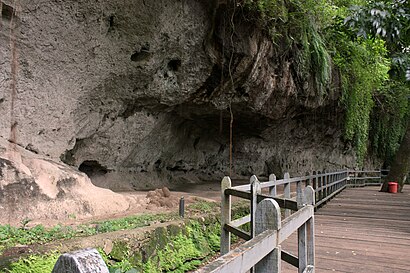
Angono Petroglyphs Address: tunnel street in Binangonan
Get around Binangonan by public transit!
Traveling around Binangonan has never been so easy. See step by step directions as you travel to any attraction, street or major public transit station. View bus and train schedules, arrival times, service alerts and detailed routes on a map, so you know exactly how to get to anywhere in Binangonan.
When traveling to any destination around Binangonan use Moovit's Live Directions with Get Off Notifications to know exactly where and how far to walk, how long to wait for your line, and how many stops are left. Moovit will alert you when it's time to get off — no need to constantly re-check whether yours is the next stop.
Wondering how to use public transit in Binangonan or how to pay for public transit in Binangonan? Moovit public transit app can help you navigate your way with public transit easily, and at minimum cost. It includes public transit fees, ticket prices, and costs. Looking for a map of Binangonan public transit lines? Moovit public transit app shows all public transit maps in Binangonan with all Bus and Train routes and stops on an interactive map.
Manila has 2 transit type(s), including: Bus and Train, operated by several transit agencies, including MRTC, LRTA, PNR, LTFRB, BGC Bus, P2P and UV Express