How to get to Apisource by bus?
Click on the bus route to see step by step directions with maps, line arrival times and updated time schedules.
From New Carrollton MARC, Prince George's County
33 minFrom Montgomery Blair High School, Montgomery County
90 minFrom Walmart Supercenter Fort Totten - Riggs Rd NE, Washington
72 minFrom Hyattsville District Court, Prince George's County
59 minFrom Columbia MD-195, Montgomery County
73 minFrom Bowie, MD, Prince George's County
42 minFrom Hyattsville, MD, Prince George's County
61 minFrom Walmart, Washington
72 minFrom National Archives at College Park, Prince George's County
63 minFrom Landover, Maryland, Prince George's County
69 min
How to get to Apisource by train?
Click on the train route to see step by step directions with maps, line arrival times and updated time schedules.
How to get to Apisource by metro?
Click on the metro route to see step by step directions with maps, line arrival times and updated time schedules.
Bus stops near Apisource in Prince George's County
Metro station near Apisource in Prince George's County
- Greenbelt, 30 min walk,VIEW
Bus lines to Apisource in Prince George's County
What are the closest stations to Apisource?
The closest stations to Apisource are:
- Greenbelt Rd + Walker Dr is 309 yards away, 4 min walk.
- Greenbelt Rd & Walker Dr is 309 yards away, 4 min walk.
- Edmonston Rd+Breezewood Dr is 1185 yards away, 14 min walk.
- Greenbelt is 2533 yards away, 30 min walk.
Which bus lines stop near Apisource?
These bus lines stop near Apisource: P14, P20, P22.
Which train line stops near Apisource?
MARC (Inbound - Camden)
Which metro line stops near Apisource?
GREEN (Greenbelt)
What’s the nearest metro station to Apisource in Prince George's County?
The nearest metro station to Apisource in Prince George's County is Greenbelt. It’s a 30 min walk away.
What’s the nearest bus station to Apisource in Prince George's County?
The nearest bus stations to Apisource in Prince George's County are Greenbelt Rd + Walker Dr and Greenbelt Rd & Walker Dr. The closest one is a 4 min walk away.
What time is the first metro to Apisource in Prince George's County?
The GREEN is the first metro that goes to Apisource in Prince George's County. It stops nearby at 4:59 AM.
What time is the last metro to Apisource in Prince George's County?
The GREEN is the last metro that goes to Apisource in Prince George's County. It stops nearby at 12:44 AM.
What time is the first train to Apisource in Prince George's County?
The MARC is the first train that goes to Apisource in Prince George's County. It stops nearby at 5:39 AM.
What time is the last train to Apisource in Prince George's County?
The MARC is the last train that goes to Apisource in Prince George's County. It stops nearby at 8:01 PM.
What time is the first bus to Apisource in Prince George's County?
The P14 is the first bus that goes to Apisource in Prince George's County. It stops nearby at 5:03 AM.
What time is the last bus to Apisource in Prince George's County?
The P20 is the last bus that goes to Apisource in Prince George's County. It stops nearby at 12:16 AM.
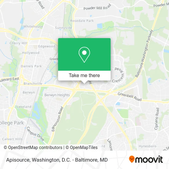
See Apisource, Prince George's County, on the map
Public Transit to Apisource in Prince George's County
Wondering how to get to Apisource in Prince George's County? Moovit helps you find the best way to get to Apisource with step-by-step directions from the nearest public transit station.
Moovit provides free maps and live directions to help you navigate through your city. View schedules, routes, timetables, and find out how long does it take to get to Apisource in real time.
Looking for the nearest stop or station to Apisource? Check out this list of stops closest to your destination: Greenbelt Rd + Walker Dr; Greenbelt Rd & Walker Dr; Edmonston Rd+Breezewood Dr; Greenbelt.
Bus: P14, P20, P22.Train: MARC.Metro: GREEN, YELLOW, MARC.
Want to see if there’s another route that gets you there at an earlier time? Moovit helps you find alternative routes or times. Get directions from and directions to Apisource easily from the Moovit App or Website.
We make riding to Apisource easy, which is why over 1.5 million users, including users in Prince George's County, trust Moovit as the best app for public transit. You don’t need to download an individual bus app or train app, Moovit is your all-in-one transit app that helps you find the best bus time or train time available.
For information on prices of bus, metro and train, costs and ride fares to Apisource, please check the Moovit app.
Use the app to navigate to popular places including to the airport, hospital, stadium, grocery store, mall, coffee shop, school, college, and university.
Apisource Address: 7850 Walker Dr Greenbelt, MD 20770 street in Prince George's County
- Donna Fleshman, Pa-C - Persona Doctors,
- Hilton Garden Inn Washington Dc / Greenbelt Hotel Greenbelt,
- Hilton Garden Inn Washington DC Greenbelt,
- Atf,
- Bozzuto Management Company,
- Sonesta Select Greenbelt College Park,
- Exit 23 - MD 201 (Kenilworth Avenue) / Greenbelt, Bladensburg,
- USDA Shuttle GWCC/HQ,
- Oai,
- R12 Deanwood,
- Alshalabi Mohammed MD (Mohannad Alshalabi MD-Shelby Women Health),
- Cherry Acupressure,
- Greenbelt Road (MD 193) & Kenilworth Avenue (MD 201),
- Greenbelt Middle School (Prince George's County Public Schools, Middle Schools),
- FedEx,
- Franklin Park At Greenbelt Station Apartments,
- GPS Consulting & Property Management Group,
- Greenbelt Middle School,
- Greenbelt Park,
- Empirian Property Management
Places Near Apisource (Prince George's County)
- Rock Creek Tennis Center, Washington,
- Washington National Cathedral, Washington,
- Sibley Memorial Hospital, Washington,
- Washington DC VA Medical Center, Washington,
- The Anthem, Washington,
- Georgetown, Washington,
- Westfield Montgomery Mall, Montgomery County,
- PG Mall, Prince George's County,
- Marriott Marquis Washington, DC, Washington,
- Amazon Hq2, Arlington County,
- National Theatre, Washington,
- Warner Theatre, Washington,
- Museum Of The Bible, Washington,
- Camden Yards, Baltimore,
- Basilica of the National Shrine, Washington,
- National Museum of African American History and Culture, Washington,
- Pennsylvania Ave NW (3rd st and pennsylvania), Washington,
- Capital One Arena, Washington,
- National Zoo, Washington,
- M&T Bank Stadium, Baltimore
How to get to popular places in Washington, D.C. - Baltimore, MD with public transit
Get around Prince George's County by public transit!
Traveling around Prince George's County has never been so easy. See step by step directions as you travel to any attraction, street or major public transit station. View bus and train schedules, arrival times, service alerts and detailed routes on a map, so you know exactly how to get to anywhere in Prince George's County.
When traveling to any destination around Prince George's County use Moovit's Live Directions with Get Off Notifications to know exactly where and how far to walk, how long to wait for your line, and how many stops are left. Moovit will alert you when it's time to get off — no need to constantly re-check whether yours is the next stop.
Wondering how to use public transit in Prince George's County or how to pay for public transit in Prince George's County? Moovit public transit app can help you navigate your way with public transit easily, and at minimum cost. It includes public transit fees, ticket prices, and costs. Looking for a map of Prince George's County public transit lines? Moovit public transit app shows all public transit maps in Prince George's County with all Bus, Train, Metro, Light Rail and Ferry routes and stops on an interactive map.
Washington, D.C. - Baltimore, MD has 5 transit type(s), including: Bus, Train, Metro, Light Rail and Ferry, operated by several transit agencies, including WMATA, Montgomery County Ride On, Fairfax Connector, TheBus, PRTC, DASH - Alexandria, Arlington Transit (ART), RTA of Central Maryland, MDOT MTA, MDOT MTA Light RailLink, MDOT MTA Commuter Bus, MDOT MTA Local Bus, FXBGO!, Virginia Railway Express (VRE) and MARC