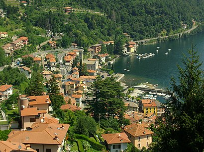
See Argegno on the map
Directions to Argegno with public transportation
The following transit lines have routes that pass near Argegno
 Bus:
Bus: - Ferry:
How to get to Argegno by bus?
Click on the bus route to see step by step directions with maps, line arrival times and updated time schedules.
How to get to Argegno by ferry?
Click on the ferry route to see step by step directions with maps, line arrival times and updated time schedules.
Bus stations near Argegno
- Argegno - Piazza Roma (Pontile),1 min walk,
Ferry stations near Argegno
- Argegno,47 min walk,
Bus lines to Argegno
- C10,Como,
- C20,Argegno,
- C21,San Fedele,
- C25,Como S. Giovanni FS,
What are the closest stations to Argegno?
The closest stations to Argegno are:
- Argegno - Piazza Roma (Pontile) is 53 meters away, 1 min walk.
- Argegno is 3648 meters away, 47 min walk.
Which bus line stops near Argegno?
C10
Which ferry line stops near Argegno?
⛴
What’s the nearest bus stop to Argegno?
The nearest bus stop to Argegno is Argegno - Piazza Roma (Pontile). It’s a 1 min walk away.
What time is the first bus to Argegno?
The C10 is the first bus that goes to Argegno. It stops nearby at 7:03 AM.
What time is the last bus to Argegno?
The C25 is the last bus that goes to Argegno. It stops nearby at 12:12 AM.
What time is the first ferry to Argegno?
The ⛴ is the first ferry that goes to Argegno. It stops nearby at 8:40 AM.
What time is the last ferry to Argegno?
The ⛴ is the last ferry that goes to Argegno. It stops nearby at 7:11 PM.
How much is the train fare to Argegno?
The train fare to Argegno costs about €1.40 - €9.30.
How much is the bus fare to Argegno?
The bus fare to Argegno costs about €5.00.
See Argegno on the map
Public Transportation to Argegno
Wondering how to get to Argegno, Italy? Moovit helps you find the best way to get to Argegno with step-by-step directions from the nearest public transit station.
Moovit provides free maps and live directions to help you navigate through your city. View schedules, routes, timetables, and find out how long does it take to get to Argegno in real time.
Looking for the nearest stop or station to Argegno? Check out this list of stops closest to your destination: Argegno - Piazza Roma (Pontile); Argegno.
Bus:Ferry:
Want to see if there’s another route that gets you there at an earlier time? Moovit helps you find alternative routes or times. Get directions from and directions to Argegno easily from the Moovit App or Website.
We make riding to Argegno easy, which is why over 1.5 million users, including users in Milan and Lombardy, trust Moovit as the best app for public transit. You don’t need to download an individual bus app or train app, Moovit is your all-in-one transit app that helps you find the best bus time or train time available.
For information on prices of bus, train and ferry, costs and ride fares to Argegno, please check the Moovit app.
Use the app to navigate to popular places including to the airport, hospital, stadium, grocery store, mall, coffee shop, school, college, and university.
Location: Milan and Lombardy
Popular routes to Argegno
Popular routes from Argegno
Attractions near Argegno
Argegno Piazza Roma Pontile,Valle D'intelvi,Acqua,Prestinari Francesca,Il Mulino di Marina - Lake Como,Gilardoni Andrea,Ca Vegia,Sana Finestra,Banca Popolare di Sondrio-Societa' Cooperativa per Azioni,Funivia Argegno Pigra,Nixora Solutions,Casa Gabriella,Argegno,Bazzi Angelo,Villa Belvedere (Boutique Hotel Belvedere Como),Casa Mille Luci - Lago di Como,Parrocchia Ss Trinità,Lido Di Argegno,lido di argegno,Villa LillaHow to get to popular attractions in Milan and Lombardy with public transit
Yoox Net-à-Porter S.p.A., Milano,Piazza Tricolore, Milano,Piazza Cinque Giornate, Milano,Stazione Peschiera del Garda, Peschiera Del Garda,Accursio/Sonnino, Milano,Piazza Miani, Milano,Aeroporto Di Linate, Segrate,Bicocca Village, Milano,Niguarda Centro, Milano,NooN, Milano,The Hub Hotel, Milano,Via Ripamonti - Via Quaranta, Milano,Colonne Di San Lorenzo, Milano,Golgi - Via Celoria, Milano,Corbetta, Corbetta,Piazza Leonardo Da Vinci - Politecnico, Milano,Stazione Di Novara, Novara,Iulm University, Milano,Repubblica, Milano,Piazza Cavour, MilanoGet around Milan and Lombardy by public transit!
Traveling around Milan and Lombardy has never been so easy. See step by step directions as you travel to any attraction, street or major public transit station. View bus and train schedules, arrival times, service alerts and detailed routes on a map, so you know exactly how to get to anywhere in Milan and Lombardy.
When traveling to any destination around Milan and Lombardy use Moovit's Live Directions with Get Off Notifications to know exactly where and how far to walk, how long to wait for your line, and how many stops are left. Moovit will alert you when it's time to get off — no need to constantly re-check whether yours is the next stop.
Wondering how to use public transit in Milan and Lombardy or how to pay for public transit in Milan and Lombardy? Moovit public transit app can help you navigate your way with public transit easily, and at minimum cost. It includes public transit fees, ticket prices, and costs. Looking for a map of Milan and Lombardy public transit lines? Moovit public transit app shows all public transit maps in Milan and Lombardy with all bus, train or ferry routes and stops on an interactive map.
Milan and Lombardy has 3 transit type(s), including: bus, train or ferry, operated by several transit agencies, including ATM, ATM, ATM, Trenord, Trenitalia, Autoguidovie S.p.A., NET, Movibus, ATM, ASF Autolinee, Autostradale S.r.l., Terravision, AirPullman, TEB and ATB