Arrott St & Large St stop - Sunday schedule
| Line | Direction | Time |
|---|---|---|
| 41 | Chelten-Wissahickon | 5:12 AM |
| 75 | Wayne Junction | 5:21 AM |
| K | Ridge-Midvale | 5:33 AM |
| 75 | Wayne Junction | 5:51 AM |
| K | Ridge-Midvale | 5:59 AM |
| 41 | Chelten-Wissahickon | 6:07 AM |
| 75 | Wayne Junction | 6:20 AM |
| K | Ridge-Midvale | 6:28 AM |
| 89 | Front-Dauphin | 6:31 AM |
| 75 | Wayne Junction | 6:50 AM |
| K | Ridge-Midvale | 6:57 AM |
| 41 | Chelten-Wissahickon | 7:07 AM |
| 75 | Wayne Junction | 7:20 AM |
| K | Ridge-Midvale | 7:27 AM |
| 89 | Front-Dauphin | 7:31 AM |
| 75 | Wayne Junction | 7:49 AM |
| K | Ridge-Midvale | 7:54 AM |
| 41 | Chelten-Wissahickon | 8:07 AM |
| 75 | Wayne Junction | 8:19 AM |
| K | Ridge-Midvale | 8:23 AM |
| 89 | Front-Dauphin | 8:31 AM |
| 75 | Wayne Junction | 8:48 AM |
| K | Ridge-Midvale | 8:53 AM |
| 41 | Chelten-Wissahickon | 9:06 AM |
| 75 | Wayne Junction | 9:17 AM |
Directions to Arrott St & Large St stop (Philadelphia) with public transit
The following transit lines have routes that pass near Arrott St & Large St
 Bus: 89, K, 41, 75.
- Train: TRE.
- Metro: L1.
- Cable Car: 75.
How to get to Arrott St & Large St stop by bus?
Click on the bus route to see step by step directions with maps, line arrival times and updated time schedules.
How to get to Arrott St & Large St stop by train?
Click on the train route to see step by step directions with maps, line arrival times and updated time schedules.
How to get to Arrott St & Large St stop by metro?
Click on the metro route to see step by step directions with maps, line arrival times and updated time schedules.
Bus stops near Arrott St & Large St stop in Philadelphia
- Foulkrod St & Large St , 3 min walk,
- Arrott St & Horrocks St , 3 min walk,
Bus lines to Arrott St & Large St stop in Philadelphia
- K, Ridge-Midvale,
- 41, Chelten-Wissahckn to Richmnd-Orthdx,
- 75, Wayne Junct to Arrott Transit Ctr,
- 89, Front-Dauphin to Arrott Transit Ctr,
What are the closest stations to Arrott St & Large St?
The closest stations to Arrott St & Large St are:
- Foulkrod St & Large St stop is 145 yards away, 3 min walk.
- Arrott St & Horrocks St stop is 212 yards away, 3 min walk.
Which bus lines stop near Arrott St & Large St?
These bus lines stop near Arrott St & Large St: 89, K.
Which train line stops near Arrott St & Large St?
TRE (#Tre9719 - Trenton)
Which metro line stops near Arrott St & Large St?
L1 (Frankford Transit Center)
Which cable car line stops near Arrott St & Large St?
75 (Wayne Junction)
What’s the nearest bus station to Arrott St & Large St in Philadelphia?
The nearest bus stations to Arrott St & Large St in Philadelphia are Foulkrod St & Large St and Arrott St & Horrocks St. The closest one is a 3 min walk away.
Arrott St & Large St station
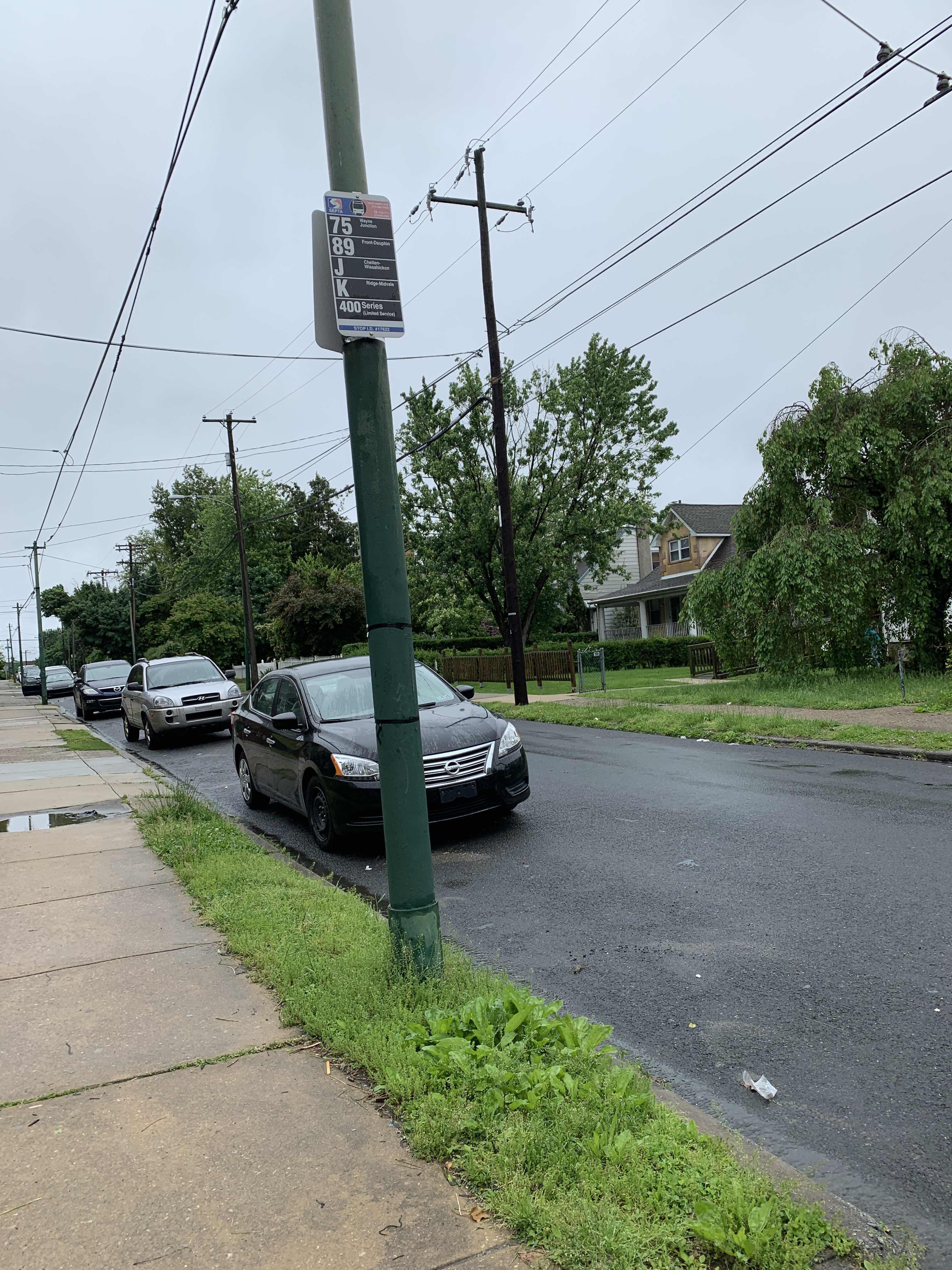 Taken by Anonymous
See Arrott St & Large St stop, Philadelphia, on the map
Public transit to Arrott St & Large St stop (ID: 17622) in Philadelphia
Looking for directions to Arrott St & Large St in Philadelphia, United States?
Download the Moovit App to find the current schedule and step-by-step directions for Bus, Metro, Cable Car or Train routes that pass through Arrott St & Large St.
Looking for the nearest stops closest to Arrott St & Large St ? Check out this list of closest stops to your destination: Foulkrod St & Large St ; Arrott St & Horrocks St .
Bus: 89, K, 41, 75.Train: TRE.Metro: L1.Cable Car: 75.
We make riding on public transit to Arrott St & Large St easy, which is why over 1.7 billion users, including users in Philadelphia trust Moovit as the best app for public transit.
Use the app to navigate to popular places including to the airport, hospital, stadium, grocery store, mall, coffee shop, school, college, and university.
Arrott St & Large St stop’s code is 17622
The first line to this stop is 41, at 5:12 AM, and the last line is K at 4:27 AM.
1105 Arrott St, Philadelphia, PA, USA
This stop serves SEPTA Trolley and SEPTA’s lines
- Foulkrod St & Large St ,
- Arrott St & Horrocks St
Bus stops near Arrott St & Large St stop
- Exton Square Mall & North Entrance,
- Verree Rd & Bloomfield Av,
- Welsh Rd & Blair Mill Rd - Mbns 1,
- Market St & 59th St - Fs,
- JFK Blvd at 30th St,
- Roosevelt Blvd & Longshore Av,
- Kroc Center,
- 8th St & Pine St ,
- 20th St & Chestnut St,
- Paoli,
- Essington Av & 68th St,
- Welsh Rd & Dewees St ,
- Ridge Rd & Market St,
- Market St & 15th St,
- Spring Mill,
- Philmont Av & Byberry Rd - FS,
- Broad St & Locust St,
- Market St at 30th St,
- Broad St & Catharine St,
- 17th St & Ben Franklin Pkwy
Popular public transit stations in Philadelphia
Get around Philadelphia by public transit!
Traveling around Philadelphia has never been so easy. See step by step directions as you travel to any attraction, street or major public transit station. View bus and train schedules, arrival times, service alerts and detailed routes on a map, so you know exactly how to get to anywhere in Philadelphia.
When traveling to any destination around Philadelphia use Moovit's Live Directions with Get Off Notifications to know exactly where and how far to walk, how long to wait for your line, and how many stops are left. Moovit will alert you when it's time to get off — no need to constantly re-check whether yours is the next stop.
Wondering how to use public transit in Philadelphia or how to pay for public transit in Philadelphia? Moovit public transit app can help you navigate your way with public transit easily, and at minimum cost. It includes public transit fees, ticket prices, and costs. Looking for a map of Philadelphia public transit lines? Moovit public transit app shows all public transit maps in Philadelphia with all Bus, Train, Metro, Light Rail and Cable Car routes and stops on an interactive map.
Philadelphia has 5 transit type(s), including: Bus, Train, Metro, Light Rail and Cable Car, operated by several transit agencies, including SEPTA Subway, SEPTA Rail, SEPTA, SEPTA Trolley, NJ Transit Rail, NJ Transit, Port Authority Transit Corporation, Navy Yard, Penn Transit, Drexel University, Pottstown Area Rapid Transit (PART), Fullington Tours, Chescobus, Amtrak and Greyhound-us