Artesia / Prairie stop - Saturday schedule
| Line | Direction | Time |
|---|---|---|
| 13 | Artesia Station | 6:19 AM |
| 2 | El Camino College | 6:26 AM |
| 344 | Harbor Gateway Transit Center | 6:44 AM |
| 13 | Artesia Station | 7:20 AM |
| 344 | Harbor Gateway Transit Center | 7:44 AM |
| 2 | El Camino College | 7:48 AM |
| 13 | Artesia Station | 8:21 AM |
| 344 | Harbor Gateway Transit Center | 8:43 AM |
| 2 | El Camino College | 8:57 AM |
| 13 | Artesia Station | 9:19 AM |
| 344 | Harbor Gateway Transit Center | 9:43 AM |
| 2 | El Camino College | 10:14 AM |
| 13 | Artesia Station | 10:20 AM |
| 344 | Harbor Gateway Transit Center | 10:43 AM |
| 13 | Artesia Station | 11:18 AM |
| 2 | El Camino College | 11:23 AM |
| 344 | Harbor Gateway Transit Center | 11:43 AM |
| 13 | Artesia Station | 12:18 PM |
| 2 | El Camino College | 12:39 PM |
| 344 | Harbor Gateway Transit Center | 12:42 PM |
| 13 | Artesia Station | 1:16 PM |
| 344 | Harbor Gateway Transit Center | 1:42 PM |
| 2 | El Camino College | 2:00 PM |
| 13 | Artesia Station | 2:17 PM |
| 344 | Harbor Gateway Transit Center | 2:42 PM |
Directions to Artesia / Prairie stop (Torrance) with public transit
The following transit lines have routes that pass near Artesia / Prairie
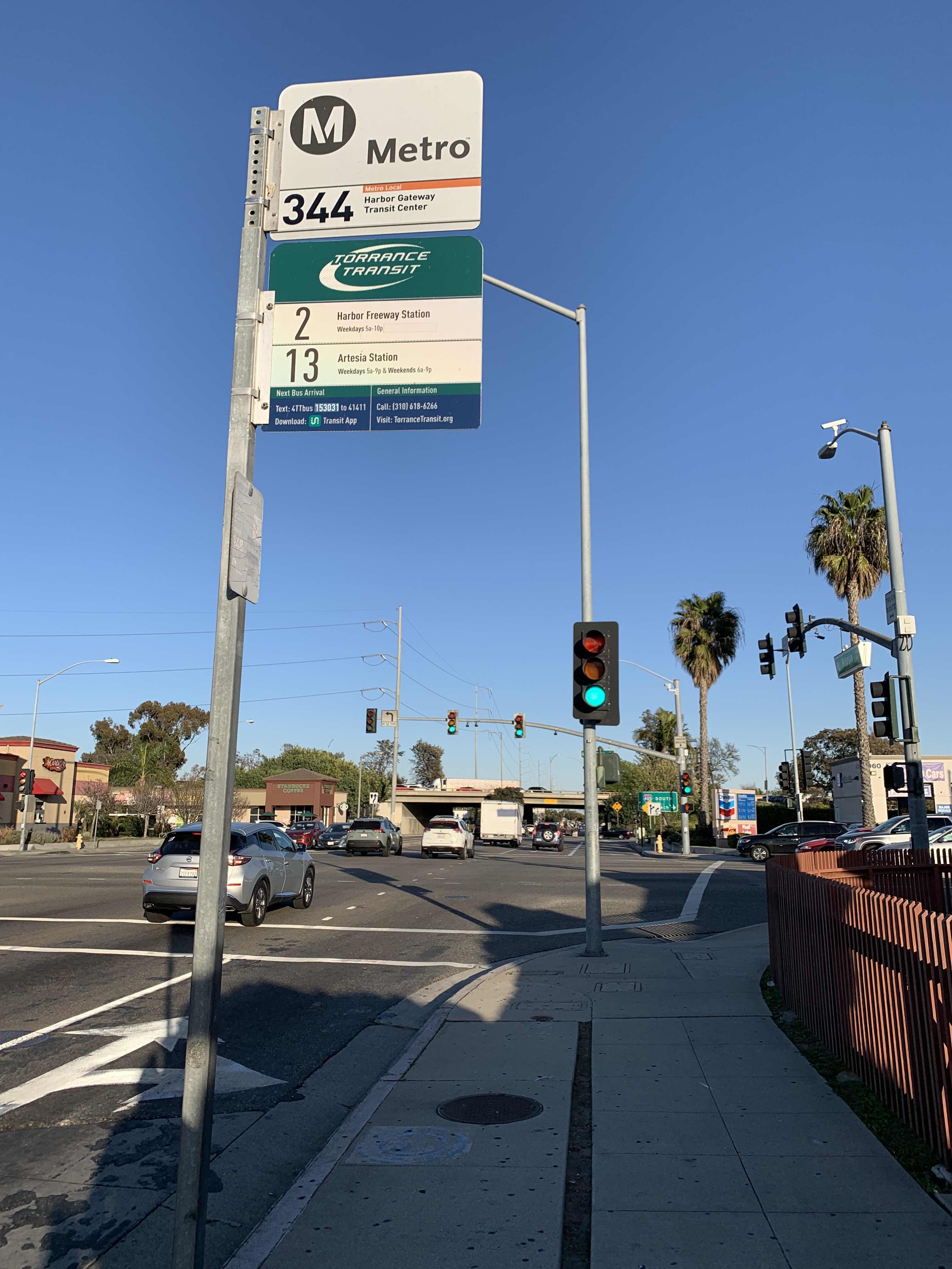
 Bus: 13, 210, 211/215, 3, 344.
- Subway: K LINE.
How to get to Artesia / Prairie stop by bus?
Click on the bus route to see step by step directions with maps, line arrival times and updated time schedules.
Bus stops near Artesia / Prairie stop in Torrance
- Prairie / Artesia, 1 min walk,
- Artesia / Prairie, 1 min walk,
- Redondo Beach / Prairie, 8 min walk,
- Freeman Ave & Redondo Beach Blvd, 10 min walk,
Subway stations near Artesia / Prairie station in Torrance
- Redondo Beach Station, 28 min walk,
Bus lines to Artesia / Prairie stop in Torrance
- 211/215, Inglewood,
- 2, El Camino College,
- 13, Redondo Beach via Artesia Bl,
- 344, Rancho Palos Verdes,
- 3, MLK Transit Center >> South Bay Galleria,
- 210, Redondo Beach Transit Center,
- RES, Loop,
What are the closest stations to Artesia / Prairie?
The closest stations to Artesia / Prairie are:
- Prairie / Artesia is 54 yards away, 1 min walk.
- Artesia / Prairie is 67 yards away, 1 min walk.
- Redondo Beach / Prairie is 638 yards away, 8 min walk.
- Freeman Ave & Redondo Beach Blvd is 829 yards away, 10 min walk.
- Redondo Beach Station is 2352 yards away, 28 min walk.
Which bus lines stop near Artesia / Prairie?
These bus lines stop near Artesia / Prairie: 13, 210, 211/215, 3, 344.
What’s the nearest subway station to Artesia / Prairie in Torrance?
The nearest subway station to Artesia / Prairie in Torrance is Redondo Beach Station. It’s a 28 min walk away.
What’s the nearest bus station to Artesia / Prairie in Torrance?
The nearest bus stations to Artesia / Prairie in Torrance are Prairie / Artesia and Artesia / Prairie. The closest one is a 1 min walk away.
What time is the first subway to Artesia / Prairie in Torrance?
The K LINE is the first subway that goes to Artesia / Prairie in Torrance. It stops nearby at 3:49 AM.
What time is the last subway to Artesia / Prairie in Torrance?
The K LINE is the last subway that goes to Artesia / Prairie in Torrance. It stops nearby at 12:45 AM.
What time is the first bus to Artesia / Prairie in Torrance?
The 210 is the first bus that goes to Artesia / Prairie in Torrance. It stops nearby at 4:56 AM.
What time is the last bus to Artesia / Prairie in Torrance?
The 210 is the last bus that goes to Artesia / Prairie in Torrance. It stops nearby at 2:40 AM.
Artesia / Prairie station
 Taken by Anonymous
See Artesia / Prairie stop, Torrance, on the map
Public transit to Artesia / Prairie stop in Torrance
Looking for directions to Artesia / Prairie in Torrance, United States?
Download the Moovit App to find the current schedule and step-by-step directions for Bus or Subway routes that pass through Artesia / Prairie.
Looking for the nearest stops closest to Artesia / Prairie ? Check out this list of closest stops to your destination: Prairie / Artesia; Artesia / Prairie; Redondo Beach / Prairie; Freeman Ave & Redondo Beach Blvd; Redondo Beach Station.
Bus: 13, 210, 211/215, 3, 344, 2, RES.Subway: K LINE.
We make riding on public transit to Artesia / Prairie easy, which is why over 1.5 million users, including users in Torrance trust Moovit as the best app for public transit.
Use the app to navigate to popular places including to the airport, hospital, stadium, grocery store, mall, coffee shop, school, college, and university.
The first line to this stop is 13, at 6:19 AM, and the last line is 13 at 9:53 PM.
This stop serves Torrance Transit System and Metro’s lines
- Prairie / Artesia,
- Artesia / Prairie,
- Redondo Beach / Prairie,
- Freeman Ave & Redondo Beach Blvd
Bus stops near Artesia / Prairie stop
- Redondo Beach Station
Subway station near Artesia / Prairie station
- Venice / Figueroa,
- Cliff & Loma Alta,
- Olympic / Central,
- Santa Monica / LA Cienega,
- Jefferson / LA Cienega,
- 5th / Spring,
- Raymond Ave & Del Mar Blvd,
- Moorpark Metrolink Station ♿,
- Leffingwell Rd & Telegraph Rd,
- Carson St at Vermont Av,
- Vermont Ave. & 59th St.,
- Santa Clara and Oak WB (Downtown Ventura),
- Santa Monica / Vista,
- 1st St & Gage Ave,
- Garfield Ave & E Imperial Hwy,
- Century / LA Cienega,
- Washington/Alameda,
- Goleta Amtrak,
- Telegraph / Slauson,
- Garden Grove-The City
Popular public transit stations in Torrance
Get around Torrance by public transit!
Traveling around Torrance has never been so easy. See step by step directions as you travel to any attraction, street or major public transit station. View bus and train schedules, arrival times, service alerts and detailed routes on a map, so you know exactly how to get to anywhere in Torrance.
When traveling to any destination around Torrance use Moovit's Live Directions with Get Off Notifications to know exactly where and how far to walk, how long to wait for your line, and how many stops are left. Moovit will alert you when it's time to get off — no need to constantly re-check whether yours is the next stop.
Wondering how to use public transit in Torrance or how to pay for public transit in Torrance? Moovit public transit app can help you navigate your way with public transit easily, and at minimum cost. It includes public transit fees, ticket prices, and costs. Looking for a map of Torrance public transit lines? Moovit public transit app shows all public transit maps in Torrance with all Bus, Train, Subway, Ferry and Funicular routes and stops on an interactive map.
Los Angeles has 5 transit type(s), including: Bus, Train, Subway, Ferry and Funicular, operated by several transit agencies, including Metro, Alhambra Community Transit, Arcadia Transit, Artesia Transit, AVTA, Baldwin Park Transit, Beach Cities Transit, Beaumont Transit, Bell Gardens Town Trolley, Bellflower Bus, Big Blue Bus, Burbank Bus, Calabasas Trolley, Camarillo Area Transit and Carson Circuit