Battistini/Melchiade Papa stop - Saturday schedule
| Line | Direction | Time |
|---|---|---|
| N46 | Termini (Metro A-Metro B-Railway) | 3:07 AM |
| N46 | Termini (Metro A-Metro B-Railway) | 3:07 AM |
| N46 | Termini (Metro A-Metro B-Railway) | 3:27 AM |
| N46 | Termini (Metro A-Metro B-Railway) | 3:27 AM |
| N46 | Termini (Metro A-Metro B-Railway) | 3:47 AM |
| N46 | Termini (Metro A-Metro B-Railway) | 3:47 AM |
| N46 | Termini (Metro A-Metro B-Railway) | 4:07 AM |
| N46 | Termini (Metro A-Metro B-Railway) | 4:07 AM |
| N46 | Termini (Metro A-Metro B-Railway) | 4:27 AM |
| N46 | Termini (Metro A-Metro B-Railway) | 4:27 AM |
| N46 | Termini (Metro A-Metro B-Railway) | 4:54 AM |
| N46 | Termini (Metro A-Metro B-Railway) | 4:54 AM |
| 916 | Andersen | 5:11 AM |
| N46 | Termini (Metro A-Metro B-Railway) | 5:16 AM |
| N46 | Termini (Metro A-Metro B-Railway) | 5:16 AM |
| 146 | Pineta Sacchetti/Gemelli | 5:21 AM |
| 985 | Eugenio Frate | 5:22 AM |
| 916 | Andersen | 5:29 AM |
| 146 | Pineta Sacchetti/Gemelli | 5:35 AM |
| 916 | Andersen | 5:46 AM |
| 146 | Pineta Sacchetti/Gemelli | 5:49 AM |
| 985 | Eugenio Frate | 5:52 AM |
| 916 | Andersen | 5:58 AM |
| 146 | Pineta Sacchetti/Gemelli | 6:02 AM |
| 146 | Pineta Sacchetti/Gemelli | 6:14 AM |
Directions to Battistini/Melchiade Papa stop (Roma) with public transit
The following transit lines have routes that pass near Battistini/Melchiade Papa
 Bus: 146, 916, 985, 46, N46.
- Train: FL3.
- Metro: A.
How to get to Battistini/Melchiade Papa stop by bus?
Click on the bus route to see step by step directions with maps, line arrival times and updated time schedules.
How to get to Battistini/Melchiade Papa stop by train?
Click on the train route to see step by step directions with maps, line arrival times and updated time schedules.
How to get to Battistini/Melchiade Papa stop by metro?
Click on the metro route to see step by step directions with maps, line arrival times and updated time schedules.
Bus stops near Battistini/Melchiade Papa stop in Roma
- Borromeo F./Clemente XI, 2 min walk,
- Pasquale II/Clement XI, 3 min walk,
- Primavalle Hills/Mazzella, 5 min walk,
- Pineta Sacchetti/Ventura, 5 min walk,
- Battistini/Lucio II, 5 min walk,
Metro stations near Battistini/Melchiade Papa station in Roma
- Battistini, 8 min walk,
Train stations near Battistini/Melchiade Papa station in Roma
- Roma Balduina, 28 min walk,
Bus lines to Battistini/Melchiade Papa stop in Roma
- 46, Piazza Venezia,
- N46, Monte Mario Station (FS-FL3),
- 49, Cavour Square,
- 907, La Giustiniana Station,
- 907L, Cornelia,
- 46B, Rosi,
- 916, Piazza Venezia,
- 916F, Piazza Venezia,
- 983, Cornelia (MA),
- NMA, Battistini/Soria,
- 446, Cornelia (MA),
- 980, Pane A.,
- C6, Flaminio Cemetery,
- 146, Mombasiglio,
- 985, Aurelia Station,
What are the closest stations to Battistini/Melchiade Papa?
The closest stations to Battistini/Melchiade Papa are:
- Borromeo F./Clemente XI stop is 130 meters away, 2 min walk.
- Pasquale II/Clement XI stop is 151 meters away, 3 min walk.
- Primavalle Hills/Mazzella stop is 319 meters away, 5 min walk.
- Pineta Sacchetti/Ventura stop is 362 meters away, 5 min walk.
- Battistini/Lucio II stop is 382 meters away, 5 min walk.
- Battistini station is 572 meters away, 8 min walk.
- Roma Balduina station is 2118 meters away, 28 min walk.
Which bus lines stop near Battistini/Melchiade Papa?
These bus lines stop near Battistini/Melchiade Papa: 146, 916, 985.
Which train line stops near Battistini/Melchiade Papa?
FL3 (Viterbo)
Which metro line stops near Battistini/Melchiade Papa?
A (Battistini)
What’s the nearest metro station to Battistini/Melchiade Papa in Roma?
The nearest metro station to Battistini/Melchiade Papa in Roma is Battistini. It’s a 8 min walk away.
What’s the nearest train station to Battistini/Melchiade Papa in Roma?
The nearest train station to Battistini/Melchiade Papa in Roma is Roma Balduina. It’s a 28 min walk away.
What’s the nearest bus station to Battistini/Melchiade Papa in Roma?
The nearest bus station to Battistini/Melchiade Papa in Roma is Borromeo F./Clemente XI. It’s a 2 min walk away.
What time is the first metro to Battistini/Melchiade Papa in Roma?
The A is the first metro that goes to Battistini/Melchiade Papa in Roma. It stops nearby at 5:30 AM.
What time is the last metro to Battistini/Melchiade Papa in Roma?
The A is the last metro that goes to Battistini/Melchiade Papa in Roma. It stops nearby at 12:11 AM.
What time is the first train to Battistini/Melchiade Papa in Roma?
The FL3 is the first train that goes to Battistini/Melchiade Papa in Roma. It stops nearby at 5:48 AM.
What time is the last train to Battistini/Melchiade Papa in Roma?
The FL3 is the last train that goes to Battistini/Melchiade Papa in Roma. It stops nearby at 11:09 PM.
What time is the first bus to Battistini/Melchiade Papa in Roma?
The NMA is the first bus that goes to Battistini/Melchiade Papa in Roma. It stops nearby at 3:00 AM.
What time is the last bus to Battistini/Melchiade Papa in Roma?
The NMA is the last bus that goes to Battistini/Melchiade Papa in Roma. It stops nearby at 4:01 AM.
Battistini/Melchiade Papa station
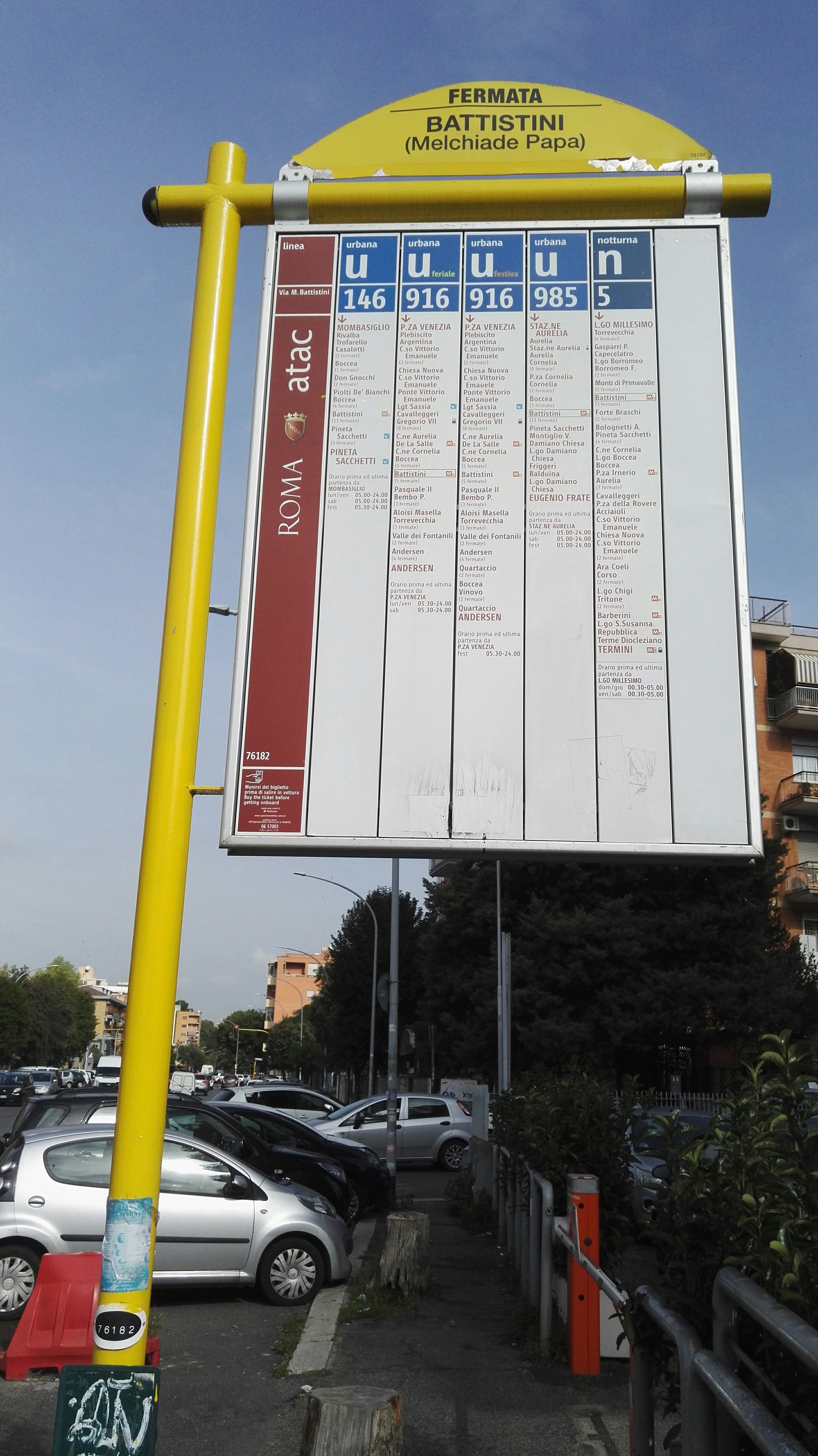 Taken by daliuto
See Battistini/Melchiade Papa stop, Roma, on the map
Public transit to Battistini/Melchiade Papa stop (ID: 76182) in Roma
Looking for directions to Battistini/Melchiade Papa in Roma, Italy?
Download the Moovit App to find the current schedule and step-by-step directions for Bus, Metro or Train routes that pass through Battistini/Melchiade Papa.
Looking for the nearest stops closest to Battistini/Melchiade Papa ? Check out this list of closest stops to your destination: Borromeo F./Clemente XI; Pasquale II/Clement XI; Primavalle Hills/Mazzella; Pineta Sacchetti/Ventura; Battistini/Lucio II; Battistini; Roma Balduina.
Bus: 146, 916, 985, 46, N46, 49, 907, 907L, 46B, 916F, 983, NMA, 446, 980, C6.Train: FL3.Metro: A.
We make riding on public transit to Battistini/Melchiade Papa easy, which is why over 1.7 billion users, including users in Roma trust Moovit as the best app for public transit.
Use the app to navigate to popular places including to the airport, hospital, stadium, grocery store, mall, coffee shop, school, college, and university.
Battistini/Melchiade Papa stop’s code is 76182
The first line to this stop is N46, at 3:07 AM, and the last line is N46 at 2:47 AM.
64 Via San Melchiade Papa, Roma, Italy
This stop serves ATAC and BIS’s lines
Popular routes from Battistini/Melchiade Papa stop, Roma
- Borromeo F./Clemente XI,
- Pasquale II/Clement XI,
- Primavalle Hills/Mazzella,
- Pineta Sacchetti/Ventura,
- Battistini/Lucio II
Bus stops near Battistini/Melchiade Papa stop
- Battistini
Metro station near Battistini/Melchiade Papa station
- Roma Balduina
Train station near Battistini/Melchiade Papa station
- Val Di Lanzo,
- Dell'Omo/Piccola Lourdes,
- Tiburtina/Bargellini,
- Via Nomentana (Twelve Apostles) - Fonte Nuova,
- Due Leoni-Fontana Candida,
- Porta Maggiore Street,
- Pomezia | Lake Maggiore Street Po Avenue,
- Saxa Rubra Station,
- Pontinia | Via Appia (Mesa),
- Pullino-Garbatella (Metro B),
- Trieste/Trento,
- Prenestina/Tor Tre Teste,
- Pasquale II/Clement XI,
- Monte Del Gallo (Station),
- Rome Termini Station (Giolitti),
- Leonardo Park,
- Sperlonga | Lepanto Street,
- Gregory VII/Satolli,
- Colleferro | Via Casilina (Depot),
- Rivisondoli
Popular public transit stations in Roma
Get around Roma by public transit!
Traveling around Roma has never been so easy. See step by step directions as you travel to any attraction, street or major public transit station. View bus and train schedules, arrival times, service alerts and detailed routes on a map, so you know exactly how to get to anywhere in Roma.
When traveling to any destination around Roma use Moovit's Live Directions with Get Off Notifications to know exactly where and how far to walk, how long to wait for your line, and how many stops are left. Moovit will alert you when it's time to get off — no need to constantly re-check whether yours is the next stop.
Wondering how to use public transit in Roma or how to pay for public transit in Roma? Moovit public transit app can help you navigate your way with public transit easily, and at minimum cost. It includes public transit fees, ticket prices, and costs. Looking for a map of Roma public transit lines? Moovit public transit app shows all public transit maps in Roma with all Bus, Train, Metro, Light Rail, Ferry, Funicular and Gondola routes and stops on an interactive map.
Rome and Lazio has 7 transit type(s), including: Bus, Train, Metro, Light Rail, Ferry, Funicular and Gondola, operated by several transit agencies, including ATAC, Cotral, Trenitalia, Troiani Transportation Services, BIS, ATR Mobility, Tuscia, Shuttle, Seatour, Troiani Bus Lines, CSC Mobility, Terravision, ATRAL, Tambus and Sitbus