Belli station - Tuesday schedule
| Line | Direction | Time |
|---|---|---|
| 8 | Casaletto | 5:40 AM |
| 8 | Casaletto | 5:46 AM |
| 8 | Casaletto | 5:54 AM |
| 8 | Casaletto | 6:03 AM |
| 8 | Casaletto | 6:12 AM |
| 8 | Casaletto | 6:21 AM |
| 8 | Casaletto | 6:31 AM |
| 8 | Casaletto | 6:40 AM |
| 8 | Casaletto | 6:49 AM |
| 8 | Casaletto | 6:57 AM |
| 8 | Casaletto | 7:05 AM |
| 8 | Casaletto | 7:10 AM |
| 8 | Casaletto | 7:14 AM |
| 8 | Casaletto | 7:19 AM |
| 8 | Casaletto | 7:23 AM |
| 8 | Casaletto | 7:27 AM |
| 8 | Casaletto | 7:31 AM |
| 8 | Casaletto | 7:35 AM |
| 8 | Casaletto | 7:39 AM |
| 8 | Casaletto | 7:42 AM |
| 8 | Casaletto | 7:47 AM |
| 8 | Casaletto | 7:56 AM |
| 8 | Casaletto | 8:04 AM |
| 8 | Casaletto | 8:12 AM |
| 8 | Casaletto | 8:20 AM |
Directions to Belli station (Roma) with public transit
The following transit lines have routes that pass near Belli
 Bus: 280, 8BUS, H, 8, N3D.
- Train: FC2, FL1, FL3, FL5.
- Metro: B.
- Light Rail: 8.
How to get to Belli station by bus?
Click on the bus route to see step by step directions with maps, line arrival times and updated time schedules.
How to get to Belli station by train?
Click on the train route to see step by step directions with maps, line arrival times and updated time schedules.
How to get to Belli station by metro?
Click on the metro route to see step by step directions with maps, line arrival times and updated time schedules.
Bus stops near Belli stop in Roma
- Belli, 1 min walk,
- Gioacchino Belli, 1 min walk,
- Sonnino/San Gallicano (Hospital), 1 min walk,
- Sanzio Waterfront/Filipperi, 2 min walk,
- Lungotevere De' Cenci/Arenula, 4 min walk,
Light Rail stations near Belli station in Roma
- Trastevere/Ministry of Education, 2 min walk,
Bus lines to Belli station in Roma
- 8, Casaletto,
- 8BUS, Astalli/Venezia,
- H, Dei Capasso,
- N3D, Piazzale Ostiense-Piramide (Metro B-Rail Line),
- N8, Termini (Metro A-Metro B-Railway),
- N3S, Ostiense Square-Pyramid (Metro-Rail),
- 23, Clodio,
- 280, Mancini,
- 63, Monte Savello Square (H),
What are the closest stations to Belli?
The closest stations to Belli are:
- Belli stop is 20 meters away, 1 min walk.
- Gioacchino Belli stop is 40 meters away, 1 min walk.
- Sonnino/San Gallicano (Hospital) stop is 49 meters away, 1 min walk.
- Sanzio Waterfront/Filipperi stop is 98 meters away, 2 min walk.
- Trastevere/Ministry of Education station is 106 meters away, 2 min walk.
- Lungotevere De' Cenci/Arenula stop is 249 meters away, 4 min walk.
Which bus lines stop near Belli?
These bus lines stop near Belli: 280, 8BUS, H.
Which train lines stop near Belli?
These train lines stop near Belli: FC2, FL1, FL3, FL5.
Which metro line stops near Belli?
B (Rebibbia/Jonio)
Which light rail line stops near Belli?
8 (Venice)
What’s the nearest light rail station to Belli in Roma?
The nearest light rail station to Belli in Roma is Trastevere/Ministry of Education. It’s a 2 min walk away.
What’s the nearest bus station to Belli in Roma?
The nearest bus stations to Belli in Roma are Belli, Gioacchino Belli and Sonnino/San Gallicano (Hospital). The closest one is a 1 min walk away.
What time is the first light rail to Belli in Roma?
The 8 is the first light rail that goes to Belli in Roma. It stops nearby at 5:26 AM.
What time is the last light rail to Belli in Roma?
The 8 is the last light rail that goes to Belli in Roma. It stops nearby at 8:37 PM.
What time is the first bus to Belli in Roma?
The N3S is the first bus that goes to Belli in Roma. It stops nearby at 3:02 AM.
What time is the last bus to Belli in Roma?
The N3S is the last bus that goes to Belli in Roma. It stops nearby at 3:28 AM.
Belli station
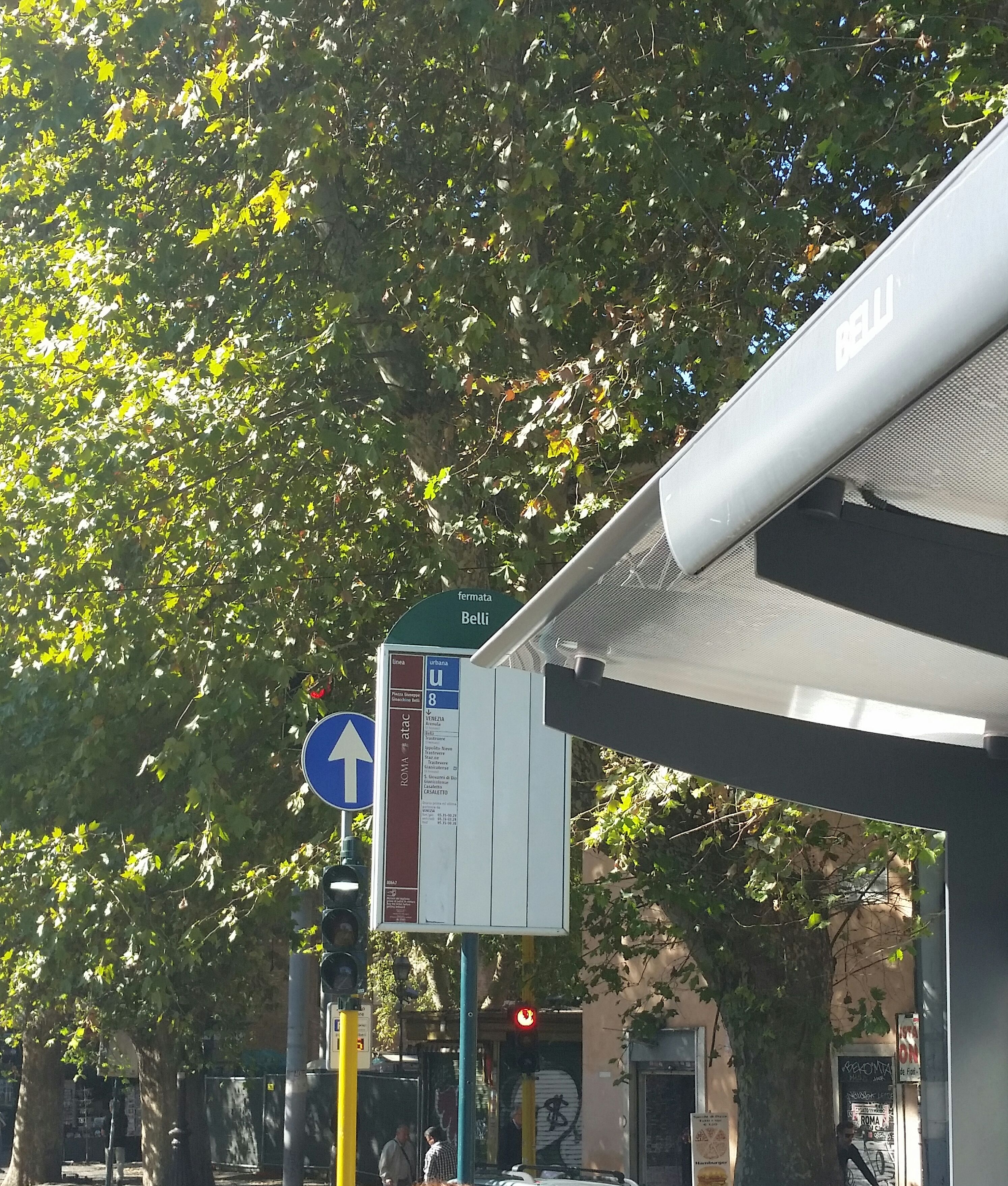 Taken by Anonymous
See Belli station, Roma, on the map
Public transit to Belli station (ID: 80647) in Roma
Looking for directions to Belli in Roma, Italy?
Download the Moovit App to find the current schedule and step-by-step directions for Bus, Train, Metro or Light Rail routes that pass through Belli.
Looking for the nearest stops closest to Belli ? Check out this list of closest stops to your destination: Belli; Gioacchino Belli; Sonnino/San Gallicano (Hospital); Sanzio Waterfront/Filipperi; Trastevere/Ministry of Education; Lungotevere De' Cenci/Arenula.
Bus: 280, 8BUS, H, 8, N3D, N8, N3S, 23, 63.Train: FC2, FL1, FL3, FL5.Metro: B.Light Rail: 8.
We make riding on public transit to Belli easy, which is why over 1.7 billion users, including users in Roma trust Moovit as the best app for public transit.
Use the app to navigate to popular places including to the airport, hospital, stadium, grocery store, mall, coffee shop, school, college, and university.
Belli station’s code is 80647
The first line to this station is 8, at 5:40 AM, and the last line is 8 at 7:36 PM.
9F Piazza Giuseppe Gioachino Belli, Roma, Italy
This station serves ATAC’s lines
- Belli,
- Gioacchino Belli,
- Sonnino/San Gallicano (Hospital),
- Sanzio Waterfront/Filipperi,
- Lungotevere De' Cenci/Arenula
Bus stops near Belli stop
- Trastevere/Ministry of Education
Light Rail station near Belli station
- Marechiaro,
- Poggio S. Lorenzo | Fp001 Fermata Provvisoria,
- Casilina/Pierozzi,
- Vittorio Emanuele Course/Navona,
- Agriculture,
- Alessandro Magno/Casal Palocco,
- Ponza,
- Ciciliano,
- Valle Aurelia,
- Volturno/Gaeta,
- Meda (Mb),
- Plebiscite Square,
- Portonaccio/Arimondi,
- Lucio Sestio (MA),
- Colli Portuensi/Fermi C.,
- Poggio Moiano via Salaria (Osteria Nuova),
- Isole Curzolane/Capraia,
- Mazzini/Monte Grappa,
- Piazza Saxa Rubra,
- Anagnina/Sette Metri
Popular public transit stations in Roma
Get around Roma by public transit!
Traveling around Roma has never been so easy. See step by step directions as you travel to any attraction, street or major public transit station. View bus and train schedules, arrival times, service alerts and detailed routes on a map, so you know exactly how to get to anywhere in Roma.
When traveling to any destination around Roma use Moovit's Live Directions with Get Off Notifications to know exactly where and how far to walk, how long to wait for your line, and how many stops are left. Moovit will alert you when it's time to get off — no need to constantly re-check whether yours is the next stop.
Wondering how to use public transit in Roma or how to pay for public transit in Roma? Moovit public transit app can help you navigate your way with public transit easily, and at minimum cost. It includes public transit fees, ticket prices, and costs. Looking for a map of Roma public transit lines? Moovit public transit app shows all public transit maps in Roma with all Bus, Train, Metro, Light Rail, Ferry, Funicular and Gondola routes and stops on an interactive map.
Rome and Lazio has 7 transit type(s), including: Bus, Train, Metro, Light Rail, Ferry, Funicular and Gondola, operated by several transit agencies, including ATAC, Cotral, Trenitalia, Troiani Transportation Services, BIS, ATR Mobility, Tuscia, Shuttle, Seatour, Troiani Bus Lines, CSC Mobility, Terravision, ATRAL, Tambus and Sitbus