Bernstorffsvej St. station - Saturday schedule
| Line | Direction | Time |
|---|---|---|
| 920E | Hillerød | 04:07 |
| 920E | Hundested | 04:17 |
| 920E | Hillerød | 04:37 |
| 920E | Hundested | 04:47 |
| 920E | Hillerød | 05:07 |
| 920E | Hundested | 05:17 |
| 920E | Hillerød | 05:37 |
| 920E | Hundested | 05:47 |
| 920E | Hillerød | 06:07 |
| 920E | Hundested | 06:17 |
| 920E | Hillerød | 06:37 |
| 920E | Hundested | 06:47 |
| 920E | Hillerød | 06:57 |
| 920E | Hundested | 07:07 |
| 920E | Hillerød | 07:17 |
| 920E | Hundested | 07:27 |
| 920E | Hillerød | 07:37 |
| 920E | Hundested | 07:47 |
| 920E | Hillerød | 07:57 |
| 920E | Hundested | 08:07 |
| 920E | Hillerød | 08:17 |
| 920E | Hundested | 08:27 |
| 920E | Hillerød | 08:37 |
| 920E | Hundested | 08:47 |
| 920E | Hillerød | 08:57 |
See Bernstorffsvej St., Gentofte, on the map
Directions to Bernstorffsvej St. (Gentofte) with public transportation
The following transit lines have routes that pass near Bernstorffsvej St.
 Bus:
Bus: - Train:
How to get to Bernstorffsvej St. by bus?
Click on the bus route to see step by step directions with maps, line arrival times and updated time schedules.
How to get to Bernstorffsvej St. by train?
Click on the train route to see step by step directions with maps, line arrival times and updated time schedules.
Bus stations near Bernstorffsvej St. in Gentofte
- Bernstorffsvej St. (Tranegårdsvej),1 min walk,
- Bernstorffsvej St. (Bernstorffsvej),4 min walk,
- Tranegårdsvej (Hartmannsvej),10 min walk,
Train stations near Bernstorffsvej St. in Gentofte
- Charlottenlund St.,7 min walk,
- Dyssegård St.,15 min walk,
- Gentofte St.,25 min walk,
- Hellerup St.,38 min walk,
Bus lines to Bernstorffsvej St. in Gentofte
- 176,Emdrup Torv,
- 185,Klampenborg St.,
- 192,Charlottenlund Fort,
What are the closest stations to Bernstorffsvej St.?
The closest stations to Bernstorffsvej St. are:
- Bernstorffsvej St. (Tranegårdsvej) is 58 meters away, 1 min walk.
- Bernstorffsvej St. (Bernstorffsvej) is 248 meters away, 4 min walk.
- Charlottenlund St. is 464 meters away, 7 min walk.
- Tranegårdsvej (Hartmannsvej) is 731 meters away, 10 min walk.
- Dyssegård St. is 1177 meters away, 15 min walk.
- Gentofte St. is 1918 meters away, 25 min walk.
- Hellerup St. is 2957 meters away, 38 min walk.
Which bus lines stop near Bernstorffsvej St.?
These bus lines stop near Bernstorffsvej St.: 176, 185.
Which train line stops near Bernstorffsvej St.?
E
What’s the nearest train station to Bernstorffsvej St. in Gentofte?
The nearest train station to Bernstorffsvej St. in Gentofte is Charlottenlund St.. It’s a 7 min walk away.
What’s the nearest bus stop to Bernstorffsvej St. in Gentofte?
The nearest bus stop to Bernstorffsvej St. in Gentofte is Bernstorffsvej St. (Tranegårdsvej). It’s a 1 min walk away.
What time is the first train to Bernstorffsvej St. in Gentofte?
The RE is the first train that goes to Bernstorffsvej St. in Gentofte. It stops nearby at 4:58 AM.
What time is the last train to Bernstorffsvej St. in Gentofte?
The F is the last train that goes to Bernstorffsvej St. in Gentofte. It stops nearby at 1:04 AM.
What time is the first bus to Bernstorffsvej St. in Gentofte?
The 185 is the first bus that goes to Bernstorffsvej St. in Gentofte. It stops nearby at 5:28 AM.
What time is the last bus to Bernstorffsvej St. in Gentofte?
The 185 is the last bus that goes to Bernstorffsvej St. in Gentofte. It stops nearby at 12:16 AM.
See Bernstorffsvej St., Gentofte, on the map
Public transit to Bernstorffsvej St. station in Gentofte
Looking for directions to Bernstorffsvej St. in Gentofte, Denmark?
Download the Moovit App to find the current schedule and step-by-step directions for Train, Bus or Metro routes that pass through Bernstorffsvej St..
Looking for the nearest stops closest to Bernstorffsvej St. ? Check out this list of closest stops to your destination: Bernstorffsvej St. (Tranegårdsvej); Bernstorffsvej St. (Bernstorffsvej); Charlottenlund St.; Tranegårdsvej (Hartmannsvej); Dyssegård St.; Gentofte St.; Hellerup St..
Bus:Train:
We make riding on public transit to Bernstorffsvej St. easy, which is why over 1.5 million users, including users in Gentofte trust Moovit as the best app for public transit.
Use the app to navigate to popular places including to the airport, hospital, stadium, grocery store, mall, coffee shop, school, college, and university.
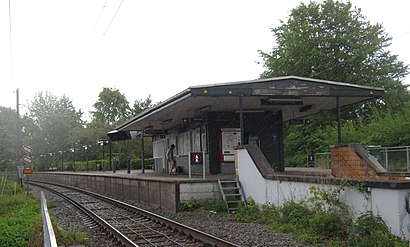
The station has the following entrances: Tranegårdsvej and Bernstorffsvej
The first line to this station is 920E, at 04:07, and the last line is 920E at 03:47.
Bernstorffsvej 134, Copenhagen, Denmark
This station serves DSB S-tog and Lokaltog A/S’s lines
Popular routes from Bernstorffsvej St., Gentofte
Bus stops near Bernstorffsvej St.
Bernstorffsvej St. (Tranegårdsvej),Bernstorffsvej St. (Bernstorffsvej),Tranegårdsvej (Hartmannsvej)Popular public transit stations in Gentofte
Sluseholmen (Sjællandsbroen),Vallensbækvej (Søndre Ringvej),Legoland / Lalandia (Billund),Odd Fellow Palæet (Dronningens Tværgade),Rørkær (Tønder),Marienlyst St.,Frydenlunds Allé/Viborgvej (Aarhus Kom),Frederiksberg Allé St. (Metro),De Små Haver (Roskildevej),Hjørring Sygehus (Vendsyssel / Bispensgade),Strandvejen (Hellerupvej),Dyrskuepladsen (Tingstrupvej / Thisted),Dalumcentret (Odense Kommune),Skovbrynet (Kongevejen),Finlandsvej V Boråsvej (Vejle),Svanemøllen St.,Ålholm Plads (Roskildevej),Teglholm Allé (Teglholmsgade),Østergade/Chr. 8.S Vej (Silkeborg Kom),Charlottenlund Fort (Strandvejen)Get around Gentofte by public transit!
Traveling around Gentofte has never been so easy. See step by step directions as you travel to any attraction, street or major public transit station. View bus and train schedules, arrival times, service alerts and detailed routes on a map, so you know exactly how to get to anywhere in Gentofte.
When traveling to any destination around Gentofte use Moovit's Live Directions with Get Off Notifications to know exactly where and how far to walk, how long to wait for your line, and how many stops are left. Moovit will alert you when it's time to get off — no need to constantly re-check whether yours is the next stop.
Wondering how to use public transit in Gentofte or how to pay for public transit in Gentofte? Moovit public transit app can help you navigate your way with public transit easily, and at minimum cost. It includes public transit fees, ticket prices, and costs. Looking for a map of Gentofte public transit lines? Moovit public transit app shows all public transit maps in Gentofte with all train, bus or metro routes and stops on an interactive map.
Gentofte has 3 transit type(s), including: train, bus or metro, operated by several transit agencies, including Metroselskabet, DSB S-tog, Lokaltog A/S, DSB S-tog, Midttrafik, Odense Letbane, DSB, NT, GoCollective, Midttrafik, Skånetrafiken, Metroselskabet, Movia, NT and Midttrafik