How to get to Biyerr by bus?
Click on the bus route to see step by step directions with maps, line arrival times and updated time schedules.
From Beşyol, Selçuklu
45 minFrom Zafer Çarşısı, Selçuklu
50 minFrom Konya/Özalkent, Selçuklu
33 minFrom Konya Organize Sanayi Bölgesi, Selçuklu
93 minFrom Karatay TOKİ Anadolu Lisesi, Selçuklu
75 minFrom 31 nolu mengene saraçoğlu otobüsü, Selçuklu
61 minFrom Konya, Selçuklu
48 minFrom Otogar Aydınlık Dolmuşu, Selçuklu
28 minFrom Muhacir Pazarı, Selçuklu
57 minFrom Konya Karatay Şehir Parkı Lunapark, Selçuklu
93 min
Bus stops near Biyerr in Selçuklu
Light Rail stations near Biyerr in Selçuklu
- Medaş (T12), 13 min walk,VIEW
Bus lines to Biyerr in Selçuklu
What are the closest stations to Biyerr?
The closest stations to Biyerr are:
- Öztekinler is 136 meters away, 2 min walk.
- Şehit Ali Vasfi Güney is 285 meters away, 4 min walk.
- Toros is 432 meters away, 6 min walk.
- Saray Bosna is 514 meters away, 7 min walk.
- Yıldırım Beyazıt Cami is 608 meters away, 8 min walk.
- Medaş (T12) is 953 meters away, 13 min walk.
Which bus lines stop near Biyerr?
These bus lines stop near Biyerr: 102-A, 86-A.
Which light rail line stops near Biyerr?
150-A (Selçuk Üniversitesi)
What’s the nearest light rail station to Biyerr in Selçuklu?
The nearest light rail station to Biyerr in Selçuklu is Medaş (T12). It’s a 13 min walk away.
What’s the nearest bus station to Biyerr in Selçuklu?
The nearest bus station to Biyerr in Selçuklu is Öztekinler. It’s a 2 min walk away.
What time is the first light rail to Biyerr in Selçuklu?
The 153-A is the first light rail that goes to Biyerr in Selçuklu. It stops nearby at 3:34 AM.
What time is the last light rail to Biyerr in Selçuklu?
The 153-A is the last light rail that goes to Biyerr in Selçuklu. It stops nearby at 2:03 AM.
What time is the first bus to Biyerr in Selçuklu?
The 58-A is the first bus that goes to Biyerr in Selçuklu. It stops nearby at 6:02 AM.
What time is the last bus to Biyerr in Selçuklu?
The 60-A is the last bus that goes to Biyerr in Selçuklu. It stops nearby at 12:19 AM.
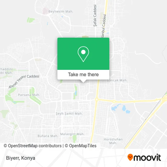
See Biyerr, Selçuklu, on the map
Public Transit to Biyerr in Selçuklu
Wondering how to get to Biyerr in Selçuklu? Moovit helps you find the best way to get to Biyerr with step-by-step directions from the nearest public transit station.
Moovit provides free maps and live directions to help you navigate through your city. View schedules, routes, timetables, and find out how long does it take to get to Biyerr in real time.
Looking for the nearest stop or station to Biyerr? Check out this list of stops closest to your destination: Öztekinler; Şehit Ali Vasfi Güney; Toros; Saray Bosna; Yıldırım Beyazıt Cami; Medaş (T12).
Bus: 102-A, 86-A, 60-A, 101-A, 104-A, 104-B, 104-C, 58-A, 49-A.Light Rail: 150-A.
Want to see if there’s another route that gets you there at an earlier time? Moovit helps you find alternative routes or times. Get directions from and directions to Biyerr easily from the Moovit App or Website.
We make riding to Biyerr easy, which is why over 1.5 million users, including users in Selçuklu, trust Moovit as the best app for public transit. You don’t need to download an individual bus app or train app, Moovit is your all-in-one transit app that helps you find the best bus time or train time available.
For information on prices of bus and light rail, costs and ride fares to Biyerr, please check the Moovit app.
Use the app to navigate to popular places including to the airport, hospital, stadium, grocery store, mall, coffee shop, school, college, and university.
Biyerr Address: Yazır Mah. Öztekinler Sk. No:6/A street in Selçuklu
- Fulya Konutları,
- Konya Üniversitesi,
- Yeşilkent Sitesi,
- İnci Kitabevi,
- Todem Yeşilkent Konutları,
- Selçuklu Cahit Zarifoğlu Ilkokulu,
- Elmacı Almira Park,
- Selçuk42hause,
- Saray Masaj Spa,
- Erguvan Gençlik ve Spor Kulübü Derneği,
- Ebrar Cafe Pasta,
- PTT-Otogar,
- Otogar Büfe (Otogar Market),
- Seyet Et,
- Otağ Kitabevi Selçuklu,
- 34 İstanbul Züccaciye,
- Torku Doğrudan Gıda Market,
- Çankaya Çubuk Turşuları & Çiğ Köfte Evi,
- Beyaz Saray Sitesi,
- Nida Kuaför
Places Near Biyerr (Selçuklu)
- Selçuklu Kongre Merkezi, Selçuklu,
- Otogar Aydınlık Dolmuşu, Selçuklu,
- Konya Yüksek Hızlı Tren Garı (Konya YHT Garı), Selçuklu,
- Konya Havalimanı, Selçuklu,
- Adliye Sancak Dolmuşu, Selçuklu,
- Konya Real Avm, Selçuklu,
- Kelebekler Vadisi, Selçuklu,
- Fatih Işıklar - Özalkent Dolmuşu, Selçuklu,
- Selçuklu Nüfus Müdürlüğü, Selçuklu,
- Konya Beyhekim Devlet Hastanesi, Selçuklu,
- Konya Tren Garı, Selçuklu,
- Meram Tıp Fakültesi, Meram,
- Bosna Hersek Mh Mutlu Son Masaj Salonu, Selçuklu,
- Kent Plaza (Konya Kent Plaza Alisveris Merkezi), Selçuklu,
- Kerhâne, Selçuklu,
- Büsan Sanayi, Selçuklu,
- Konya Otogar, Selçuklu,
- Bosna Kampüs Dolmuş Duragı, Selçuklu,
- Konya YHT Garı, Selçuklu,
- Konya Şehir Hastanesi, Selçuklu
How to get to popular places in Konya with public transit
Get around Selçuklu by public transit!
Traveling around Selçuklu has never been so easy. See step by step directions as you travel to any attraction, street or major public transit station. View bus and train schedules, arrival times, service alerts and detailed routes on a map, so you know exactly how to get to anywhere in Selçuklu.
When traveling to any destination around Selçuklu use Moovit's Live Directions with Get Off Notifications to know exactly where and how far to walk, how long to wait for your line, and how many stops are left. Moovit will alert you when it's time to get off — no need to constantly re-check whether yours is the next stop.
Wondering how to use public transit in Selçuklu or how to pay for public transit in Selçuklu? Moovit public transit app can help you navigate your way with public transit easily, and at minimum cost. It includes public transit fees, ticket prices, and costs. Looking for a map of Selçuklu public transit lines? Moovit public transit app shows all public transit maps in Selçuklu with all Bus and Light Rail routes and stops on an interactive map.
Konya has 2 transit type(s), including: Bus and Light Rail, operated by several transit agencies, including ATUS and Havaş