How to get to Bogenplatz by bus?
Click on the bus route to see step by step directions with maps, line arrival times and updated time schedules.
From Kaufland Geislingen, Vereinbarte Verwaltungsgemeinschaft Der Stadt Geislingen An Der Steige
116 minFrom Ostalb-Klinikum, Verwaltungsgemeinschaft Aalen
89 minFrom Amazon-DBX8, Herbrechtingen
73 minFrom Justus-Von-Liebig-Schule Aalen, Verwaltungsgemeinschaft Aalen
97 minFrom Kinopark Aalen, Verwaltungsgemeinschaft Aalen
88 minFrom Limes Thermen Aalen, Verwaltungsgemeinschaft Aalen
87 minFrom Gewerbliche Schule, Verwaltungsgemeinschaft Schwäbisch Gmünd
129 minFrom Bucher Stausee, Verwaltungsgemeinschaft Ellwangen (Jagst)
211 min
How to get to Bogenplatz by train?
Click on the train route to see step by step directions with maps, line arrival times and updated time schedules.
Bus stops near Bogenplatz in Heidenheim An Der Brenz
Train stations near Bogenplatz in Heidenheim An Der Brenz
Bus lines to Bogenplatz in Heidenheim An Der Brenz
What are the closest stations to Bogenplatz?
The closest stations to Bogenplatz are:
- Mergelstetten Sparkasse Bstg 2 is 185 meters away, 3 min walk.
- Mergelstetten Sparkasse Bstg 1 is 191 meters away, 3 min walk.
- Mergelstetten Tübinger Platz Bstg 2 is 279 meters away, 4 min walk.
- Hdh-Voithwerk is 2112 meters away, 28 min walk.
- Heidenheim Voithwerk is 2115 meters away, 27 min walk.
Which train lines stop near Bogenplatz?
These train lines stop near Bogenplatz: RE50, RS 5.
Which bus lines stop near Bogenplatz?
These bus lines stop near Bogenplatz: 35, 40, 5, 6.
What’s the nearest train station to Bogenplatz in Heidenheim An Der Brenz?
The nearest train station to Bogenplatz in Heidenheim An Der Brenz is Hdh-Voithwerk. It’s a 28 min walk away.
What’s the nearest bus station to Bogenplatz in Heidenheim An Der Brenz?
The nearest bus stations to Bogenplatz in Heidenheim An Der Brenz are Mergelstetten Sparkasse Bstg 2 and Mergelstetten Sparkasse Bstg 1. The closest one is a 3 min walk away.
What time is the first train to Bogenplatz in Heidenheim An Der Brenz?
The RE 50 is the first train that goes to Bogenplatz in Heidenheim An Der Brenz. It stops nearby at 5:13 AM.
What time is the last train to Bogenplatz in Heidenheim An Der Brenz?
The RS 51 is the last train that goes to Bogenplatz in Heidenheim An Der Brenz. It stops nearby at 5:34 PM.
What time is the first bus to Bogenplatz in Heidenheim An Der Brenz?
The 7 is the first bus that goes to Bogenplatz in Heidenheim An Der Brenz. It stops nearby at 5:56 AM.
What time is the last bus to Bogenplatz in Heidenheim An Der Brenz?
The 6 is the last bus that goes to Bogenplatz in Heidenheim An Der Brenz. It stops nearby at 10:29 PM.
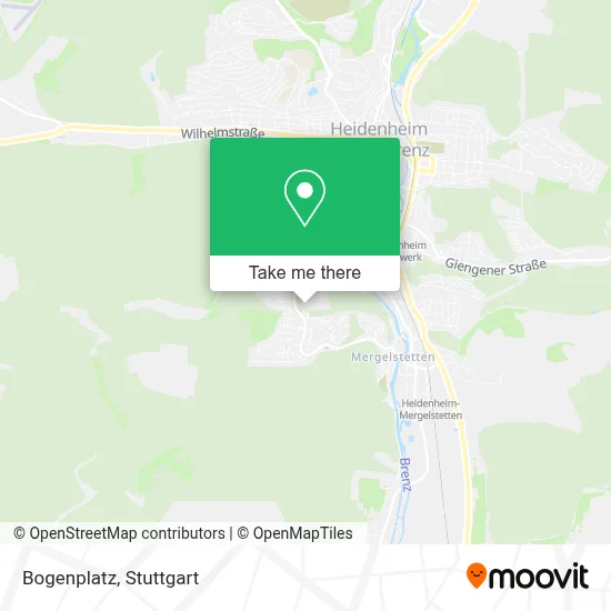
See Bogenplatz, Heidenheim An Der Brenz, on the map
Public Transit to Bogenplatz in Heidenheim An Der Brenz
Wondering how to get to Bogenplatz in Heidenheim An Der Brenz? Moovit helps you find the best way to get to Bogenplatz with step-by-step directions from the nearest public transit station.
Moovit provides free maps and live directions to help you navigate through your city. View schedules, routes, timetables, and find out how long does it take to get to Bogenplatz in real time.
Looking for the nearest stop or station to Bogenplatz? Check out this list of stops closest to your destination: Mergelstetten Sparkasse Bstg 2; Mergelstetten Sparkasse Bstg 1; Mergelstetten Tübinger Platz Bstg 2; Hdh-Voithwerk; Heidenheim Voithwerk.
Train: RE50, RS 5, RS5, RS51, RE 50, RS 51.Bus: 35, 40, 5, 6, 7, 6A.
Want to see if there’s another route that gets you there at an earlier time? Moovit helps you find alternative routes or times. Get directions from and directions to Bogenplatz easily from the Moovit App or Website.
We make riding to Bogenplatz easy, which is why over 1.5 million users, including users in Heidenheim An Der Brenz, trust Moovit as the best app for public transit. You don’t need to download an individual bus app or train app, Moovit is your all-in-one transit app that helps you find the best bus time or train time available.
For information on prices of bus and train, costs and ride fares to Bogenplatz, please check the Moovit app.
Use the app to navigate to popular places including to the airport, hospital, stadium, grocery store, mall, coffee shop, school, college, and university.
Bogenplatz Address: In der Schwende street in Heidenheim An Der Brenz
- Netto Filiale,
- Bogenplatz SV Mergelstetten,
- Handwerksbäckerei Mack,
- Bäckerei Mack,
- Sportvereinszentrum,
- Reutenenhalle,
- Sv Mergelstetten,
- Svm Gaststätte,
- Mergelstetten Heilbronner Straße,
- Grundschule Reutenen,
- Ökumenisches Haus Reutenen,
- Städt. Kindergarten Reuknen,
- Kreissparkasse Hdh,
- Petra Willert Dr.Med.Dent. Zahnärztin,
- Spielplatz Grundschule,
- Mergelstetten Sparkasse,
- Mergelstetten, Tübinger Platz,
- Claudia Packeiser - Dienstleistungen,
- Tübinger Platz,
- Nailstudio by Ar
Places Near Bogenplatz (Heidenheim An Der Brenz)
- FlixBus Haltestelle, Stuttgart,
- SI-Centrum, Möhringen,
- Waldfriedhof, Degerloch,
- Hanns-Martin-Schleyer-Halle, Bad Cannstatt,
- Pariser Platz Stuttgart, Stuttgart-Mitte,
- Hauptbahnhof Stuttgart, Stuttgart-Mitte,
- Mercedes-Benz Museum (Mercedes Museum Stuttgart), Bad Cannstatt,
- Porsche Museum, Zuffenhausen,
- Schleyerhalle, Bad Cannstatt,
- Gleis 101/102 (tief), Stuttgart-Mitte,
- Mercedes-Benz Museum, Bad Cannstatt,
- Gasometer Pforzheim, Pforzheim,
- Hanns-Martin-Schleyer-Halle (Stuttgart Hans-Martin-Schleyerhalle), Bad Cannstatt,
- Wilhelma (U-Bahn Wilhelma), Bad Cannstatt,
- Mettingen Eros-Center Puff Laufhaus, Esslingen Am Neckar,
- Klinikum Stuttgart - Katharinenhospital, Stuttgart-Mitte,
- Im Wizemann (Halle), Bad Cannstatt,
- Marmorsaal Im Weissenburgpark, Stuttgart-Süd,
- Geilhaus Haus 33a, Reutlingen-Betzingen,
- Porsche-Arena, Bad Cannstatt
How to get to popular places in Stuttgart with public transit
Get around Heidenheim An Der Brenz by public transit!
Traveling around Heidenheim An Der Brenz has never been so easy. See step by step directions as you travel to any attraction, street or major public transit station. View bus and train schedules, arrival times, service alerts and detailed routes on a map, so you know exactly how to get to anywhere in Heidenheim An Der Brenz.
When traveling to any destination around Heidenheim An Der Brenz use Moovit's Live Directions with Get Off Notifications to know exactly where and how far to walk, how long to wait for your line, and how many stops are left. Moovit will alert you when it's time to get off — no need to constantly re-check whether yours is the next stop.
Wondering how to use public transit in Heidenheim An Der Brenz or how to pay for public transit in Heidenheim An Der Brenz? Moovit public transit app can help you navigate your way with public transit easily, and at minimum cost. It includes public transit fees, ticket prices, and costs. Looking for a map of Heidenheim An Der Brenz public transit lines? Moovit public transit app shows all public transit maps in Heidenheim An Der Brenz with all Bus, Train, Subway, Light Rail, Ferry, S-Bahn and Funicular routes and stops on an interactive map.
Stuttgart has 7 transit type(s), including: Bus, Train, Subway, Light Rail, Ferry, S-Bahn and Funicular, operated by several transit agencies, including SSB - Stadtbahn, SSB, SSB - Seilbahn / Zacke, S-Bahn Stuttgart, Rhein-Neckar-Verkehr GmbH (rnv), Karlsruher Verkehrsverbund, DB AG, DB Regiobus BW, Arverio Baden-Württemberg GmbH, DB RegioNetz Verkehrs GmbH Westfrankenbahn, DB Regio AG Baden-Württemberg, Südwestdeutsche Verkehrs-AG, DB Regio AG Mitte Region Hessen, DB and Bodensee-Oberschwaben-Bahn