How to get to Bonny Bar by bus?
Click on the bus route to see step by step directions with maps, line arrival times and updated time schedules.
From Cinquale, Montignoso
112 minFrom Torre del Lago Puccini, Viareggio
48 minFrom Villa Bertelli, Union of Municipalities of Versilia
95 minFrom Marina di Pietrasanta, Pietrasanta
22 minFrom M.D. Barbantini Care Home, Viareggio
83 minFrom Pietrasanta Athletics Field - Falcone and Borsellino Facility, Pietrasanta
41 minFrom Le Dune Free Beach, Forte Dei Marmi
105 minFrom Arena of Versilia, Montignoso
61 minFrom San Camillo Care Home, Forte Dei Marmi
91 minFrom Tonfano, Union of Municipalities of Versilia
24 min
How to get to Bonny Bar by train?
Click on the train route to see step by step directions with maps, line arrival times and updated time schedules.
Bus stops near Bonny Bar in Viareggio
Train station near Bonny Bar in Viareggio
- Viareggio, 16 min walk,VIEW
Bus lines to Bonny Bar in Viareggio
- 25, Versilia Hospital,VIEW
- 27, Viareggio D'Azeglio Square,VIEW
- 33, Marco Polo Street Cemetery,VIEW
- E27, Viareggio D'Azeglio Square,VIEW
- E2, Romboni Square,VIEW
- E28, Viareggio D'Azeglio Square,VIEW
- E1, Lucca-A11-Viareggio-Forte Dei Marmi-Marina Di Massa Hospital,VIEW
- 21, Goretti-Aurelia Cemetery-Station-Garibaldi Post Office-San Francesco-Azeglio-Fattore-Coppino-Virgilio-Filzi,VIEW
- E26, Pietrasanta-Viareggio-Massarosa,VIEW
What are the closest stations to Bonny Bar?
The closest stations to Bonny Bar are:
- Fratti Street is 147 meters away, 3 min walk.
- Marco Polo Street Cemetery is 256 meters away, 4 min walk.
- Buonarroti Avenue Marco Polo Street Junction is 486 meters away, 7 min walk.
- Via Aurelia - Cemetery is 525 meters away, 7 min walk.
- Viareggio is 1176 meters away, 16 min walk.
Which bus lines stop near Bonny Bar?
These bus lines stop near Bonny Bar: 25, E1, E25, E26.
Which train line stops near Bonny Bar?
R (Genova/La Spezia)
What’s the nearest train station to Bonny Bar in Viareggio?
The nearest train station to Bonny Bar in Viareggio is Viareggio. It’s a 16 min walk away.
What’s the nearest bus station to Bonny Bar in Viareggio?
The nearest bus station to Bonny Bar in Viareggio is Fratti Street. It’s a 3 min walk away.
What time is the first train to Bonny Bar in Viareggio?
The R is the first train that goes to Bonny Bar in Viareggio. It stops nearby at 5:58 AM.
What time is the last train to Bonny Bar in Viareggio?
The R is the last train that goes to Bonny Bar in Viareggio. It stops nearby at 11:50 PM.
What time is the first bus to Bonny Bar in Viareggio?
The 25 is the first bus that goes to Bonny Bar in Viareggio. It stops nearby at 6:57 AM.
What time is the last bus to Bonny Bar in Viareggio?
The 25 is the last bus that goes to Bonny Bar in Viareggio. It stops nearby at 8:59 PM.
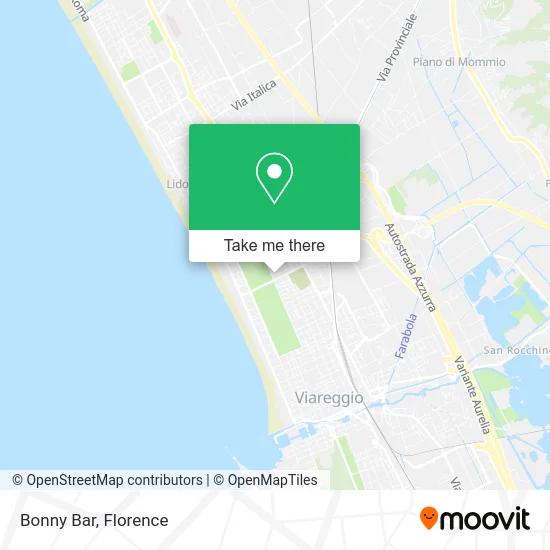
See Bonny Bar, Viareggio, on the map
Public Transit to Bonny Bar in Viareggio
Wondering how to get to Bonny Bar in Viareggio? Moovit helps you find the best way to get to Bonny Bar with step-by-step directions from the nearest public transit station.
Moovit provides free maps and live directions to help you navigate through your city. View schedules, routes, timetables, and find out how long does it take to get to Bonny Bar in real time.
Looking for the nearest stop or station to Bonny Bar? Check out this list of stops closest to your destination: Fratti Street; Marco Polo Street Cemetery; Buonarroti Avenue Marco Polo Street Junction; Via Aurelia - Cemetery; Viareggio.
Bus: 25, E1, E25, E26, 27, 33, E27, E2, E28, 21.Train: R.
Want to see if there’s another route that gets you there at an earlier time? Moovit helps you find alternative routes or times. Get directions from and directions to Bonny Bar easily from the Moovit App or Website.
We make riding to Bonny Bar easy, which is why over 1.5 million users, including users in Viareggio, trust Moovit as the best app for public transit. You don’t need to download an individual bus app or train app, Moovit is your all-in-one transit app that helps you find the best bus time or train time available.
For information on prices of bus and train, costs and ride fares to Bonny Bar, please check the Moovit app.
Use the app to navigate to popular places including to the airport, hospital, stadium, grocery store, mall, coffee shop, school, college, and university.
Bonny Bar Address: Via Giulio Cesare, 55049 Viareggio street in Viareggio
- Building House Simplified,
- Prisco Lawyer Umberto,
- The Mirror,
- Pezziebokkoni of Bamb,
- Exclusive Boutique,
- Post Office, Marco Polo Street,
- Lu.VI.,
- The Piazzone by Mister Via Fratti,
- Il Vagero Travel,
- Ramacciotti Giorgio,
- The Forte Banquet,
- Luigi Morelli Cooperative Handling Society,
- S.E.L.M. Systems,
- Slam,
- Marco Marconi,
- Vascoman Laundry,
- Apegreen Laundry Giustoprezzo by Landucci Maria Pia,
- Giampaolo Giudici,
- Versilia Opportunities by Katcheva Youliana,
- Red Bar Pastry Shop
Places Near Bonny Bar (Viareggio)
- Michelangelo Square, Florence,
- Michelangelo Square, Florence,
- Asmana, Campi Bisenzio,
- Artemio Franchi Municipal Stadium, Florence,
- Torregalli Hospital Scandicci *, Scandicci,
- Nelson Mandela Forum, Florence,
- Verdi Theater, Florence,
- Field of Mars, Florence,
- Santa Maria Nuova Hospital, Florence,
- Piero Palagi Hospital Facility-Florence, Florence,
- Mandela Forum (Nelson Mandela Forum), Florence,
- Campi Bisenzio, Campi Bisenzio,
- Santa Maria Novella Station, Florence,
- IKEA Florence, Sesto Fiorentino,
- OOO, Florence,
- Tobacco Manufacture, Florence,
- Viola Park, Bagno a Ripoli,
- Cascine Park, Florence,
- Wanny Palace, Florence,
- I Gigli, Campi Bisenzio
How to get to popular places in Florence with public transit
Get around Viareggio by public transit!
Traveling around Viareggio has never been so easy. See step by step directions as you travel to any attraction, street or major public transit station. View bus and train schedules, arrival times, service alerts and detailed routes on a map, so you know exactly how to get to anywhere in Viareggio.
When traveling to any destination around Viareggio use Moovit's Live Directions with Get Off Notifications to know exactly where and how far to walk, how long to wait for your line, and how many stops are left. Moovit will alert you when it's time to get off — no need to constantly re-check whether yours is the next stop.
Wondering how to use public transit in Viareggio or how to pay for public transit in Viareggio? Moovit public transit app can help you navigate your way with public transit easily, and at minimum cost. It includes public transit fees, ticket prices, and costs. Looking for a map of Viareggio public transit lines? Moovit public transit app shows all public transit maps in Viareggio with all Bus, Train, Light Rail, Ferry and Funicular routes and stops on an interactive map.
Florence has 5 transit type(s), including: Bus, Train, Light Rail, Ferry and Funicular, operated by several transit agencies, including Florence Urban - Tuscan Bus Lines, GEST, Florence and Province - Tuscan Bus Lines, Livorno and Province - Tuscan Bus Lines, Arezzo, Florence and Provinces - Tuscan Bus Lines, Prato and Province - Tuscan Bus Lines, Massa, Carrara and Province - Tuscan Bus Lines, Pisa and Province - Tuscan Bus Lines, Grosseto, Siena and Provinces - Tuscan Bus Lines, Arezzo, Siena and Provinces - Tuscan Bus Lines, Pistoia and Province - Tuscan Bus Lines, Siena and Province - Tuscan Bus Lines, Arezzo and Province - Tuscan Bus Lines, Lucca and Province - Tuscan Bus Lines and Trenitalia