Boston Rd @ Bivona St stop - Wednesday schedule
| Line | Direction | Time |
|---|---|---|
| 61 | Willet Ave @ Putnam Ave | 6:10 AM |
| 60 | White Plains Bus Terminal Lane B | 6:15 AM |
| BX30 | Co-Op City Earhart La Via Boston Rd | 6:17 AM |
| 60 | White Plains Bus Terminal Lane B | 6:30 AM |
| BX30 | Co-Op City Earhart La Via Boston Rd | 6:37 AM |
| 61 | Willet Ave @ Putnam Ave | 6:45 AM |
| 62 | Express - White Plains | 6:46 AM |
| BX30 | Co-Op City Earhart La Via Boston Rd | 6:47 AM |
| 60 | White Plains Bus Terminal Lane B | 6:55 AM |
| BX30 | Co-Op City Earhart La Via Boston Rd | 6:57 AM |
| BX30 | Co-Op City Earhart La Via Boston Rd | 7:05 AM |
| 60 | White Plains Bus Terminal Lane B | 7:07 AM |
| BX30 | Co-Op City Earhart La Via Boston Rd | 7:14 AM |
| 61 | Willet Ave @ Putnam Ave | 7:15 AM |
| 62 | White Plains Bus Terminal Lane B | 7:21 AM |
| 60 | White Plains Bus Terminal Lane B | 7:25 AM |
| BX30 | Co-Op City Earhart La Via Boston Rd | 7:27 AM |
| BX30 | Co-Op City Earhart La Via Boston Rd | 7:35 AM |
| 62 | White Plains Bus Terminal Lane B | 7:36 AM |
| 61 | Willet Ave @ Putnam Ave | 7:40 AM |
| BX30 | Co-Op City Earhart La Via Boston Rd | 7:43 AM |
| BX30 | Co-Op City Earhart La Via Boston Rd | 7:51 AM |
| BX30 | Co-Op City Earhart La Via Boston Rd | 7:59 AM |
| 62 | White Plains Bus Terminal Lane B | 8:01 AM |
| 60 | White Plains Bus Terminal Lane B | 8:02 AM |
Directions to Boston Rd @ Bivona St stop (Bronx) with public transit
The following transit lines have routes that pass near Boston Rd @ Bivona St
 Bus: 55, 60, 61, BX30, 52.
- Train: 2.
- Subway: 5, 2.
How to get to Boston Rd @ Bivona St stop by bus?
Click on the bus route to see step by step directions with maps, line arrival times and updated time schedules.
How to get to Boston Rd @ Bivona St stop by train?
Click on the train route to see step by step directions with maps, line arrival times and updated time schedules.
How to get to Boston Rd @ Bivona St stop by subway?
Click on the subway route to see step by step directions with maps, line arrival times and updated time schedules.
Bus stops near Boston Rd @ Bivona St stop in Bronx
- Boston Rd @ Bivona St, 1 min walk,
- Dyre Ave @ Boston Rd, 3 min walk,
- Light St @ Dyre Ave, 7 min walk,
Subway stations near Boston Rd @ Bivona St station in Bronx
- Baychester Av, 10 min walk,
Bus lines to Boston Rd @ Bivona St stop in Bronx
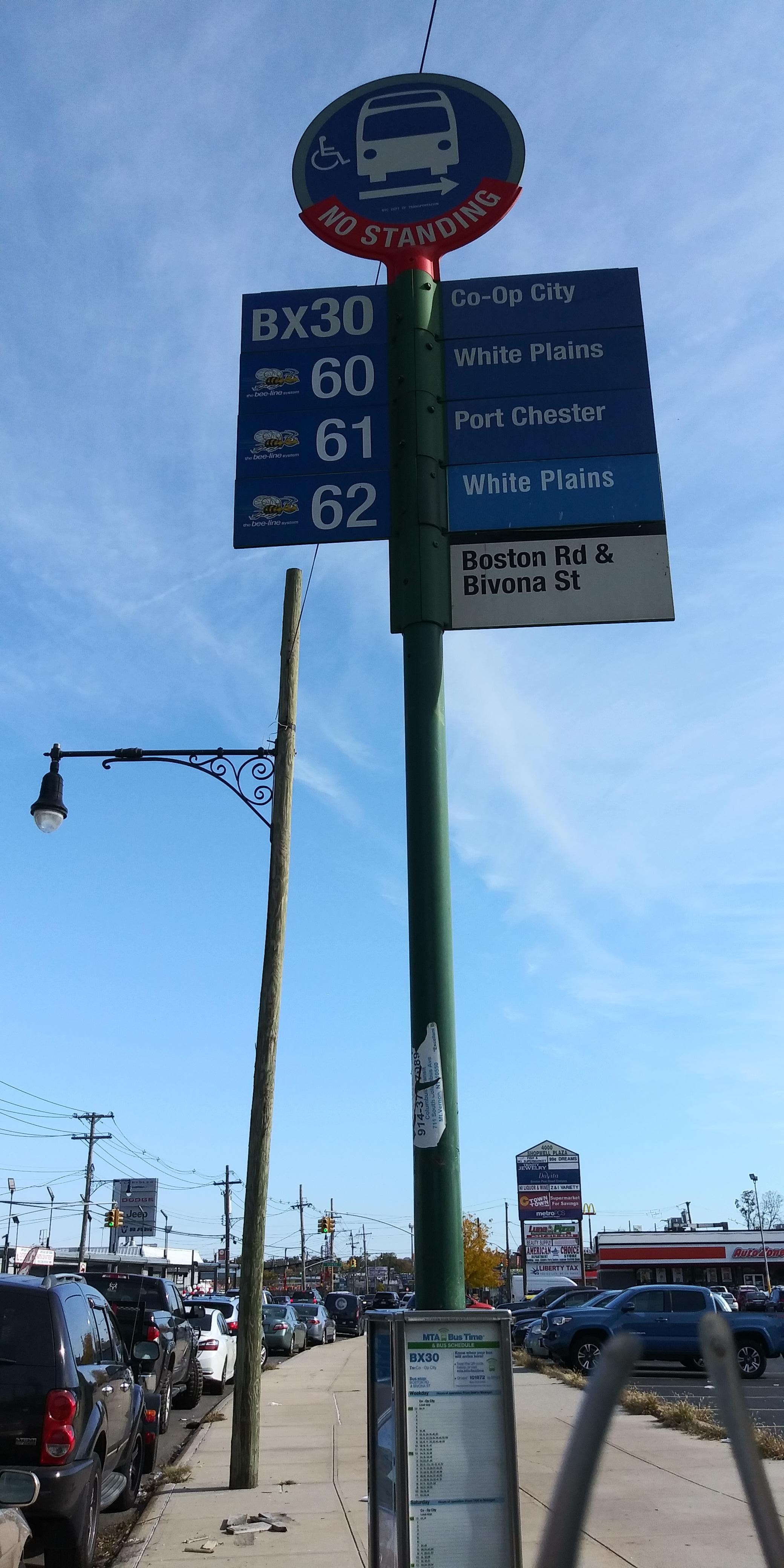
- BX30, Co-Op City Earhart La Via Boston Rd,
- 52, Bivonia St @ Reed Mill Rd,
- 60, White Plains Bus Terminal Lane B,
- 61, Larchmont,
- 62, White Plains Bus Terminal Lane B,
- BX16, Norwood 205 St Sta Via Mundy La,
- 55, Cross County Center @ Macys E Lane,
What are the closest stations to Boston Rd @ Bivona St?
The closest stations to Boston Rd @ Bivona St are:
- Boston Rd @ Bivona St stop is 8 yards away, 1 min walk.
- Dyre Ave @ Boston Rd stop is 240 yards away, 3 min walk.
- Light St @ Dyre Ave stop is 583 yards away, 7 min walk.
- Baychester Av station is 842 yards away, 10 min walk.
Which bus lines stop near Boston Rd @ Bivona St?
These bus lines stop near Boston Rd @ Bivona St: 55, 60, 61.
Which train line stops near Boston Rd @ Bivona St?
2 (To Wassaic)
Which subway line stops near Boston Rd @ Bivona St?
5 (Uptown & The Bronx)
What’s the nearest subway station to Boston Rd @ Bivona St in Bronx?
The nearest subway station to Boston Rd @ Bivona St in Bronx is Baychester Av. It’s a 10 min walk away.
What’s the nearest bus station to Boston Rd @ Bivona St in Bronx?
The nearest bus station to Boston Rd @ Bivona St in Bronx is Boston Rd @ Bivona St. It’s a 1 min walk away.
What time is the first subway to Boston Rd @ Bivona St in Bronx?
The 5 is the first subway that goes to Boston Rd @ Bivona St in Bronx. It stops nearby at 3:02 AM.
What time is the last subway to Boston Rd @ Bivona St in Bronx?
The 5 is the last subway that goes to Boston Rd @ Bivona St in Bronx. It stops nearby at 4:23 AM.
What time is the first bus to Boston Rd @ Bivona St in Bronx?
The BX16 is the first bus that goes to Boston Rd @ Bivona St in Bronx. It stops nearby at 4:22 AM.
What time is the last bus to Boston Rd @ Bivona St in Bronx?
The BX16 is the last bus that goes to Boston Rd @ Bivona St in Bronx. It stops nearby at 1:18 AM.
Boston Rd @ Bivona St station
 Taken by Grisel R.
See Boston Rd @ Bivona St stop, Bronx, on the map
Public transit to Boston Rd @ Bivona St stop (ID: 2226) in Bronx
Looking for directions to Boston Rd @ Bivona St in Bronx, United States?
Download the Moovit App to find the current schedule and step-by-step directions for Bus, Subway or Train routes that pass through Boston Rd @ Bivona St.
Looking for the nearest stops closest to Boston Rd @ Bivona St ? Check out this list of closest stops to your destination: Boston Rd @ Bivona St; Dyre Ave @ Boston Rd; Light St @ Dyre Ave; Baychester Av.
Bus: 55, 60, 61, BX30, 52, 62, BX16.Train: 2.Subway: 5, 2.
We make riding on public transit to Boston Rd @ Bivona St easy, which is why over 1.7 billion users, including users in Bronx trust Moovit as the best app for public transit.
Use the app to navigate to popular places including to the airport, hospital, stadium, grocery store, mall, coffee shop, school, college, and university.
Boston Rd @ Bivona St stop’s code is 2226
The first line to this stop is 61, at 6:10 AM, and the last line is 60 at 5:50 AM.
4006 Boston Road, The Bronx, New York, NY, USA
This stop serves Bee-Line Bus and MTA Bus’s lines
- Boston Rd @ Bivona St,
- Dyre Ave @ Boston Rd,
- Light St @ Dyre Ave
Bus stops near Boston Rd @ Bivona St stop
- Baychester Av
Subway station near Boston Rd @ Bivona St station
- Garwood,
- Bound Brook,
- Polifly Rd at Essex St,
- Flatbush Av-Brooklyn College,
- Short Hills,
- Trenton Transit Center,
- Pawling,
- Van Cortlandt Park-242 St,
- New Hyde Park Rd @Lie S. Service Rd,
- Grand Central,
- Aqueduct-N Conduit Av,
- Lakewood - Us-9 @ E County Line Rd (Northbound),
- Islip,
- Queens Airport Connection Westbound,
- Norwalk Dmv,
- Mahwah,
- Stamford,
- Chambers St/Church St,
- Greenport,
- Classon Av/Fulton St
Popular public transit stations in Bronx
Get around Bronx by public transit!
Traveling around Bronx has never been so easy. See step by step directions as you travel to any attraction, street or major public transit station. View bus and train schedules, arrival times, service alerts and detailed routes on a map, so you know exactly how to get to anywhere in Bronx.
When traveling to any destination around Bronx use Moovit's Live Directions with Get Off Notifications to know exactly where and how far to walk, how long to wait for your line, and how many stops are left. Moovit will alert you when it's time to get off — no need to constantly re-check whether yours is the next stop.
Wondering how to use public transit in Bronx or how to pay for public transit in Bronx? Moovit public transit app can help you navigate your way with public transit easily, and at minimum cost. It includes public transit fees, ticket prices, and costs. Looking for a map of Bronx public transit lines? Moovit public transit app shows all public transit maps in Bronx with all Bus, Train, Subway, Light Rail, Ferry and Cable Car routes and stops on an interactive map.
New York - New Jersey has 6 transit type(s), including: Bus, Train, Subway, Light Rail, Ferry and Cable Car, operated by several transit agencies, including MTA Subway, Metro-North Railroad, LIRR, PATH, MTA New York City Transit - Express routes, MTA Bus, NJ Transit, NYC Ferry, NICE bus, Bee-Line Bus, NJ Transit Rail, Norwalk Transit District, CTTransit - Waterbury-Meriden, Hartford Line and River Valley Transit