Boyer stop - Thursday schedule
| Line | Direction | Time |
|---|---|---|
| 57 | Riquier | 6:04 AM |
| 57 | Riquier | 6:19 AM |
| 33 | Mont Boron | 6:20 AM |
| 15 | Port De Saint-Jean | 6:30 AM |
| 33 | Mont Boron | 6:35 AM |
| 57 | Riquier | 6:35 AM |
| 33 | Mont Boron | 6:46 AM |
| 15 | Port De Saint-Jean | 6:50 AM |
| 57 | Riquier | 6:51 AM |
| 33 | Mont Boron | 7:07 AM |
| 15 | Port De Saint-Jean | 7:10 AM |
| 57 | Riquier | 7:11 AM |
| 57 | Riquier | 7:26 AM |
| 33 | Mont Boron | 7:27 AM |
| 15 | Port De Saint-Jean | 7:30 AM |
| 82 | Vauban | 7:31 AM |
| 57 | Riquier | 7:44 AM |
| 33 | Mont Boron | 7:47 AM |
| 15 | Port De Saint-Jean | 7:50 AM |
| 57 | Riquier | 7:56 AM |
| 33 | Mont Boron | 8:05 AM |
| 15 | Port De Saint-Jean | 8:06 AM |
| 57 | Riquier | 8:07 AM |
| 57 | Riquier | 8:20 AM |
| 15 | Port De Saint-Jean | 8:21 AM |
Directions to Boyer stop (Nice) with public transit
The following transit lines have routes that pass near Boyer
 Bus: 12+, 57, 82, 30, 602.
- Train: C13, C3, P1.
- Light Rail: L1, L3.
How to get to Boyer stop by bus?
Click on the bus route to see step by step directions with maps, line arrival times and updated time schedules.
How to get to Boyer stop by train?
Click on the train route to see step by step directions with maps, line arrival times and updated time schedules.
Bus stops near Boyer stop in Nice
- Place Arson, 4 min walk,
- Bavastro, 5 min walk,
- Garibaldi, 5 min walk,
- Tête Carrée, 5 min walk,
- Risso, 9 min walk,
Train stations near Boyer station in Nice
- Gare De Nice-Riquier, 4 min walk,
Light Rail stations near Boyer station in Nice
- Garibaldi / Le Château, 10 min walk,
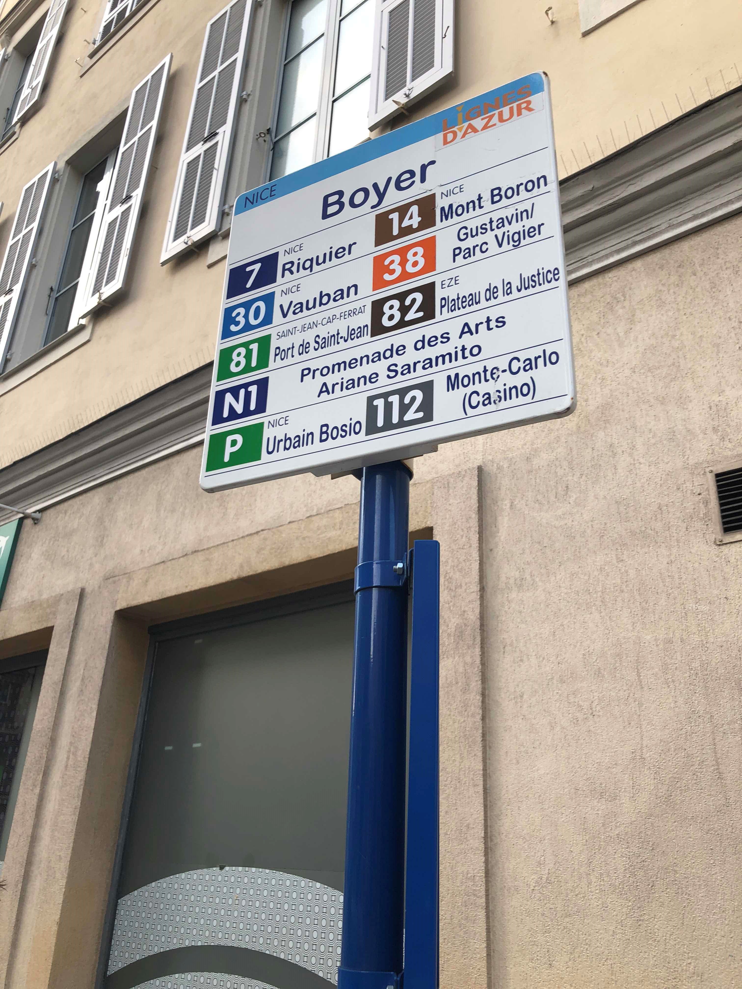
Bus lines to Boyer stop in Nice
- 30, Vauban,
- 602, Office Du Tourisme,
- 15, Port De Saint-Jean,
- 33, Collège Matisse,
- 57, Las Planas / Sappia,
- L1, Henri Sappia,
- 98, Gustavin / Parc Vigier,
- 82, Vauban,
- 19, Levens Village,
- 8+, Saint-Sylvestre,
- 12+, Hôpital Pasteur,
- CE, Les Chênes Verts,
What are the closest stations to Boyer?
The closest stations to Boyer are:
- Place Arson stop is 238 meters away, 4 min walk.
- Gare De Nice-Riquier station is 277 meters away, 4 min walk.
- Bavastro stop is 303 meters away, 5 min walk.
- Garibaldi stop is 306 meters away, 5 min walk.
- Tête Carrée stop is 372 meters away, 5 min walk.
- Risso stop is 674 meters away, 9 min walk.
- Garibaldi / Le Château station is 740 meters away, 10 min walk.
Which bus lines stop near Boyer?
These bus lines stop near Boyer: 12+, 57, 82.
Which train lines stop near Boyer?
These train lines stop near Boyer: C13, C3, P1.
Which light rail lines stop near Boyer?
These light rail lines stop near Boyer: L1, L3.
What’s the nearest light rail station to Boyer in Nice?
The nearest light rail station to Boyer in Nice is Garibaldi / Le Château. It’s a 10 min walk away.
What’s the nearest train station to Boyer in Nice?
The nearest train station to Boyer in Nice is Gare De Nice-Riquier. It’s a 4 min walk away.
What’s the nearest bus station to Boyer in Nice?
The nearest bus station to Boyer in Nice is Place Arson. It’s a 4 min walk away.
What time is the first light rail to Boyer in Nice?
The L3 is the first light rail that goes to Boyer in Nice. It stops nearby at 4:32 AM.
What time is the last light rail to Boyer in Nice?
The L1 is the last light rail that goes to Boyer in Nice. It stops nearby at 1:49 AM.
What time is the first train to Boyer in Nice?
The C3 is the first train that goes to Boyer in Nice. It stops nearby at 5:58 AM.
What time is the last train to Boyer in Nice?
The C13 is the last train that goes to Boyer in Nice. It stops nearby at 10:08 PM.
What time is the first bus to Boyer in Nice?
The 8+ is the first bus that goes to Boyer in Nice. It stops nearby at 6:02 AM.
What time is the last bus to Boyer in Nice?
The 12+ is the last bus that goes to Boyer in Nice. It stops nearby at 1:05 AM.
Boyer station
 Taken by Ranz M.
See Boyer stop, Nice, on the map
Public transit to Boyer stop in Nice
Looking for directions to Boyer in Nice, France?
Download the Moovit App to find the current schedule and step-by-step directions for Bus, Train or Light Rail routes that pass through Boyer.
Looking for the nearest stops closest to Boyer ? Check out this list of closest stops to your destination: Place Arson; Gare De Nice-Riquier; Bavastro; Garibaldi; Tête Carrée; Risso; Garibaldi / Le Château.
Bus: 12+, 57, 82, 30, 602, 15, 33, L1, 98.Train: C13, C3, P1.Light Rail: L1, L3.
We make riding on public transit to Boyer easy, which is why over 1.7 billion users, including users in Nice trust Moovit as the best app for public transit.
Use the app to navigate to popular places including to the airport, hospital, stadium, grocery store, mall, coffee shop, school, college, and university.
The first line to this stop is 57, at 6:04 AM, and the last line is 57 at 12:33 AM.
This stop serves Lignes d'Azur’s lines
Popular routes from Boyer stop, Nice
- Place Arson,
- Bavastro,
- Garibaldi,
- Tête Carrée,
- Risso
Bus stops near Boyer stop
- Gare De Nice-Riquier
Train station near Boyer station
- Garibaldi / Le Château
Light Rail station near Boyer station
- Mont Gros,
- Les 4 Chemins / Saint-Paul-De-Vence,
- La Brigue,
- Pierrefeu,
- Balzac,
- Ruban Bleu,
- Chemin De La Californie,
- Corniche Bellevue,
- Les Clos De Cimiez,
- 11 Novembre,
- Ch. Du Val Bosquet,
- Pepiniere,
- Gare De Carnolès,
- Nécropole,
- Altana,
- Mozart,
- Moyenne Corniche,
- Gamvert,
- Biot 3000,
- Pont De La Roma
Popular public transit stations in Nice
Get around Nice by public transit!
Traveling around Nice has never been so easy. See step by step directions as you travel to any attraction, street or major public transit station. View bus and train schedules, arrival times, service alerts and detailed routes on a map, so you know exactly how to get to anywhere in Nice.
When traveling to any destination around Nice use Moovit's Live Directions with Get Off Notifications to know exactly where and how far to walk, how long to wait for your line, and how many stops are left. Moovit will alert you when it's time to get off — no need to constantly re-check whether yours is the next stop.
Wondering how to use public transit in Nice or how to pay for public transit in Nice? Moovit public transit app can help you navigate your way with public transit easily, and at minimum cost. It includes public transit fees, ticket prices, and costs. Looking for a map of Nice public transit lines? Moovit public transit app shows all public transit maps in Nice with all Bus, Train, Metro, Light Rail, Ferry and Gondola routes and stops on an interactive map.
French riviera - Nice has 6 transit type(s), including: Bus, Train, Metro, Light Rail, Ferry and Gondola, operated by several transit agencies, including Lignes d'Azur, SNCF Voyageurs SA, Aix lebus, ZOU ! Proximité, Marseille, Aix lecar, Métropole lecar, KEOLIS SOPHIA ANTIPOLIS, Palmbus, SNCF VOYAGEURS, Réseau urbain 2023, Est Étang, TransDev RAIL_5241, Réseau Mistral and Salon