Br. Nariño Sur (Ak 10 - Ck 8 Sur) stop - Friday schedule
| Line | Direction | Time |
|---|---|---|
| A702 | El Guavio | 5:01 |
| A618 | Germania | 5:01 |
| A600 | Chapinero [Lunes A Sábado] | 5:02 |
| A725 | Las Nieves | 5:04 |
| A706 | San Diego | 5:04 |
| T13 | Villa Cindy | 5:05 |
| B907 | Terminal Norte | 5:08 |
| A617 | Centro | 5:14 |
| C131 | Bilbao | 5:17 |
| A809 | Marly | 5:18 |
| B919 | Terminal Norte | 5:18 |
| A805 | 7 De Agosto | 5:23 |
| T12 | Calle 100 | 5:29 |
| T25 | Terminal Norte | 5:31 |
| A620 | San Diego | 5:31 |
| A702 | El Guavio | 5:33 |
| A618 | Germania | 5:34 |
| A600 | Chapinero [Lunes A Sábado] | 5:35 |
| T13 | Villa Cindy | 5:35 |
| A725 | Las Nieves | 5:36 |
| A706 | San Diego | 5:36 |
| B907 | Terminal Norte | 5:41 |
| A617 | Centro | 5:45 |
| C131 | Bilbao | 5:47 |
| A809 | Marly | 5:48 |
Directions to Br. Nariño Sur (Ak 10 - Ck 8 Sur) stop (San Cristóbal) with public transit
The following transit lines have routes that pass near Br. Nariño Sur (Ak 10 - Ck 8 Sur)
 Bus: A617, A618, C131, L919, T12.
- Cable Car: 2, H13, H83, L10, M83.
How to get to Br. Nariño Sur (Ak 10 - Ck 8 Sur) stop by bus?
Click on the bus route to see step by step directions with maps, line arrival times and updated time schedules.
How to get to Br. Nariño Sur (Ak 10 - Ck 8 Sur) stop by cable car?
Click on the cable car route to see step by step directions with maps, line arrival times and updated time schedules.
Cable Car stations near Br. Nariño Sur (Ak 10 - Ck 8 Sur) station in San Cristóbal
- Policarpa, 3 min walk,
- Ciudad Jardín - Uan, 4 min walk,
- San Bernardo, 10 min walk,
- Nariño, 12 min walk,
- Hortua, 14 min walk,
Bus stops near Br. Nariño Sur (Ak 10 - Ck 8 Sur) stop in San Cristóbal
- Estación Policarpa (Ak 10 - Cl 2 Sur), 4 min walk,
- Estación Policarpa (Ak 10 - Cl 4 Sur), 4 min walk,
- Br. Nariño Sur (Kr 8 - Cl 7 Sur), 5 min walk,
- Colegio Nuestra Señora Del Pilar (Ac 11 Sur - Kr 8), 5 min walk,
- Cai Ciudad Berna (Ac 11 Sur - Ak 10), 6 min walk,
- Br. San Javier (Ak 7 - Cl 8 Sur), 7 min walk,
Bus lines to Br. Nariño Sur (Ak 10 - Ck 8 Sur) stop in San Cristóbal
- T12, Calle 100,
- T13, Villa Cindy,
- T25, Terminal Norte,
- C131, Bilbao,
- A600, Chapinero [Lunes A Sábado],
- A617, Centro,
- A618, Germania,
- A620, San Diego,
- A702, El Guavio,
- A706, San Diego,
- A725, Las Nieves,
- A805, 7 De Agosto,
- A809, Marly,
- B907, Terminal Norte,
- B919, Terminal Norte,
- T12, San Joaquín,
- T13, Hospital San Blas,
- T25, Potosí,
- H131, Diana Turbay,
- H600, Jerusalén [Lunes A Sábado],
What are the closest stations to Br. Nariño Sur (Ak 10 - Ck 8 Sur)?
The closest stations to Br. Nariño Sur (Ak 10 - Ck 8 Sur) are:
- Policarpa is 209 meters away, 3 min walk.
- Estación Policarpa (Ak 10 - Cl 2 Sur) is 264 meters away, 4 min walk.
- Estación Policarpa (Ak 10 - Cl 4 Sur) is 273 meters away, 4 min walk.
- Ciudad Jardín - Uan is 295 meters away, 4 min walk.
- Br. Nariño Sur (Kr 8 - Cl 7 Sur) is 315 meters away, 5 min walk.
- Colegio Nuestra Señora Del Pilar (Ac 11 Sur - Kr 8) is 377 meters away, 5 min walk.
- Cai Ciudad Berna (Ac 11 Sur - Ak 10) is 391 meters away, 6 min walk.
- Br. San Javier (Ak 7 - Cl 8 Sur) is 524 meters away, 7 min walk.
- San Bernardo is 742 meters away, 10 min walk.
- Nariño is 932 meters away, 12 min walk.
- Hortua is 1021 meters away, 14 min walk.
Which bus lines stop near Br. Nariño Sur (Ak 10 - Ck 8 Sur)?
These bus lines stop near Br. Nariño Sur (Ak 10 - Ck 8 Sur): A617, A618, C131, L919, T12.
Which cable car lines stop near Br. Nariño Sur (Ak 10 - Ck 8 Sur)?
These cable car lines stop near Br. Nariño Sur (Ak 10 - Ck 8 Sur): 2, H13, H83, L10.
What’s the nearest bus station to Br. Nariño Sur (Ak 10 - Ck 8 Sur) in San Cristóbal?
The nearest bus stations to Br. Nariño Sur (Ak 10 - Ck 8 Sur) in San Cristóbal are Estación Policarpa (Ak 10 - Cl 2 Sur) and Estación Policarpa (Ak 10 - Cl 4 Sur). The closest one is a 4 min walk away.
What’s the nearest cable car station to Br. Nariño Sur (Ak 10 - Ck 8 Sur) in San Cristóbal?
The nearest cable car station to Br. Nariño Sur (Ak 10 - Ck 8 Sur) in San Cristóbal is Policarpa. It’s a 3 min walk away.
What time is the first bus to Br. Nariño Sur (Ak 10 - Ck 8 Sur) in San Cristóbal?
The K304 is the first bus that goes to Br. Nariño Sur (Ak 10 - Ck 8 Sur) in San Cristóbal. It stops nearby at 3:02 AM.
What time is the last bus to Br. Nariño Sur (Ak 10 - Ck 8 Sur) in San Cristóbal?
The L919 is the last bus that goes to Br. Nariño Sur (Ak 10 - Ck 8 Sur) in San Cristóbal. It stops nearby at 12:03 AM.
What time is the first cable car to Br. Nariño Sur (Ak 10 - Ck 8 Sur) in San Cristóbal?
The K10 is the first cable car that goes to Br. Nariño Sur (Ak 10 - Ck 8 Sur) in San Cristóbal. It stops nearby at 4:04 AM.
What time is the last cable car to Br. Nariño Sur (Ak 10 - Ck 8 Sur) in San Cristóbal?
The H15 is the last cable car that goes to Br. Nariño Sur (Ak 10 - Ck 8 Sur) in San Cristóbal. It stops nearby at 11:36 PM.
Br. Nariño Sur (Ak 10 - Ck 8 Sur) station
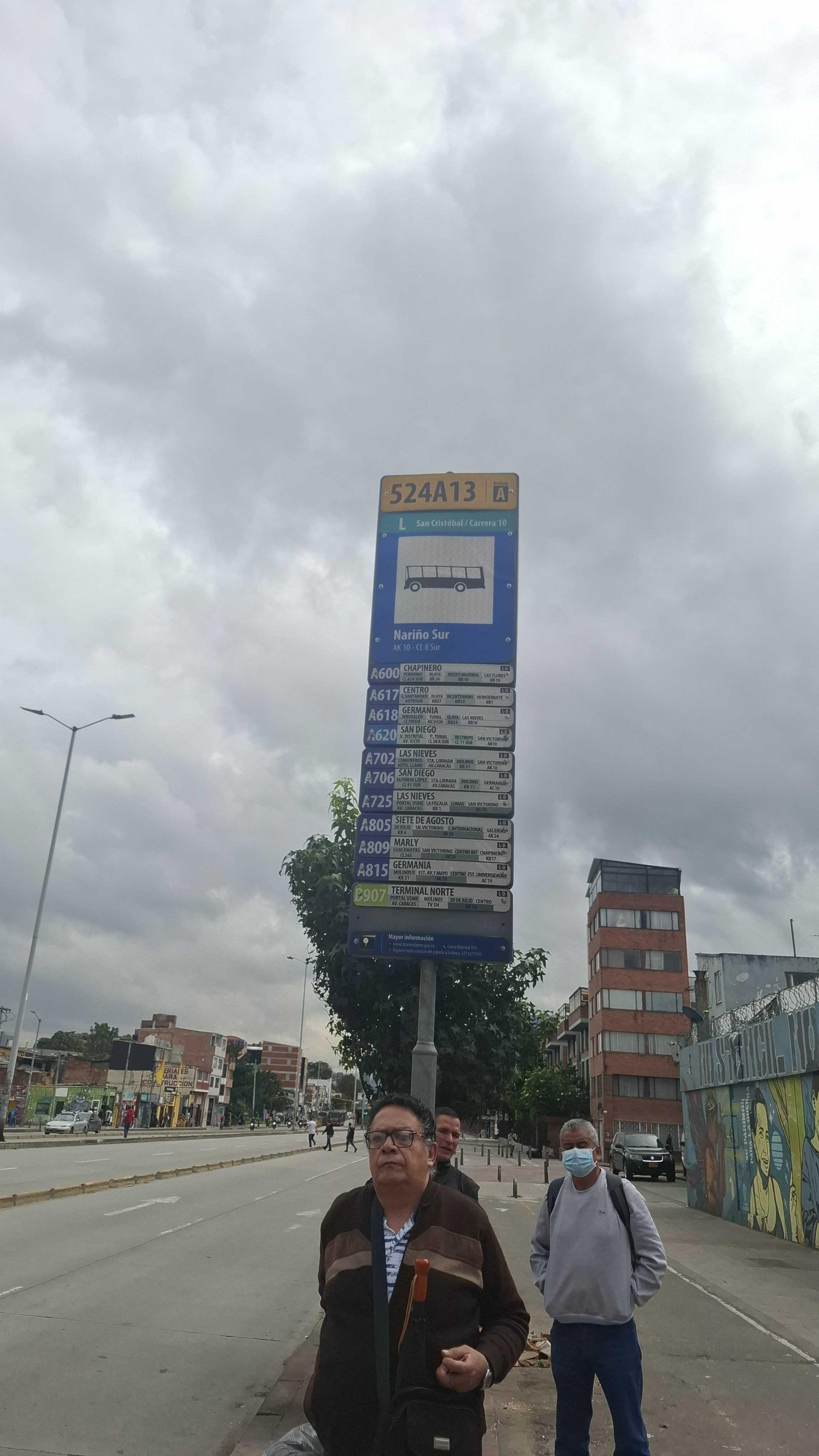 Taken by Anonymous
See Br. Nariño Sur (Ak 10 - Ck 8 Sur) stop, San Cristóbal, on the map
Public transit to Br. Nariño Sur (Ak 10 - Ck 8 Sur) stop (ID: 524A13) in San Cristóbal
Looking for directions to Br. Nariño Sur (Ak 10 - Ck 8 Sur) in San Cristóbal, Colombia?
Download the Moovit App to find the current schedule and step-by-step directions for Bus or Cable Car routes that pass through Br. Nariño Sur (Ak 10 - Ck 8 Sur).
Looking for the nearest stops closest to Br. Nariño Sur (Ak 10 - Ck 8 Sur) ? Check out this list of closest stops to your destination: Policarpa; Estación Policarpa (Ak 10 - Cl 2 Sur); Estación Policarpa (Ak 10 - Cl 4 Sur); Ciudad Jardín - Uan; Br. Nariño Sur (Kr 8 - Cl 7 Sur); Colegio Nuestra Señora Del Pilar (Ac 11 Sur - Kr 8); Cai Ciudad Berna (Ac 11 Sur - Ak 10); Br. San Javier (Ak 7 - Cl 8 Sur); San Bernardo; Nariño; Hortua.
Bus: A617, A618, C131, L919, T12, T13, T25, A600, T13, T25, H131, H600, 15-5, L304, L814, H817, A818, L817, L818.Cable Car: 2, H13, H83, L10, M83.
We make riding on public transit to Br. Nariño Sur (Ak 10 - Ck 8 Sur) easy, which is why over 1.5 million users, including users in San Cristóbal trust Moovit as the best app for public transit.
Use the app to navigate to popular places including to the airport, hospital, stadium, grocery store, mall, coffee shop, school, college, and university.
Br. Nariño Sur (Ak 10 - Ck 8 Sur) stop’s code is 524A13
The first line to this stop is A702, at 5:01, and the last line is T12 at 4:59.
This stop serves TransMiZonal’s lines
- Policarpa,
- Ciudad Jardín - Uan,
- San Bernardo,
- Nariño,
- Hortua
Cable Car stations near Br. Nariño Sur (Ak 10 - Ck 8 Sur) station
- Estación Policarpa (Ak 10 - Cl 2 Sur),
- Estación Policarpa (Ak 10 - Cl 4 Sur),
- Br. Nariño Sur (Kr 8 - Cl 7 Sur),
- Colegio Nuestra Señora Del Pilar (Ac 11 Sur - Kr 8),
- Cai Ciudad Berna (Ac 11 Sur - Ak 10),
- Br. San Javier (Ak 7 - Cl 8 Sur)
Bus stops near Br. Nariño Sur (Ak 10 - Ck 8 Sur) stop
- Castillo Marroquín (Chía: Vía La Caro),
- Centro Comercial Mi Placita (Ac 68 - Kr 65) (A),
- Estación Prado (Auto Norte - Cl 128a),
- Universidad Javeriana (Ak 7 - Cl 40),
- Cai Paraíso (Dg 72a Sur - Kr 72n),
- Br. Tibabuyes (Ac 132 - Kr 123),
- La Campiña,
- Coliseo El Salitre (Ak 68 - Ac 63) (A),
- Salón Comunal Arabia (Cl 23g - Kr 98),
- Br. Interindustrial (Av. Centenario - Kr 78g),
- Br. Prados De Castilla (Cl 6a - Kr 90c),
- Paloquemao,
- Estación Gobernación (Ac 26 - Kr 54),
- Condominios San Sebastián (Kr 3 - Cl 1c),
- Calle 85,
- Estación Santa Lucía (Cl 46 Sur - Kr 19a),
- Estación Concejo De Bogotá (Ac 26 - Av. Nqs),
- Inem Kennedy (Cl 38c Sur - Kr 79g),
- Br. Alcázares Norte (Ak 24 - Ac 72),
- Clínica Méderi (Av. NQS - Cl 24)
Popular public transit stations in San Cristóbal
Get around San Cristóbal by public transit!
Traveling around San Cristóbal has never been so easy. See step by step directions as you travel to any attraction, street or major public transit station. View bus and train schedules, arrival times, service alerts and detailed routes on a map, so you know exactly how to get to anywhere in San Cristóbal.
When traveling to any destination around San Cristóbal use Moovit's Live Directions with Get Off Notifications to know exactly where and how far to walk, how long to wait for your line, and how many stops are left. Moovit will alert you when it's time to get off — no need to constantly re-check whether yours is the next stop.
Wondering how to use public transit in San Cristóbal or how to pay for public transit in San Cristóbal? Moovit public transit app can help you navigate your way with public transit easily, and at minimum cost. It includes public transit fees, ticket prices, and costs. Looking for a map of San Cristóbal public transit lines? Moovit public transit app shows all public transit maps in San Cristóbal with all Bus, Cable Car and Funicular routes and stops on an interactive map.
Bogota has 3 transit type(s), including: Bus, Cable Car and Funicular, operated by several transit agencies, including TransMiZonal, Buses Troncales, TransMiCable, Cerro de Monserrate, Aeropuerto El Dorado, Cootranscajicá Ltda., Flota Chia Ltda. and Auto Servicio Chía Ltda.