How to get to CDU Oftersheim by bus?
Click on the bus route to see step by step directions with maps, line arrival times and updated time schedules.
How to get to CDU Oftersheim by train?
Click on the train route to see step by step directions with maps, line arrival times and updated time schedules.
Bus stops near CDU Oftersheim
Train station near CDU Oftersheim
- Schwetzingen, Bahnhof, 19 min walk,VIEW
Bus lines to CDU Oftersheim
- 712, Oftersheim, am Alten Schießst.,VIEW
- 717, Speyer, Hbf/Zob,VIEW
- 728, Schwetzingen, Grenzhöfer Str.,VIEW
- 750, Wiesloch-Walldorf, Bf,VIEW
- RB67, Frankfurt (Main) Hauptbahnhof,VIEW
- RE 9, Mannheim, Hauptbahnhof,VIEW
- S7, Hockenheim, Bahnhof,VIEW
- S9, Ludwigshafen, Hauptbahnhof,VIEW
- 715, Schwetzingen, Bahnhof,VIEW
- 716, Schwetzingen, Bahnhof,VIEW
What are the closest stations to CDU Oftersheim?
The closest stations to CDU Oftersheim are:
- Oftersheim, Rathaus is 69 meters away, 2 min walk.
- Oftersheim, Bahnhof is 629 meters away, 9 min walk.
- Schwetzingen, Südtangente is 1196 meters away, 16 min walk.
- Schwetzingen, Bahnhof is 1441 meters away, 19 min walk.
Which train lines stop near CDU Oftersheim?
These train lines stop near CDU Oftersheim: S6, S9.
Which light rail line stops near CDU Oftersheim?
S9 (Karlsruhe Hauptbahnhof)
Which bus lines stop near CDU Oftersheim?
These bus lines stop near CDU Oftersheim: 710, 717, 750.
What’s the nearest train station to CDU Oftersheim?
The nearest train station to CDU Oftersheim is Schwetzingen, Bahnhof. It’s a 19 min walk away.
What’s the nearest bus station to CDU Oftersheim?
The nearest bus station to CDU Oftersheim is Oftersheim, Rathaus. It’s a 2 min walk away.
What time is the first light rail to CDU Oftersheim?
The S9 is the first light rail that goes to CDU Oftersheim. It stops nearby at 4:07 AM.
What time is the last light rail to CDU Oftersheim?
The S9 is the last light rail that goes to CDU Oftersheim. It stops nearby at 1:35 AM.
What time is the first train to CDU Oftersheim?
The S6 is the first train that goes to CDU Oftersheim. It stops nearby at 4:02 AM.
What time is the last train to CDU Oftersheim?
The S9 is the last train that goes to CDU Oftersheim. It stops nearby at 1:10 AM.
What time is the first bus to CDU Oftersheim?
The 717 is the first bus that goes to CDU Oftersheim. It stops nearby at 5:12 AM.
What time is the last bus to CDU Oftersheim?
The 717 is the last bus that goes to CDU Oftersheim. It stops nearby at 12:25 AM.
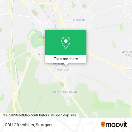
See CDU Oftersheim on the map
Public Transportation to CDU Oftersheim
Wondering how to get to CDU Oftersheim? Moovit helps you find the best way to get to CDU Oftersheim with step-by-step directions from the nearest public transit station.
Moovit provides free maps and live directions to help you navigate through your city. View schedules, routes, timetables, and find out how long does it take to get to CDU Oftersheim in real time.
Looking for the nearest stop or station to CDU Oftersheim? Check out this list of stops closest to your destination: Oftersheim, Rathaus; Oftersheim, Bahnhof; Schwetzingen; Schwetzingen.
Train: S6, S9, RE9, S12, RE60.Light Rail: S9.Bus: 710, 717, 750, 712, 728, RB67, RE 9, S7, S9, 715, 716.
Want to see if there’s another route that gets you there at an earlier time? Moovit helps you find alternative routes or times. Get directions from and directions to CDU Oftersheim easily from the Moovit App or Website.
We make riding to CDU Oftersheim easy, which is why over 1.5 million users, including users in Oftersheim, trust Moovit as the best app for public transit. You don’t need to download an individual bus app or train app, Moovit is your all-in-one transit app that helps you find the best bus time or train time available.
For information on prices of bus, train and light rail, costs and ride fares to CDU Oftersheim, please check the Moovit app.
Use the app to navigate to popular places including to the airport, hospital, stadium, grocery store, mall, coffee shop, school, college, and university.
CDU Oftersheim Address: Franz-Schubert-Straße 1 68723 Oftersheim street in Oftersheim
- St. Kilian Kindergarten,
- Spielplatz - Moltkestraße 2,
- Hintergrundbewegung,
- Hgb! Medien & Entertainment Steve Kraft,
- Optic Hartmann,
- Vereinigte Lohnsteuerhilfe E.V.,
- Kleine Bühne Oftersheim - Produktion 2013,
- St. Kilian,
- Columbus Consulting - Inh. Dr. Markus Lauff,
- Josefshaus,
- Büro Für Gestaltung_Raum + Möbel,
- Friseursalon Thorsten Treiber,
- Trödelladen,
- Bistro Metropol,
- Wunderkiste - Alles Rund Ums Kind,
- Theraplay Institut,
- Dienstleistungen Koffeman,
- Naturheilpraxis Dagmar Moles,
- Dpd-Partner,
- Nkd
Places Near CDU Oftersheim
- Porsche Museum, Zuffenhausen,
- Klinikum Stuttgart - Katharinenhospital, Stuttgart-Mitte,
- Im Wizemann (Halle), Bad Cannstatt,
- Porsche-Arena, Bad Cannstatt,
- Hanns-Martin-Schleyer-Halle, Bad Cannstatt,
- Mercedes-Benz Museum (Mercedes Museum Stuttgart), Bad Cannstatt,
- Mettingen Eros-Center Puff Laufhaus, Esslingen Am Neckar,
- Waldfriedhof, Degerloch,
- Gasometer Pforzheim, Pforzheim,
- Pariser Platz Stuttgart, Stuttgart-Mitte,
- SI-Centrum, Möhringen,
- Hanns-Martin-Schleyer-Halle (Stuttgart Hans-Martin-Schleyerhalle), Bad Cannstatt,
- Marmorsaal Im Weissenburgpark, Stuttgart-Süd,
- Mercedes-Benz Museum, Bad Cannstatt,
- Gleis 101/102 (tief), Stuttgart-Mitte,
- Geilhaus Haus 33a, Reutlingen-Betzingen,
- FlixBus Haltestelle, Stuttgart,
- Hauptbahnhof Stuttgart, Stuttgart-Mitte,
- Schleyerhalle, Bad Cannstatt,
- Wilhelma (U-Bahn Wilhelma), Bad Cannstatt
How to get to popular places in Stuttgart with public transit
Get around Oftersheim by public transit!
Traveling around Oftersheim has never been so easy. See step by step directions as you travel to any attraction, street or major public transit station. View bus and train schedules, arrival times, service alerts and detailed routes on a map, so you know exactly how to get to anywhere in Oftersheim.
When traveling to any destination around Oftersheim use Moovit's Live Directions with Get Off Notifications to know exactly where and how far to walk, how long to wait for your line, and how many stops are left. Moovit will alert you when it's time to get off — no need to constantly re-check whether yours is the next stop.
Wondering how to use public transit in Oftersheim or how to pay for public transit in Oftersheim? Moovit public transit app can help you navigate your way with public transit easily, and at minimum cost. It includes public transit fees, ticket prices, and costs. Looking for a map of Oftersheim public transit lines? Moovit public transit app shows all public transit maps in Oftersheim with all Bus, Train, Subway, Light Rail, Ferry, S-Bahn and Funicular routes and stops on an interactive map.
Stuttgart has 7 transit type(s), including: Bus, Train, Subway, Light Rail, Ferry, S-Bahn and Funicular, operated by several transit agencies, including SSB - Stadtbahn, SSB, SSB - Seilbahn / Zacke, S-Bahn Stuttgart, Rhein-Neckar-Verkehr GmbH (rnv), Karlsruher Verkehrsverbund, DB AG, DB Regiobus BW, Arverio Baden-Württemberg GmbH, DB RegioNetz Verkehrs GmbH Westfrankenbahn, DB Regio AG Baden-Württemberg, Südwestdeutsche Verkehrs-AG, DB Regio AG Mitte Region Hessen, DB and Bodensee-Oberschwaben-Bahn