Carroll Ave & Chester St stop - Monday schedule
| Line | Direction | Time |
|---|---|---|
| 25 | Takoma | 5:02 AM |
| 17 | Silver Spring | 5:22 AM |
| 25 | Takoma | 5:52 AM |
| 17 | Silver Spring | 5:57 AM |
| 18 | Silver Spring Via Takoma | 6:17 AM |
| 17 | Silver Spring | 6:27 AM |
| 25 | Takoma | 6:42 AM |
| 17 | Silver Spring | 6:57 AM |
| 18 | Silver Spring Via Takoma | 6:57 AM |
| 17 | Silver Spring | 7:27 AM |
| 18 | Silver Spring Via Takoma | 7:32 AM |
| 25 | Takoma | 7:32 AM |
| 17 | Silver Spring | 7:57 AM |
| 18 | Silver Spring Via Takoma | 8:12 AM |
| 17 | Silver Spring | 8:27 AM |
| 25 | Takoma | 8:27 AM |
| 18 | Silver Spring Via Takoma | 8:47 AM |
| 17 | Silver Spring | 8:57 AM |
| 17 | Silver Spring | 9:27 AM |
| 18 | Silver Spring Via Takoma | 9:27 AM |
| 25 | Takoma | 9:32 AM |
| 17 | Silver Spring | 10:02 AM |
| 18 | Silver Spring Via Takoma | 10:12 AM |
| 17 | Silver Spring | 10:37 AM |
| 18 | Silver Spring Via Takoma | 10:57 AM |
Directions to Carroll Ave & Chester St stop (Montgomery County) with public transit
The following transit lines have routes that pass near Carroll Ave & Chester St
 Bus: 17, 18, 25, M12, P43.
- Train: MARC.
- Metro: RED.
How to get to Carroll Ave & Chester St stop by bus?
Click on the bus route to see step by step directions with maps, line arrival times and updated time schedules.
How to get to Carroll Ave & Chester St stop by metro?
Click on the metro route to see step by step directions with maps, line arrival times and updated time schedules.
Bus stops near Carroll Ave & Chester St stop in Montgomery County
- Carroll Ave & Glenside Dr, 3 min walk,
- E University Bv & Merrimac Dr (Terminal), 6 min walk,
- University Bv & Lebanon St, 7 min walk,
- Lebanon St+University Bl, 8 min walk,
- Takoma Langley Crossroads Transit Center + Bus Bay A, 8 min walk,
- Takoma Langley Park Transit Center at Bus Bay B, 9 min walk,
Metro stations near Carroll Ave & Chester St station in Montgomery County
- Takoma, 37 min walk,
Train stations near Carroll Ave & Chester St station in Montgomery County
- Silver Spring Marc Wb, 48 min walk,
Bus lines to Carroll Ave & Chester St stop in Montgomery County
- 17, Silver Spring,
- 18, Silver Spring Via Takoma,
- 25, Takoma Langley,
- 15, Takoma Langley Transit Center,
- M12, East To Hyattsville Xing,
- 16, Silver Spring,
- P31, East To New Carrollton,
- M60, North To Plum Orchard,
- M6X, North To Fda-Hillandale,
- P43, Takoma Langley Transit Center,
What are the closest stations to Carroll Ave & Chester St?
The closest stations to Carroll Ave & Chester St are:
- Carroll Ave & Glenside Dr stop is 227 yards away, 3 min walk.
- E University Bv & Merrimac Dr (Terminal) is 512 yards away, 6 min walk.
- University Bv & Lebanon St stop is 582 yards away, 7 min walk.
- Lebanon St+University Bl stop is 646 yards away, 8 min walk.
- Takoma Langley Crossroads Transit Center + Bus Bay A stop is 663 yards away, 8 min walk.
- Takoma Langley Park Transit Center at Bus Bay B stop is 696 yards away, 9 min walk.
- Takoma station is 3169 yards away, 37 min walk.
- Silver Spring Marc Wb station is 4142 yards away, 48 min walk.
Which bus lines stop near Carroll Ave & Chester St?
These bus lines stop near Carroll Ave & Chester St: 17, 18, 25, M12, P43.
Which metro line stops near Carroll Ave & Chester St?
RED (Glenmont)
What’s the nearest bus station to Carroll Ave & Chester St in Montgomery County?
The nearest bus station to Carroll Ave & Chester St in Montgomery County is Carroll Ave & Glenside Dr. It’s a 3 min walk away.
What time is the first metro to Carroll Ave & Chester St in Montgomery County?
The RED is the first metro that goes to Carroll Ave & Chester St in Montgomery County. It stops nearby at 5:09 AM.
What time is the last metro to Carroll Ave & Chester St in Montgomery County?
The RED is the last metro that goes to Carroll Ave & Chester St in Montgomery County. It stops nearby at 12:30 AM.
What time is the first train to Carroll Ave & Chester St in Montgomery County?
The MARC is the first train that goes to Carroll Ave & Chester St in Montgomery County. It stops nearby at 5:51 AM.
What time is the last train to Carroll Ave & Chester St in Montgomery County?
The MARC is the last train that goes to Carroll Ave & Chester St in Montgomery County. It stops nearby at 7:37 PM.
What time is the first bus to Carroll Ave & Chester St in Montgomery County?
The 15 is the first bus that goes to Carroll Ave & Chester St in Montgomery County. It stops nearby at 4:20 AM.
What time is the last bus to Carroll Ave & Chester St in Montgomery County?
The M12 is the last bus that goes to Carroll Ave & Chester St in Montgomery County. It stops nearby at 2:34 AM.
Carroll Ave & Chester St station
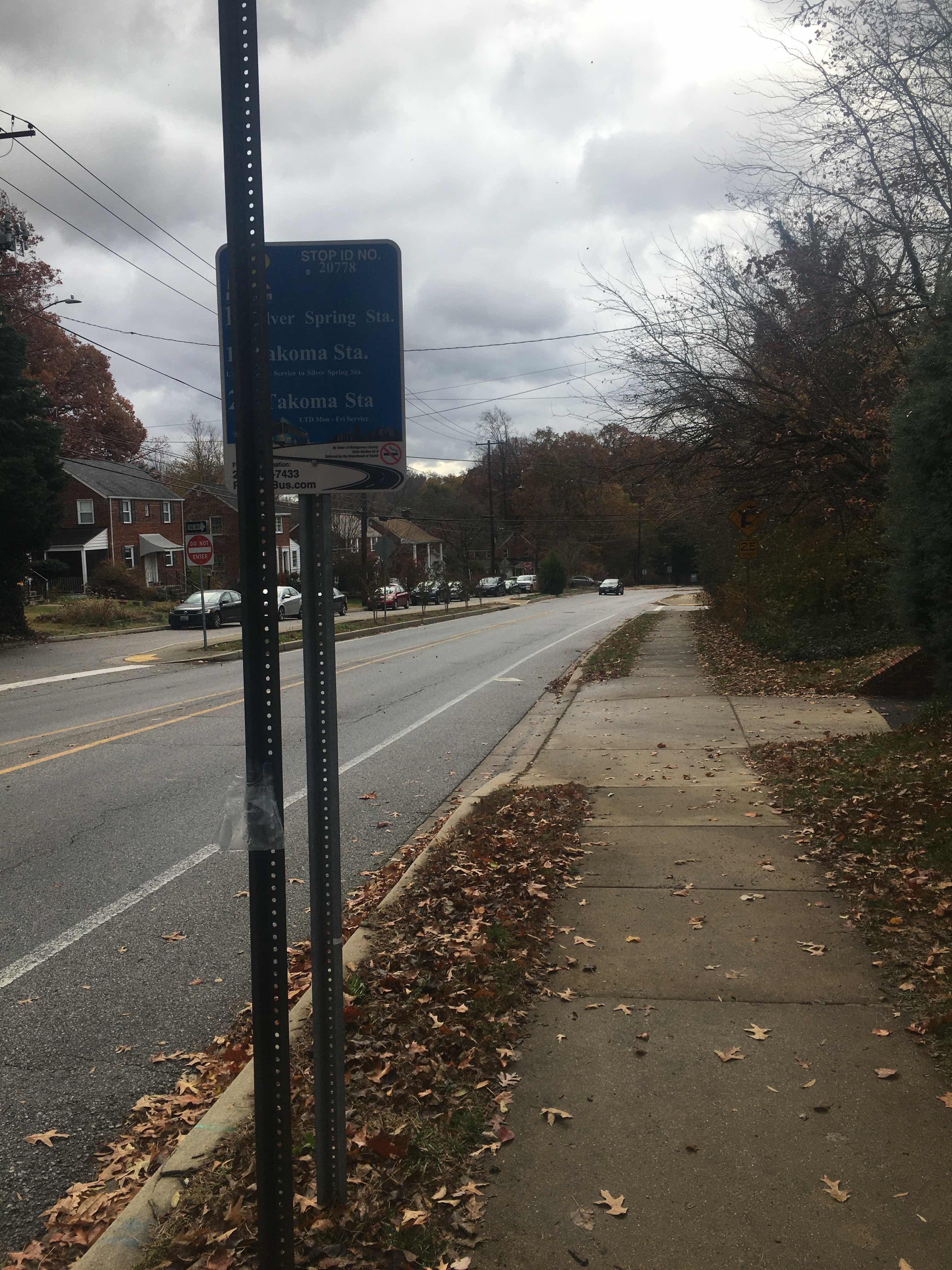 Taken by Anonymous
See Carroll Ave & Chester St stop, Montgomery County, on the map
Public transit to Carroll Ave & Chester St stop (ID: 20778) in Montgomery County
Looking for directions to Carroll Ave & Chester St in Montgomery County, United States?
Download the Moovit App to find the current schedule and step-by-step directions for Bus or Metro routes that pass through Carroll Ave & Chester St.
Looking for the nearest stops closest to Carroll Ave & Chester St ? Check out this list of closest stops to your destination: Carroll Ave & Glenside Dr; E University Bv & Merrimac Dr (Terminal); University Bv & Lebanon St; Lebanon St+University Bl; Takoma Langley Crossroads Transit Center + Bus Bay A; Takoma Langley Park Transit Center at Bus Bay B; Takoma; Silver Spring Marc Wb.
Bus: 17, 18, 25, M12, P43, 15, 16, P31, M60.Train: MARC.Metro: RED.
We make riding on public transit to Carroll Ave & Chester St easy, which is why over 1.7 billion users, including users in Montgomery County trust Moovit as the best app for public transit.
Use the app to navigate to popular places including to the airport, hospital, stadium, grocery store, mall, coffee shop, school, college, and university.
Carroll Ave & Chester St stop’s code is 20778
The first line to this stop is 25, at 5:02 AM, and the last line is 17 at 4:46 AM.
8100 Chester St, Silver Spring, MD, USA
This stop serves Montgomery County Ride On’s lines
- Carroll Ave & Glenside Dr,
- E University Bv & Merrimac Dr (Terminal),
- University Bv & Lebanon St,
- Lebanon St+University Bl,
- Takoma Langley Crossroads Transit Center + Bus Bay A,
- Takoma Langley Park Transit Center at Bus Bay B
Bus stops near Carroll Ave & Chester St stop
- Takoma
Metro station near Carroll Ave & Chester St station
- Silver Spring Marc Wb
Train station near Carroll Ave & Chester St station
- Minnesota Av+Bay G,
- Navy Yard Metro Station,
- Bladensburg Rd Ne+#3174,
- Oregon Av Nw+#7010,
- Greenbelt Rd+Rhode Island Av,
- Omniride Transit Center Departures,
- Georgia Av+Seminary Rd,
- Arlington Bl+Graham Rd,
- Alabama Av Se+Marion Barry Av SE,
- 5380 Holmes Run Pkwy,
- Centreville Park And Ride Bay A,
- Michigan Av Ne+N Capitol St NE,
- Silver Spring Station & Bay 232,
- Riverdale Rd & Carrollton Mall,
- Pennsylvania Av Se+L'Enfant Sq SE,
- Culpeper Amtrak,
- Washington St @ Broad St,
- Knoll Dr / Columbia Medical Plan,
- 9 St Ne+T St NE,
- Layhill Rd & Bel Pre Rd
Popular public transit stations in Montgomery County
Get around Montgomery County by public transit!
Traveling around Montgomery County has never been so easy. See step by step directions as you travel to any attraction, street or major public transit station. View bus and train schedules, arrival times, service alerts and detailed routes on a map, so you know exactly how to get to anywhere in Montgomery County.
When traveling to any destination around Montgomery County use Moovit's Live Directions with Get Off Notifications to know exactly where and how far to walk, how long to wait for your line, and how many stops are left. Moovit will alert you when it's time to get off — no need to constantly re-check whether yours is the next stop.
Wondering how to use public transit in Montgomery County or how to pay for public transit in Montgomery County? Moovit public transit app can help you navigate your way with public transit easily, and at minimum cost. It includes public transit fees, ticket prices, and costs. Looking for a map of Montgomery County public transit lines? Moovit public transit app shows all public transit maps in Montgomery County with all Bus, Train, Metro, Light Rail and Ferry routes and stops on an interactive map.
Washington, D.C. - Baltimore, MD has 5 transit type(s), including: Bus, Train, Metro, Light Rail and Ferry, operated by several transit agencies, including WMATA, Montgomery County Ride On, Fairfax Connector, Prince Georges County's TheBus, PRTC, DASH - Alexandria, Arlington Transit (ART), RTA of Central Maryland, MDOT MTA, MDOT MTA Light RailLink, MDOT MTA Commuter Bus, MDOT MTA Local Bus, FXBGO!, Virginia Railway Express (VRE) and MARC