Carson St + Maple Av stop - Saturday schedule
| Line | Direction | Time |
|---|---|---|
| 3 | Downtown Long Beach Station | 5:50 AM |
| 3 | Downtown Long Beach Station | 6:26 AM |
| 3 | Downtown Long Beach Station | 7:01 AM |
| 3 | Downtown Long Beach Station | 7:25 AM |
| 3 | Downtown Long Beach Station | 7:45 AM |
| 3 | Downtown Long Beach Station | 8:05 AM |
| 3 | Downtown Long Beach Station | 8:40 AM |
| 3 | Downtown Long Beach Station | 9:00 AM |
| 3 | Downtown Long Beach Station | 9:21 AM |
| 3 | Downtown Long Beach Station | 9:44 AM |
| 3 | Downtown Long Beach Station | 10:07 AM |
| 3 | Downtown Long Beach Station | 10:35 AM |
| 3 | Downtown Long Beach Station | 11:10 AM |
| 3 | Downtown Long Beach Station | 11:36 AM |
| 3 | Downtown Long Beach Station | 12:09 PM |
| 3 | Downtown Long Beach Station | 12:40 PM |
| 3 | Downtown Long Beach Station | 1:02 PM |
| 3 | Downtown Long Beach Station | 1:32 PM |
| 3 | Downtown Long Beach Station | 2:00 PM |
| 3 | Downtown Long Beach Station | 2:18 PM |
| 3 | Downtown Long Beach Station | 2:40 PM |
| 3 | Downtown Long Beach Station | 3:10 PM |
| 3 | Downtown Long Beach Station | 3:41 PM |
| 3 | Downtown Long Beach Station | 3:56 PM |
| 3 | Downtown Long Beach Station | 4:17 PM |
Directions to Carson St + Maple Av stop (Torrance) with public transit
The following transit lines have routes that pass near Carson St + Maple Av
 Bus: 3, 7, 9, 2, 6.
How to get to Carson St + Maple Av stop by bus?
Click on the bus route to see step by step directions with maps, line arrival times and updated time schedules.
Bus stops near Carson St + Maple Av stop in Torrance
- Carson St + Madrona Av, 6 min walk,
- Madrona Av at Carson St, 7 min walk,
- Torrance Bl at Maple Av, 8 min walk,
Bus lines to Carson St + Maple Av stop in Torrance
- 3, Downtown Long Beach Station,
- 2, El Camino College,
- 6, Artesia Station,
- 7, Sepulveda Blvd to Avalon Blvd,
- 9, Del Amo Mall,
- 1, Harbor Freeway Station,
- 4X, Torrance,
What are the closest stations to Carson St + Maple Av?
The closest stations to Carson St + Maple Av are:
- Carson St + Madrona Av stop is 488 yards away, 6 min walk.
- Madrona Av at Carson St stop is 585 yards away, 7 min walk.
- Torrance Bl at Maple Av stop is 633 yards away, 8 min walk.
Which bus line stops near Carson St + Maple Av?
3 (Redondo Beach Pier)
What’s the nearest bus station to Carson St + Maple Av in Torrance?
The nearest bus station to Carson St + Maple Av in Torrance is Carson St + Madrona Av. It’s a 6 min walk away.
What time is the first bus to Carson St + Maple Av in Torrance?
The 3 is the first bus that goes to Carson St + Maple Av in Torrance. It stops nearby at 5:24 AM.
What time is the last bus to Carson St + Maple Av in Torrance?
The 7 is the last bus that goes to Carson St + Maple Av in Torrance. It stops nearby at 10:27 PM.
Carson St + Maple Av station
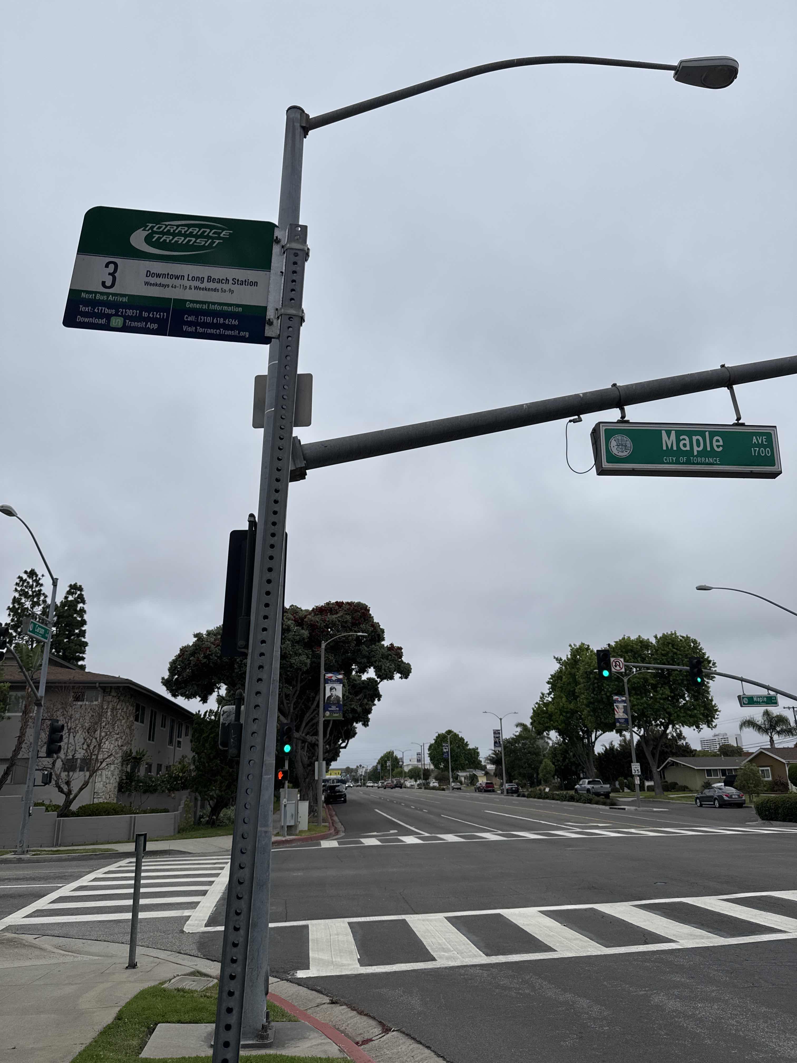 Taken by Anonymous
See Carson St + Maple Av stop, Torrance, on the map
Public transit to Carson St + Maple Av stop (ID: 213031) in Torrance
Looking for directions to Carson St + Maple Av in Torrance, United States?
Download the Moovit App to find the current schedule and step-by-step directions for Bus routes that pass through Carson St + Maple Av.
Looking for the nearest stops closest to Carson St + Maple Av ? Check out this list of closest stops to your destination: Carson St + Madrona Av; Madrona Av at Carson St; Torrance Bl at Maple Av.
Bus: 3, 7, 9, 2, 6, 1, 4X.
We make riding on public transit to Carson St + Maple Av easy, which is why over 1.7 billion users, including users in Torrance trust Moovit as the best app for public transit.
Use the app to navigate to popular places including to the airport, hospital, stadium, grocery store, mall, coffee shop, school, college, and university.
Carson St + Maple Av stop’s code is 213031
The first line to this stop is 3, at 5:50 AM, and the last line is 3 at 9:40 PM.
2940 Carson St, Torrance, CA, USA
This stop serves Torrance Transit System’s lines
- Carson St + Madrona Av,
- Madrona Av at Carson St,
- Torrance Bl at Maple Av
Bus stops near Carson St + Maple Av stop
- Crenshaw Bl at El Camino College,
- Imperial / Yukon,
- Carson St + Figueroa St,
- Plummer & Tampa,
- Willow & Long Beach Blvd SE,
- Mcbean Pkwy & Valencia Blvd,
- Olive View Medical Center,
- Expo / Crenshaw - E Line,
- San Fernando / California,
- Vineland / Magnolia,
- Crenshaw & 39th St,
- Wilshire / Normandie Station,
- Cal State University / Eastern,
- Olive / San Fernando,
- Olympic / Doheny,
- 55th & Compton Ave. (CW),
- Vanowen / Sepulveda,
- Pico WB & LA Brea Ns,
- Figueroa St & Adams Blvd,
- Magnolia / Whitsett
Popular public transit stations in Torrance
Get around Torrance by public transit!
Traveling around Torrance has never been so easy. See step by step directions as you travel to any attraction, street or major public transit station. View bus and train schedules, arrival times, service alerts and detailed routes on a map, so you know exactly how to get to anywhere in Torrance.
When traveling to any destination around Torrance use Moovit's Live Directions with Get Off Notifications to know exactly where and how far to walk, how long to wait for your line, and how many stops are left. Moovit will alert you when it's time to get off — no need to constantly re-check whether yours is the next stop.
Wondering how to use public transit in Torrance or how to pay for public transit in Torrance? Moovit public transit app can help you navigate your way with public transit easily, and at minimum cost. It includes public transit fees, ticket prices, and costs. Looking for a map of Torrance public transit lines? Moovit public transit app shows all public transit maps in Torrance with all Bus, Train, Subway, Ferry and Funicular routes and stops on an interactive map.
Los Angeles has 5 transit type(s), including: Bus, Train, Subway, Ferry and Funicular, operated by several transit agencies, including Metro, Metro Event Service, Alhambra Community Transit (ACT), Arcadia Transit, Artesia Transit, AVTA, Baldwin Park Transit, Beach Cities Transit, Beaumont Transit, Bell Gardens Town Trolley, Bellflower Bus, Big Blue Bus, Burbank Bus, Calabasas Trolley and Camarillo Area Transit